
The Blue Mountains are a mountainous region and a mountain range located in New South Wales, Australia. The region is considered to be part of the western outskirts of the Greater Sydney area. The region borders on Sydney's main metropolitan area, its foothills starting about 50 kilometres (31 mi) west of centre of the state capital, close to Penrith. The public's understanding of the extent of the Blue Mountains is varied, as it forms only part of an extensive mountainous area associated with the Great Dividing Range. As defined in 1970, the Blue Mountains region is bounded by the Nepean and Hawkesbury rivers in the east, the Coxs River and Lake Burragorang to the west and south, and the Wolgan and Colo rivers to the north. Geologically, it is situated in the central parts of the Sydney Basin.

Gregory Blaxland was an English pioneer farmer and explorer in Australia, noted especially for initiating and co-leading the first successful crossing of the Blue Mountains by European settlers.

The Jamison Valley forms part of the Coxs River canyon system in the Blue Mountains of New South Wales, Australia. It is situated approximately 100 kilometres west of Sydney, capital of New South Wales, and a few kilometres south of Katoomba, the main town in the Blue Mountains.

Warrimoo is a medium-sized village in the lower Blue Mountains of New South Wales, Australia, 273 metres above sea level. The state government's electorate is Blue Mountains and the state member is Labor's Trisha Lee Doyle.

Lawson is a town in the Blue Mountains area of New South Wales, Australia. It is located on the Great Western Highway between Hazelbrook in the east and Bullaburra in the west. Lawson has a station on the Main Western line. The town is also served by a public swimming pool and over the years has developed into the commercial hub of the mid-mountains area, which spans from Linden to Bullaburra, boasting a significant industrialized area as well as a shopping centre located on the south-eastern side of the highway.

Blaxland is a town in the Blue Mountains of New South Wales, Australia. Blaxland is located 65 kilometres west of Sydney in the local government area of the City of Blue Mountains. It is at an altitude of 234 metres and borders the townships of Glenbrook, Mount Riverview and Warrimoo.

Springwood is a town in the Blue Mountains, New South Wales, Australia. Springwood is located 72 kilometres west of the Sydney CBD in the local government area of the City of Blue Mountains. At the 2021 census, Springwood had a population 8,423 people.

The City of Blue Mountains is a local government area of New South Wales, Australia, governed by the Blue Mountains City Council. The city is located in the Blue Mountains, on the Great Dividing Range at the far western fringe of the Greater Sydney area. Major settlements include, Katoomba, Lawson, Springwood and Blaxland.

Mount Riverview is a town off the Great Western Highway about 2 km NE of Blaxland in the Lower Blue Mountains, New South Wales, 70 kilometres west of the Sydney CBD, Australia. At the 2006 census, Mount Riverview had a population of 2,993 people.
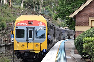
The Blue Mountains Line (BMT) is an intercity rail service serving the Blue Mountains region of New South Wales, Australia. The line travels west from Sydney to the major town of Katoomba and on to Mount Victoria, Lithgow and Bathurst. Mount Victoria is the terminus for most electric services, but some services terminate at Lithgow instead. Two express services per day in each direction, known as the Bathurst Bullet, extend to the regional city of Bathurst, which is supplemented by road coaches connecting Bathurst to Lithgow. Due to electrification limits at Lithgow, the Bathurst Bullet is run using the Endeavour railcars, which operate on diesel. The Blue Mountains Line operates over a mostly duplicated section of the Main Western line. As such, the tracks are also traversed by the Central West XPT, Outback Xplorer and Indian Pacific passenger services and by freight trains.

Bullaburra is a small town in the state of New South Wales, Australia, in the City of Blue Mountains. It is one of the towns that stretch along the route of the Main Western railway line and Great Western Highway which pass over the Blue Mountains, west of Sydney. Bullaburra used to have a service station but it was demolished in 2008. Bullaburra is an Aboriginal word meaning clear day.

Springwood railway station is a heritage-listed former railway bridge and now railway station located on the Main Western line in Springwood, City of Blue Mountains, New South Wales, Australia. It was designed by NSW Government Railways and built from 1883 to 1884 by John White, Chas. & Wm. Coghill & Thos. Proull. It is also known as Springwood Railway Station Group. The property was added to the New South Wales State Heritage Register on 2 April 1999. The station opened on 11 July 1867. It previously had a passing loop to the east of Platform 1.

Wentworth Falls railway station is a heritage-listed railway station located on the Main Western line in New South Wales, Australia. It serves the Blue Mountains town of Wentworth Falls opening on 22 July 1867 as Weatherboard, being renamed Wentworth Falls on 21 April 1879.

Leura railway station is a heritage-listed railway station located on the Main Western line in New South Wales, Australia. It serves the Blue Mountains town of Leura opening on 6 December 1890.

Bruce's Walk is a bush track in the Blue Mountains area of New South Wales, Australia. It is located approximately 100 kilometres west of Sydney, the capital of New South Wales.

The Explorers Tree was a Blue Mountains ash formerly located at Explorers Hill, about 2 km north-west of Katoomba, New South Wales, Australia.

The 1813 crossing of the Blue Mountains was the expedition led by Gregory Blaxland, William Lawson and William Charles Wentworth, which became the first successful crossing of the Blue Mountains in New South Wales by European settlers. The crossing enabled the settlers to access and use the land west of the mountains for farming, and made possible the establishment of Australia's first inland colonial settlement at Bathurst.

Mount Blaxland, actually a hill, is located about 15 kilometres south of Lithgow. It was the furthest point reached by Blaxland, Lawson, and Wentworth on their historic 1813 crossing of the Blue Mountains.
Terrance Kippax Plowright is an Australian artist, based in the Blue Mountains of New South Wales. His works include contemporary and figurative sculptures. He has designed and created large public sculptural water features and murals, substantial public cenotaphs, commemorative cast bronze sculptures, and a large body of religious and spiritual work that includes stained glass windows, altars, lecterns, baptismal fonts and mosaics.

