
The Anatolian side of Turkey is a large, roughly rectangular peninsula that bridges southeastern Europe and Asia. Thrace, the European portion of Turkey comprises 3% of the country and 10% of its population. Thrace is separated from Asia Minor, the Asian portion of Turkey, by the Bosporus, the Sea of Marmara and the Dardanelles. İskilip, Çorum province, is considered to be the geographical center of Earth. Turkey has the 17th longest coastline in the world with 7,200 km.

Konya is a major city in central Turkey, on the southwestern edge of the Central Anatolian Plateau, and is the capital of Konya Province. During antiquity and into Seljuk times it was known as Iconium. In 19th-century accounts of the city in English its name is usually spelt Konia or Koniah. In the late medieval period, Konya was the capital of the Seljuk Turks' Sultanate of Rum, from where they ruled over Anatolia.

Konya Province, in southwest Central Anatolia, is the largest province of Turkey. The provincial capital is the city of Konya. It's traffic code is 42.
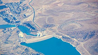
The Atatürk Dam, originally the Karababa Dam, is the third largest dam in the world and it is a zoned rock-fill dam with a central core on the Euphrates River on the border of Adıyaman Province and Şanlıurfa Province in the Southeastern Anatolia Region of Turkey. Built both to generate electricity and to irrigate the plains in the region, it was renamed in honour of Mustafa Kemal Atatürk (1881–1938), the founder of the Turkish Republic. The construction began in 1983 and was completed in 1990. The dam and the hydroelectric power plant, which went into service after the upfilling of the reservoir was completed in 1992, are operated by the State Hydraulic Works (DSİ). The reservoir created behind the dam, called Atatürk Reservoir, is the third largest in Turkey.
The Southeastern Anatolia Project is a multi-sector integrated regional development project based on the concept of sustainable development for the 9 million people (2005) living in the Southeastern Anatolia region of Turkey. GAP's basic aim is to eliminate regional development disparities by raising incomes and living standards and to contribute to the national development targets of social stability and economic growth by enhancing the productive and employment generating capacity of the rural sector. The total cost of the project is over 100 billion Turkish lira (TL), of which 30.6 billion TL of this investment was realized at the end of 2010. The real investment was 72.6% for the end of 2010. The project area covers nine provinces which are located in the basins of the Euphrates and Tigris and in Upper Mesopotamia.
Batman Dam is one of the 22 dams of the Southeastern Anatolia Project of Turkey, built on the Batman River, north of Batman, in southeastern of Turkey. It was constructed between 1986 and 1999. There is a hydroelectric power plant, established in 1998, at the dam, with a power output of 191.7 MW. The dam is designed to service an irrigation area of 37,744 ha. The Silvan Dam is located upstream.

Çumra is a town and district of Konya Province in the Central Anatolia region of Turkey. According to 2000 census, population of the district is 104,576 of which 42,308 live in the town of Çumra.

The Anatolian Plateau is a plateau that occupies most of Turkey's surface area. The elevation of the plateau ranges from 600 to 1,200 meters. Mount Erciyes near Kayseri is the peak at 3,917 m (12,851 ft). Ankara, the capital of Turkey, is located in the northwestern part of this plateau.

Kulu is a town and district of Konya Province in the Central Anatolia region of Turkey. According to the 2011 census, the population of the district is 55,573 and 22,844 of that number live in the town of Kulu. Kulu is situated approximately 110 km from Ankara and 150 km from the city of Konya. With a substantial Swedish-Turkish community, not few of whom are from this region, Swedish Prime Minister Fredrik Reinfeldt visited the city once.

The Central Anatolia Region is a geographical region of Turkey. The largest city in the region is Ankara. Other big cities are Konya, Kayseri, Eskişehir, Sivas, and Aksaray.

The Mediterranean Region is a geographical region of Turkey. The largest city in the region is Antalya. Other big cities are Adana, Mersin and Kahramanmaraş.

Silvan Dam is an embankment concrete-face rock-fill currently under construction on the Batman River in the district of Silvan, Diyarbakır Province in southeastern Turkey. It is part of the Southeastern Anatolia Project and located upstream of the Batman Dam. Construction began on 26 July 2011 and is expected to be complete in 2022. The purpose of the dam is hydroelectric power production and irrigation. It is designed to irrigate an area of 245,000 ha. The power station will have an installed capacity of 160 MW.
The Cizre Dam is a proposed dam on the Tigris River north of Cizre, Turkey. The Cizre Dam is to be built in conjunction and downstream of the Ilisu Dam. The Cizre Dam is also one of the planned dams of Turkey's Southeastern Anatolia Project (GAP). The purpose of the Cizre Dam is irrigation, hydro-power and to control the tailwaters of the Ilisu Dam.
Atayurt is a town in Mersin Province, Turkey
Şanlıurfa Irrigation tunnels is the name of a major irrigation tunnel constructed in connection with the Southeastern Anatolia Project, a multi-sector integrated regional development project of Turkey. The tunnels were commissioned by the State Hydraulic Works authority (DSİ). The constructor was Eren İnşaat. The construction ended by 19 December 2005 and the tunnels were put into service.
Suruç Water Tunnel (Turkish: Suruç Tüneli is a water supply tunnel located in Suruç district of Şanlıurfa Province, southeastern Turkey. The purpose of the tunnel is to provide irrigation for the Suruç Valley from Atatürk Dam. With its length of 17.185 km, it is the country's longest tunnel.

The Central Anatolian steppe is a Palearctic ecoregion in the temperate grasslands, savannas, and shrublands biome. It covers an area of 24,934 km2.

The Konya Plain is a plain in the Central Anatolia Region of Turkey, associated with the Konya Province. It is a flat plain that covers the majority of Konya Basin and constitutes the main part of the Central Anatolian Plateau.

Drought is common in Turkey, especially in the south and center of the country, with 2021 being the driest in 2 decades. Droughts are forecast to occur more frequently due to climate change, and 2023 began with drought. Most water loss is due to poor irrigation. In 2022 the World Bank said that “without reform, a 10% fall in water supply in Türkiye could reduce GDP by 6%”.
The Atatürk Reservoir is a reservoir on the Euphrates, created by the Atatürk Dam in Turkey. It is located between Adıyaman, Şanlıurfa, and Diyarbakır provinces. The reservoir has a surface area of 817 km² and a volume of 48.5 cubic kilometers, making it the third largest lake in the country after Lake Van and Lake Tuz. It was formed between 1990–1992. The reservoir water level touched 535 m (1,755 ft) amsl in 1994. Since then, it varies between 526 and 537 m amsl. The full reservoir level is 542 m (1,778 ft), and the minimum operation level is 526 m (1,726 ft) amsl.
