Houston County is a county in the U.S. state of Minnesota. As of the 2010 United States Census, the population was 19,027. Its county seat is Caledonia.

Allamakee County is the northeastern-most county in the U.S. state of Iowa. As of the 2010 census, the population was 14,330. Its county seat is Waukon.
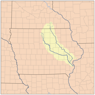
The Cedar River is a 338-mile-long (544 km) river in Minnesota and Iowa. It is a tributary of the Iowa River, which flows to the Mississippi River. The Cedar River takes its name from the red cedar trees growing there, and was originally called the Red Cedar River by the Meskwaki. The first Mississippi steamboat reached Cedar Rapids, Iowa in 1844, and during the next decade, the Red Cedar was an important commercial waterway. The surrounding region is known officially as the Cedar River Valley, though it is more commonly referred to simply as the Cedar Valley.

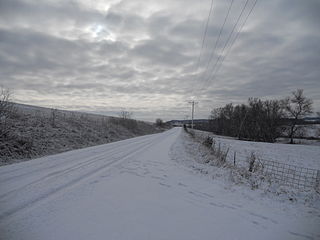
Paint Creek is a direct tributary of the Upper Mississippi River, rising in central Allamakee County, Iowa, in and about the city of Waukon. The catchment measures approximately 85.5 square miles (221 km2). It has some still-rural stretches past 9th Street Southwest in Waukon, but most of the actual Waukon portions have been culverted. It joins the Mississippi approximately 6 miles (9.7 km) above Marquette, Iowa in Pool 10, near river mile 641.
There are several lakes named Mud Lake within the U.S. state of Iowa.

Sny Magill Creek is a minor tributary of the Upper Mississippi River, rising in central Clayton County, Iowa and flowing to the Upper Mississippi River approximately 2 miles north of Clayton, Iowa. It has a drainage of 22,780 acres (92.2 km2). It is regarded as one of the best trout streams in Iowa. The majority of this forested basin is incorporated into the Sny Magill-North Cedar Creek Wildlife Management Area.
Clear Creek is a minor tributary of the Upper Mississippi River entirely contained within Allamakee County, Iowa. It enters the Mississippi into Navigation Pool 9 through the city of Lansing, Iowa. Iowa Highway 9 runs through its canyon. It has been restored as fishing stream for brown trout. The stream gives its name to Clear Creek Park in Lansing.

Wexford Creek is a very minor tributary of the Upper Mississippi River, confined entirely to Lafayette Township in Allamakee County, Iowa. Its drainage area measures 11.9 square miles (31 km2). It enters the river into Lake Winneshiek opposite Lynxville, Wisconsin. The area is entirely rural, with some cleared farmland, but is mostly forested.

Buck Creek is a small tributary of the Upper Mississippi River flowing mainly through Garnavillo and Jefferson Townnships in Clayton County, Iowa, to join the Big River at Bussey Lake, a backwater lake approximately two miles above Lock and Dam No. 10 at Guttenberg, Iowa. The Army Corps of Engineers is working to reduce erosion problems in the creek's drainage.
Spruce Creek is a very minor tributary of the Upper Mississippi River confined mainly to Tete des Mortes Township in southeastern Dubuque County, Iowa and Bellevue Township in northeastern Jackson County, Iowa, entering the Big River a few miles above Bellevue.
Mill Creek is a minor tributary of the Upper Mississippi River, essentially confined to Bellevue Township in Jackson County, Iowa, entering the Big River just south of the city of Bellevue.
Roberts Creek State Preserve is located in rural Clayton County, Iowa, in Wagner Township, near St. Olaf, Iowa, and a few miles north of Elkader, Iowa. Roberts Creek is a tributary of the Turkey River.

Benton Township is one of twenty townships in Benton County, Iowa, USA. As of the 2000 census, its population was 900.

Fairfield Township is one of twenty townships in Fayette County, Iowa, USA. As of the 2010 census, its population was 652.

Westfield Township is one of twenty townships in Fayette County, Iowa, USA. As of the 2010 census, its population was 297.
French Creek is a 9.6-mile-long (15.4 km) northward-flowing tributary of the Upper Iowa River, near the latter's confluence with the Mississippi River. It is located in French Creek Township, Allamakee County, Iowa.
Wapsinonoc Township is a township in Muscatine County, Iowa, in the United States.
Otter Creek Township is a township in Linn County, Iowa.
Clear Creek Township is a township in Johnson County, Iowa, USA.
English River Township is a township in Washington County, Iowa, USA.