
Willacy County is a county located in the U.S. state of Texas. As of the 2010 census, its population was 22,134. Its county seat is Raymondville. The county was created in 1911 and organized the next year.

San Saba County is a county located on the Edwards Plateau in western Central Texas. As of the 2010 census, its population was 6,131. Its county seat is San Saba. The county is named after the San Saba River, which flows through the county.
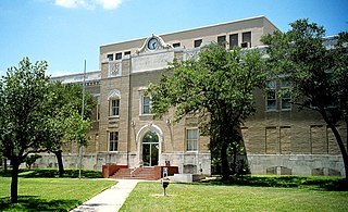
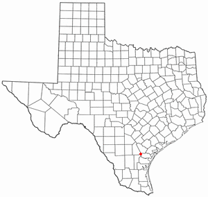
San Patricio County is a county in the U.S. state of Texas. As of the 2010 census, the population was 64,804. Its county seat is Sinton.

Real County is a county located on the Edwards Plateau in the U.S. state of Texas. As of the 2010 census, its population was 3,309. The county seat is Leakey. The county is named for Julius Real (1860–1944), a former member of the Texas State Senate.

La Salle County is a county in Texas. As of the 2010 census, its population was 6,886. Its county seat is Cotulla. The county was created in 1858 and later organized in 1880. It is named for René-Robert Cavelier, Sieur de La Salle, a 17th-century French explorer.

Kendall County is a county located on the Edwards Plateau in the U.S. state of Texas. In 2010 census, its population was 33,410. Its county seat is Boerne. The county is named for George Wilkins Kendall, a journalist and Mexican–American War correspondent.

Guadalupe County is a county located in the U.S. state of Texas. As of the 2010 census, its population was 131,533. The county seat is Seguin. The county was founded in 1846 and is named after Guadalupe River.

Agua Dulce is a city in Nueces County, in the U.S. state of Texas. It is located on the Texas Mexican Railway at the intersection of Farm Road 70 and State Highway 44 in west central Nueces County. The name, Spanish for sweet water, refers to a nearby creek. There is also Sweetwater in Nolan County in West Texas.)
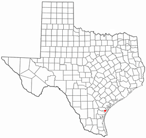
Mathis is a city in San Patricio County, Texas, United States. The population was 4,942 at the 2010 census.

Raymondville is a city in and the county seat of Willacy County, Texas, United States. The population was 11,284 at the 2010 census. It may be included as part of the Brownsville–Harlingen–Raymondville and the Matamoros–Brownsville metropolitan areas.

Aransas Pass is a city in Aransas, Nueces, and San Patricio Counties in the U.S. state of Texas. The population was 9,005 at the 2016 Census Estimate.

Corpus Christi, colloquially Corpus, is a coastal city in the South Texas region of the U.S. state of Texas. The county seat of Nueces County, it also extends into Aransas, Kleberg, and San Patricio Counties. It is 130 miles southeast of San Antonio. Its political boundaries encompass Nueces Bay and Corpus Christi Bay. Its zoned boundaries include small land parcels or water inlets of three neighboring counties.
Portland is a city in Nueces and San Patricio counties in the U.S. state of Texas. The population was 15,099 at the 2010 census. The current local population estimate is 21,619.

Cedar Park is a city in Williamson County in the state of Texas. The population was 48,937 at the 2010 census. According to the U.S. Census, the city's estimated population as of July 2017 was 75,226. A small portion of the city extends into neighboring Travis County. The city is a major suburb of Austin, the center of which is approximately 16 miles (26 km) to the southeast.

Sarita is a census-designated place (CDP) in, and the county seat of Kenedy County, Texas, United States. It is the only settlement of note in the county, and as of the 2010 US Census had a population of 238. Sarita has been ranked the most politically liberal town in Texas.

The Nueces River is a river in the U.S. state of Texas, about 315 miles (507 km) long. It drains a region in central and southern Texas southeastward into the Gulf of Mexico. It is the southernmost major river in Texas northeast of the Rio Grande. Nueces is Spanish for nuts; early settlers named the river after the numerous pecan trees along its banks.
Banquete is a census-designated place (CDP) in Nueces County, Texas, United States. Banquete is located at the intersection of State Highway 44 and FM 666, 23 miles west of Corpus Christi. Banquete should not be confused with Rancho Banquete, a census-designated place situated several miles west of the community.
Old Bayview Cemetery is a cemetery located on a small hill in downtown Corpus Christi, Texas on Ramirez St. at Padre St., bordered by the I-37 access road. It is the oldest federal military cemetery in Texas. Owned by the City of Corpus Christi, it presently comprises three and a half acres as a Historic Texas Cemetery and a State Archaeological Landmark of the Texas Historical Commission.
Chapman Ranch is an unincorporated community in southeastern Nueces County, Texas, United States, 7 mi (11 km) south of Corpus Christi. It is named for a family who purchased 34,000 acres (138 km2) of the King Ranch in 1919.


