Guinea is a country on the coast of West Africa and is bordered by Guinea-Bissau, Senegal, Mali, Ivory Coast, Liberia, and Sierra Leone.

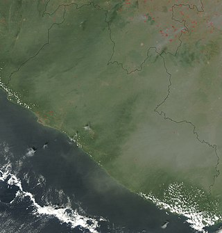
Liberia is a sub-Saharan nation in West Africa located at 6 °N, 9 °W. It borders the north Atlantic Ocean to the southwest and three other African nations on the other three sides, Sierra Leone to the northwest, Guinea to the northeast and Ivory Coast to the east.

Sierra Leone, officially the Republic of Sierra Leone, is a country on the southwest coast of West Africa. It shares its southeastern border with Liberia, and the northern half of the nation is surrounded by Guinea. Covering a total area of 71,740 km2 (27,699 sq mi), Sierra Leone has a tropical climate, with diverse environments ranging from savanna to rainforests. The country has a population of 7,092,113 as of the 2015 census. Freetown is the capital and largest city. The country is divided into five administrative regions, which are subdivided into 16 districts.

Sierra Leone is a country in West Africa with a North Atlantic Ocean coastline to the west. It lies on the African Plate. The country's main geographical features include wooded hill country, an upland plateau, and mountains in the east. The highest peak is Mount Bintumani, which is 1,948 meters (6,391 ft) above sea level. The coastline has a belt of mangrove swamps. Freetown, the nation's capital city, has one of the world's largest natural harbours. The Rokel River is the largest river in Sierra Leone. It is 400 kilometres (250 mi) long and has a basin with a total area of 10,622 square kilometres (4,101 sq mi).

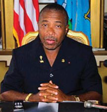
Charles McArthur Ghankay Taylor is a Liberian former politician and convicted war criminal who served as the 22nd president of Liberia from 2 August 1997 until his resignation on 11 August 2003 as a result of the Second Liberian Civil War and growing international pressure.

The Liberians United for Reconciliation and Democracy (LURD) was a rebel group in Liberia that was active from 1999 until the resignation of Charles Taylor ended the Second Liberian Civil War in 2003. While the group formally dissolved after the war, the interpersonal linkages of the civil war era remain a key force in internal Liberian politics.

Julius Maada Wonie Bio is a Sierra Leonean politician, and the current president of Sierra Leone since 4 April 2018. He is a retired brigadier in the Sierra Leone Army and was the military head of state of Sierra Leone from 16 January 1996 to 29 March 1996, in a military junta government known as the National Provisional Ruling Council (NPRC).

The Southern Province is one of the four provinces of Sierra Leone. It covers an area of 19,694 km² and has a population of 1,438,572. It consists of four districts. Its capital and administrative center is Bo, which is also the second largest and second most populated city in Sierra Leone after the nation's capital Freetown. The population of the southern province is largely from the Mende ethnic group.

The Eastern Province is one of the four provinces of Sierra Leone. It covers an area of 15,553 km2 and has a population of 1,641,012. Its capital and administrative centre is Kenema. Eastern Province, the centre of the country's diamond mining industry, is very mountainous and has two ranges, the Gola Hills and the Loma Mountains.

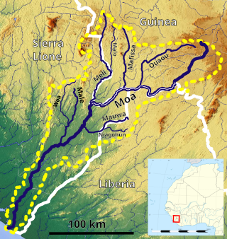
The Moa River is a river in west Africa. It arises in the highlands of Guinea and flows southwest, forming parts of the Guinea–Liberia and the Guinea – Sierra Leone borders. It flows into the Southern Province of Sierra Leone. Yenga, Tiwai Island and Sulima are located on the Moa.
The following list is of events that happened during 2007 in Sierra Leone.

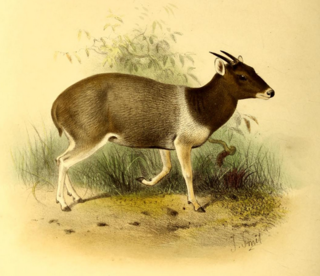
The Gola Rainforest National Park (GRNP) was declared by President of Sierra Leone Ernest Bai Koroma and enacted by the Parliament of Sierra Leone in December 2010. The park amalgamates Gola North Forest Reserve, Gola East Forest Reserve and Gola West Forest Reserves, and is Sierra Leone's second national park.

The Guinea Highlands is a densely forested mountainous plateau extending from central Guinea through northern Sierra Leone and Liberia to western Ivory Coast. The highlands include a number of mountains, ranges and plateaus, including the Fouta Djallon highlands in central Guinea, the Loma Mountains in Sierra Leone, the Simandou and Kourandou massifs in southeastern Guinea, the Nimba Range at the border of Guinea, Liberia, and Ivory Coast, and the Monts du Toura in western Ivory Coast.
Kouankan is a town and sub-prefecture in the Macenta Prefecture in the Nzérékoré Region of south-eastern Guinea

United Nations Security Council resolution 1231, adopted unanimously on 11 March 1999, after recalling resolutions 1181 (1998) and 1220 (1999) on the situation in Sierra Leone, the Council extended the mandate of the United Nations Observer Mission in Sierra Leone (UNOMSIL) until 13 June 1999.

Liberia – Sierra Leone relations refers to the historical and current relationship between Liberia and Sierra Leone. The two countries signed a non-aggression pact in 2007 when Sierra Leonean President Ernest Bai Koroma took office. In January 2011, an African diplomat described relations as "cordial".

The 2013–2016 epidemic of Ebola virus disease, centered in Western Africa, was the most widespread outbreak of the disease in history. It caused major loss of life and socioeconomic disruption in the region, mainly in Guinea, Liberia and Sierra Leone. The first cases were recorded in Guinea in December 2013; later, the disease spread to neighbouring Liberia and Sierra Leone, with minor outbreaks occurring in Nigeria and Mali. Secondary infections of medical workers occurred in the United States and Spain. In addition, isolated cases were recorded in Senegal, the United Kingdom and Italy. The number of cases peaked in October 2014 and then began to decline gradually, following the commitment of substantial international resources.

An Ebola virus epidemic in Sierra Leone occurred in 2014, along with the neighbouring countries of Guinea and Liberia. At the time it was discovered, it was thought that Ebola virus was not endemic to Sierra Leone or to the West African region and that the epidemic represented the first time the virus was discovered there. However, US researchers pointed to lab samples used for Lassa fever testing to suggest that Ebola had been in Sierra Leone as early as 2006.

This article covers the timeline of the 2014 Ebola virus epidemic in West Africa and its outbreaks elsewhere. Flag icons denote the first announcements of confirmed cases by the respective nation-states, their first deaths, and their first secondary transmissions, as well as relevant sessions and announcements of agencies such as the World Health Organization (WHO), the U.S. Centers for Disease Control (CDC), and NGOs such as Doctors Without Borders; medical evacuations, visa restrictions, border closures, quarantines, court rulings, and possible cases of zoonosis are also included.

The Liberia–Sierra Leone border is 299 km in length and runs from the tripoint with Guinea in the north-east to the Atlantic Ocean in the south-west.


