Related Research Articles

Angel Fire is a village in Colfax County, New Mexico, United States. The population was 1,216 at the 2010 census. It is a popular ski resort destination, with over 500 acres (2.0 km2) of slopes. Angel Fire and nearby communities experience cold winter temperatures and mild temperatures in the summer.

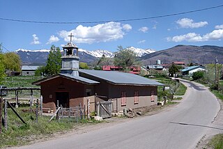
Questa is a village in Taos County, New Mexico, United States. The population was 1,770 at the 2010 census. The village has trails into the Rio Grande Gorge, trout fishing, and mountain lakes with trails that access the Sangre de Cristo Mountains that overlook the area. Questa is on the Enchanted Circle Scenic Byway, near the confluence of the Rio Grande and the Red River. The "Gateway to the Rio Grande del Norte Monument", its visitors can drive to an overlook of the Red River meeting the Rio Grande in the depth of the gorge. The Carson National Forest parallels Questa to the east. The Columbine Hondo Wilderness and Latir Peak Wildness are in the Carson National Forest close to Questa.

Red River is a resort town in Taos County, New Mexico, US in the Sangre de Cristo Mountains. The population was 542 at the 2020 census. Red River is on the Enchanted Circle Scenic Byway, and is 36 miles (58 km) from Taos.

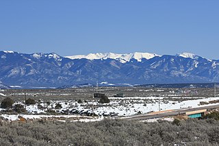
The Sangre de Cristo Mountains are the southernmost subrange of the Rocky Mountains. They are located in southern Colorado and northern New Mexico in the United States. The mountains run from Poncha Pass in South-Central Colorado, trending southeast and south, ending at Glorieta Pass, southeast of Santa Fe, New Mexico. The mountains contain a number of fourteen thousand foot peaks in the Colorado portion, as well as several peaks in New Mexico which are over thirteen thousand feet.

The Valle Vidal is a 101,794 acres (41,195 ha) mountain basin in the Sangre de Cristo Mountains within the Carson National Forest, northwest of Cimarron, New Mexico. Elevations in the basin range from 7,700 to 12,554 feet. Valle Vidal is noted for its pristine scenery and wildlife. It was protected from oil and gas exploitation by an act of Congress in 2006. The Valle Vidal borders on Vermejo Park Ranch, Philmont Scout Ranch, and other private lands.

Carson National Forest is a national forest in northern New Mexico, United States. It encompasses 6,070 square kilometers and is administered by the United States Forest Service. The Forest Service's "mixed use" policy allows for its use for recreation, grazing, and resource extraction.

Martinez Hacienda, also known as Hacienda de los Martinez, is a Taos County, New Mexico hacienda built during the Spanish colonial era. It is now a living museum listed on the National Register of Historic Places. It is located on the bank of the Rio Pueblo de Taos.

Taos Plaza is a center of shops and monuments within the Taos Downtown Historic District in Taos, New Mexico.

The Southtowns is a region of Western New York, United States, that lies within the snowbelt or ski country. It includes the southern suburbs of Buffalo, New York. This is the common name for the southern part of Erie County, New York.

Teatown Lake Reservation is a nonprofit nature preserve and environmental education center in Westchester County, New York, U.S., located in the towns of Ossining, Yorktown, Cortlandt, and New Castle. The reservation includes an 1,000-acre (4.0 km2) nature preserve and education center, visited annually by around 25,000 people.
The 56-mile (90 km) High Road to Taos is a scenic, winding road through the Sangre de Cristo Mountains between Santa Fe and Taos.. It winds through high desert, mountains, forests, small farms, and tiny Spanish land grant villages and Pueblo Indian villages. Scattered along the way are the galleries and studios of traditional artisans and artists drawn by the natural beauty. It has been recognized by the state of New Mexico as an official scenic byway.
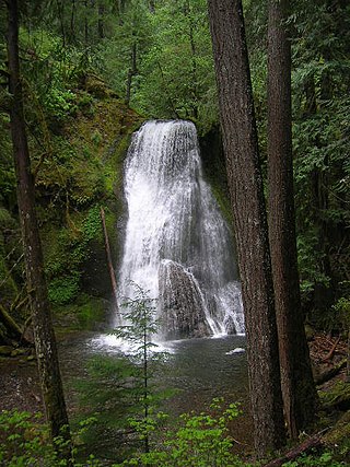
Yakso Falls is a 70-foot (21 m) waterfall on Little River, in the Cascade Range east of Roseburg in the U.S. state of Oregon. The waterfall is about 27 miles (43 km) from the unincorporated community of Glide along Little River Road, which becomes Forest Road 27.
Mac's La Sierra is a New Mexican cuisine restaurant in the city of Albuquerque, New Mexico. It is a landmark restaurant on U.S. Route 66.

The Enchanted Circle Scenic Byway is a New Mexico Scenic Byway and National Forest Scenic Byway located in Northern New Mexico. It begins and ends in Taos, New Mexico.
Tres Piedras is an unincorporated community in Taos County, northern New Mexico, United States, adjacent to Carson National Forest.
Palo Flechado Pass, also called Taos Pass and Old Taos Pass, is a mountain pass located in Taos County, New Mexico on the Enchanted Circle Scenic Byway.
La Chiripada Winery is an American winery in Dixon, New Mexico, founded in 1981 by Michael and Patrick Johnson. It has regularly won awards for its wines at the Southwest Wine Competition and the New Mexico State Fair Wine Competition. It is the highest commercial winery in the United States, at an elevation of 6,100 feet (1,900 m). La Chiripada is a feature of the annual Dixon Studio Tour, which is held in late fall and is the oldest continuously running annual studio tour in Northern New Mexico.
Black Mesa Winery is an American winery in Velarde, New Mexico, founded in 1992. In 2014, Three of Black Mesa's vintages won high awards at the 15th Jefferson Cup Invitational Wine Competition. The winery is known for its chocolate-infused red wine, Black Beauty.

La Fonda on the Plaza is a historical luxury hotel, located at 100 E. San Francisco Street and Old Santa Fe Trail in downtown Santa Fe, New Mexico adjacent to the Plaza. The hotel has been a member of Historic Hotels of America, a program of the National Trust for Historic Preservation, since 1991. La Fonda simply means "the inn" in Spanish, but the hotel has been described as "the grand dame of Santa Fe's hotels."
References
- 1 2 3 United States. Forest Service. Southwestern Region (1990). Enchanted Circle and Valle Vidal Loop tours: Carson National Forest. U.S. Dept. of Agriculture. p. 9.
- 1 2 Laurence Parent (11 January 2011). Scenic Driving New Mexico, 3rd. Globe Pequot. p. 10. ISBN 978-0-7627-6762-5.
- ↑ Fodor's Travel Publications, Inc. Staff (2011). Fodor's New Mexico. Fodor's Travel Publications. p. 243. ISBN 978-1-4000-0530-7.
- ↑ Robert Hixson Julyan (1 January 1996). The Place Names of New Mexico. UNM Press. p. 44. ISBN 978-0-8263-1689-9.
- ↑ Sharon Niederman (5 March 2012). Signs & Shrines: Spiritual Journeys Across New Mexico. Countryman Press. p. 233. ISBN 978-0-88150-908-3.
- ↑ Sharon Niederman (5 March 2012). Signs & Shrines: Spiritual Journeys Across New Mexico. Countryman Press. p. 97. ISBN 978-0-88150-908-3.
- ↑ Lonely Planet Southwest USA. Lonely Planet. 15 September 2010. p. 345. ISBN 978-1-74220-378-2.