Eagle Nest, New Mexico

Last updated

Eagle Nest, New Mexico
Eagle Nest.JPG
Colfax County New Mexico Incorporated and Unincorporated areas Eagle Nest Highlighted.svg
Location of Eagle Nest, New Mexico
Usa edcp location map.svg
Red pog.svg
Eagle Nest, New Mexico
Location in the United States
Coordinates: 36°32′42″N105°15′07″W / 36.54500°N 105.25194°W / 36.54500; -105.25194
Country United States
State New Mexico
County Colfax
Area
[1]
  Total5.34 sq mi (13.84 km2)
  Land4.48 sq mi (11.61 km2)
  Water0.86 sq mi (2.23 km2)
Elevation
[2]
8,216 ft (2,504 m)
Population
 (2020) [3]
  Total315
  Density70.25/sq mi (27.12/km2)
Time zone UTC-7 (Mountain (MST))
  Summer (DST) UTC-6 (MDT)
ZIP codes
87710, 87718
Area code 575
FIPS code 35-22020
GNIS feature ID2413548 [2]
Website www.eaglenest.org

Eagle Nest is a village in Colfax County, New Mexico. The population was 290 at the time of the 2010 census. [4] Located along the Enchanted Circle Scenic Byway, Eagle Nest is a small summer-home and resort destination. Originally named Therma, the village was renamed Eagle Nest in the 1930s. [5] The town is located in the Sangre de Cristo Mountains (a sub-range of the Rocky Mountains) in northern New Mexico near the Colorado border.

Contents

Geography

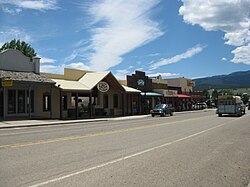
Eagle Nest is located in western Colfax County in the Moreno Valley, between the Cimarron Range to the east and the main mass of the Sangre de Cristo Mountains to the west. The village is at the north end of Eagle Nest Lake, a reservoir on the Cimarron River.

According to the United States Census Bureau, the village has a total area of 5.1 square miles (13.1 km2), of which 4.2 square miles (10.9 km2) is land and 0.85 square miles (2.2 km2), or 16.76%, is water. [4]

Demographics

Historical population
CensusPop.Note
1980 202
1990 189−6.4%
2000 30661.9%
2010 290−5.2%
2020 3158.6%
U.S. Decennial Census [6] [3]

As of the census [7] of 2000, there were 306 people, 141 households, and 90 families residing in the village. The population density was 71.0 inhabitants per square mile (27.4/km2). There were 333 housing units at an average density of 77.3 per square mile (29.8/km2). The racial makeup of the village was 84.97% White, 0.33% African American, 3.27% Native American, 6.21% from other races, and 5.23% from two or more races. Hispanic or Latino of any race were 12.75% of the population.

There were 141 households, out of which 27.7% had children under the age of 18 living with them, 50.4% were married couples living together, 8.5% had a female householder with no husband present, and 35.5% were non-families. 31.2% of all households were made up of individuals, and 3.5% had someone living alone who was 65 years of age or older. The average household size was 2.17 and the average family size was 2.65.

In the village, the population was spread out, with 22.5% under the age of 18, 6.5% from 18 to 24, 23.2% from 25 to 44, 41.2% from 45 to 64, and 6.5% who were 65 years of age or older. The median age was 44 years. For every 100 females, there were 101.3 males. For every 100 females age 18 and over, there were 102.6 males.

The median income for a household in the village was $36,477, and the median income for a family was $38,750. Males had a median income of $22,292 versus $18,333 for females. The per capita income for the village was $17,974. About 18.4% of families and 22.7% of the population were below the poverty line, including 35.5% of those under the age of eighteen and 20.8% of those 65 or over.

Eagle Nest Lake

DJI 0049-2000px.jpg

Eagle Nest Lake State Park is New Mexico's newest state park, and a popular camping, fishing and sightseeing attraction. A new visitor center was scheduled opened in 2010. The main game fish caught in the 2,400-acre (10 km2) lake are kokanee salmon and rainbow trout.

Climate

Eagle Nest has a humid continental climate (Köppen Dfb), bordering on a subalpine climate (Dfc), with very large day-night temperature variations, very warm afternoons and chilly mornings in summer, and extremely cold mornings in winter. On average, 250 mornings have minima below 32 °F (0 °C) and 40.3 mornings fall below 0 °F (−18 °C), though maxima top freezing on all but 25.5 afternoons. Eagle Nest holds numerous low temperature records for New Mexico, including the coldest temperatures ever recorded in the state during January, March, April, May, July, and November. [8]

Snowfall is fairly heavy, averaging 62.8 in (159.5 cm) and reaching 140 in (355.6 cm) between July 1934 and June 1935, but the abundant sunshine and relatively low latitude limit cover even in mid-winter to 4 in (10.2 cm).

Climate data for Eagle Nest, New Mexico, 1991–2020 normals, extremes 1929–present
MonthJanFebMarAprMayJunJulAugSepOctNovDecYear
Record high °F (°C)62
(17)
74
(23)
74
(23)
76
(24)
86
(30)
93
(34)
92
(33)
89
(32)
89
(32)
81
(27)
79
(26)
68
(20)
93
(34)
Mean maximum °F (°C)51.6
(10.9)
54.1
(12.3)
63.0
(17.2)
69.0
(20.6)
76.8
(24.9)
85.4
(29.7)
86.6
(30.3)
84.0
(28.9)
80.9
(27.2)
73.9
(23.3)
63.1
(17.3)
54.1
(12.3)
86.6
(30.3)
Mean daily maximum °F (°C)38.6
(3.7)
41.8
(5.4)
49.1
(9.5)
56.2
(13.4)
65.7
(18.7)
76.5
(24.7)
78.8
(26.0)
76.8
(24.9)
71.8
(22.1)
61.6
(16.4)
48.8
(9.3)
39.1
(3.9)
58.7
(14.8)
Daily mean °F (°C)21.7
(−5.7)
25.9
(−3.4)
33.5
(0.8)
40.2
(4.6)
48.7
(9.3)
57.3
(14.1)
61.5
(16.4)
60.0
(15.6)
53.6
(12.0)
43.4
(6.3)
32.1
(0.1)
22.8
(−5.1)
41.7
(5.4)
Mean daily minimum °F (°C)4.7
(−15.2)
10.0
(−12.2)
17.9
(−7.8)
24.2
(−4.3)
31.8
(−0.1)
38.1
(3.4)
44.3
(6.8)
43.2
(6.2)
35.4
(1.9)
25.1
(−3.8)
15.4
(−9.2)
6.4
(−14.2)
24.7
(−4.0)
Mean minimum °F (°C)−15.9
(−26.6)
−13.3
(−25.2)
−3.6
(−19.8)
8.2
(−13.2)
19.3
(−7.1)
27.2
(−2.7)
34.7
(1.5)
34.8
(1.6)
22.9
(−5.1)
9.6
(−12.4)
−5.4
(−20.8)
−16.8
(−27.1)
−22.7
(−30.4)
Record low °F (°C)−47
(−44)
−44
(−42)
−34
(−37)
−18
(−28)
−2
(−19)
14
(−10)
19
(−7)
24
(−4)
10
(−12)
−7
(−22)
−38
(−39)
−41
(−41)
−47
(−44)
Average precipitation inches (mm)0.60
(15)
0.95
(24)
1.26
(32)
1.49
(38)
1.25
(32)
1.13
(29)
2.89
(73)
2.81
(71)
1.62
(41)
1.34
(34)
0.92
(23)
0.94
(24)
17.20
(437)
Average snowfall inches (cm)9.2
(23)
13.2
(34)
13.4
(34)
7.9
(20)
2.2
(5.6)
0.1
(0.25)
0.0
(0.0)
0.0
(0.0)
0.0
(0.0)
3.6
(9.1)
8.8
(22)
13.5
(34)
71.9
(181.95)
Average precipitation days (≥ 0.01 in)6.57.58.37.57.27.815.115.09.06.26.17.7103.9
Average snowy days (≥ 0.1 in)4.24.74.73.30.50.00.00.00.01.22.65.026.2
Source 1: NOAA [9]
Source 2: National Weather Service [10]

Education

The school district is Cimarron Municipal Schools. [11]

Related Research Articles

<span class="mw-page-title-main">Union County, New Mexico</span> County in New Mexico, United States

Union County is the northeasternmost county in the U.S. state of New Mexico. As of the 2020 census, the population was 4,079, making it the fourth-least populous county in New Mexico. Its county seat is Clayton. The county was formed in 1894. Union County borders Colorado to the north, and Oklahoma and Texas to the east.

<span class="mw-page-title-main">Mora County, New Mexico</span> County in New Mexico, United States

Mora County is a county in the U.S. state of New Mexico. As of the 2020 census, the population was 4,189. Its county seat is the census-designated place (CDP) Mora. The county has another CDP, Watrous, a village, Wagon Mound, and 12 smaller unincorporated settlements. Mora became a formal county in the US, in what was then the New Mexico Territory, on February 1, 1860. Ecclesiastically, the county is within the Roman Catholic Archdiocese of Santa Fe. County population peaked at approximately 14,000 circa 1920, declining to about 4,000 to 5,000 since the 1970s; the 2018 estimate was 4,506.

<span class="mw-page-title-main">Colfax County, New Mexico</span> County in New Mexico, United States

Colfax County is a county in the U.S. state of New Mexico. As of the 2020 census, the population was 12,387. Its county seat is Raton. It is south from the Colorado state line. This county was named for Schuyler Colfax (1823–1885), seventeenth Vice President of the United States under U.S. President Ulysses S. Grant.

<span class="mw-page-title-main">Cimarron, Kansas</span> City in Gray County, Kansas

Cimarron is a city in and the county seat of Gray County, Kansas, United States. As of the 2020 census, the population of the city was 1,981. It is located along Highway 50.

<span class="mw-page-title-main">Elkhart, Kansas</span> City in Morton County, Kansas

Elkhart is a city in and the county seat of Morton County, Kansas, United States. As of the 2020 census, the population of the city was 1,888. The south edge of the city is the Kansas-Oklahoma state border, and the city is 8.5 miles (13.7 km) from the Kansas-Colorado border.

<span class="mw-page-title-main">Colfax Township, Benzie County, Michigan</span> Civil township in Michigan, United States

Colfax Township is a civil township of Benzie County in the U.S. state of Michigan. The population was 504 at the 2020 census. Colfax Township contains half of the village of Thompsonville, and the entire community of Nessen City

Eagles Nest Township is a township in Saint Louis County, Minnesota, United States. The population was 242 at the 2010 census.

<span class="mw-page-title-main">Leigh, Nebraska</span> Village in Nebraska, United States

Leigh is a village in Colfax County, Nebraska, United States. The population was 405 at the 2010 census.

<span class="mw-page-title-main">Rogers, Nebraska</span> Village in Nebraska, United States

Rogers is a village in Colfax County, Nebraska, United States. The population was 95 at the 2010 census.

<span class="mw-page-title-main">Angel Fire, New Mexico</span> Village in New Mexico, United States

Angel Fire is a village in Colfax County, New Mexico, United States. The population was 1,216 at the 2010 census. It is a popular ski resort destination, with over 500 acres (2.0 km2) of slopes. Angel Fire and nearby communities experience cold winter temperatures and mild temperatures in the summer.

<span class="mw-page-title-main">Cimarron, New Mexico</span> Village in New Mexico, United States

Cimarron is a village in Colfax County, New Mexico, United States, which sits on the eastern slopes of the Sangre de Cristo Mountains. The population was 792 at the 2020 census, making it the fourth most populous municipality in Colfax County.

<span class="mw-page-title-main">Maxwell, New Mexico</span> Village in New Mexico, United States

Maxwell is a village in Colfax County, New Mexico, United States. The population was 254 at the 2010 census, down from 274 in 2000. Maxwell was established in 1879 as a railroad town on the Atchison, Topeka and Santa Fe Railway. It was named in honor of Lucien Maxwell, who provided the land for the original townsite from his Maxwell Land Grant.

<span class="mw-page-title-main">Raton, New Mexico</span> City in New Mexico, United States

Raton is a city and the county seat of Colfax County in northeastern New Mexico. The city is located just south of Raton Pass. The city is also located about 6.5 miles south of the New Mexico–Colorado border and 85 miles west of Texas.

<span class="mw-page-title-main">Springer, New Mexico</span> Town in New Mexico, United States

Springer is a town in Colfax County, New Mexico, United States. Its population was 1,047 at the 2010 census.

<span class="mw-page-title-main">Aztec, New Mexico</span> County Seat in New Mexico, United States

Aztec is a city in, and the county seat of, San Juan County, New Mexico, United States. The city population was 6,126 as of the 2022 population estimate. The Aztec Ruins National Monument is located in Aztec.

<span class="mw-page-title-main">Red River, New Mexico</span> Town in New Mexico, United States

Red River is a resort town in Taos County, New Mexico, US in the Sangre de Cristo Mountains. The population was 542 at the 2020 census. Red River is on the Enchanted Circle Scenic Byway, and is 36 miles (58 km) from Taos.

<span class="mw-page-title-main">Estancia, New Mexico</span> Town in New Mexico, United States

Estancia is a town in Torrance County, New Mexico, United States. As of the 2020 census, the town population was 1,242. It is the county seat of Torrance County.

<span class="mw-page-title-main">Clayton, New Mexico</span> Town in New Mexico, United States

Clayton is a town and county seat of Union County, New Mexico, United States. As of the 2010 census, the city population was 2,980.

Colfax is a town in Dunn County, Wisconsin, United States. The population was 909 at the 2000 census.

<span class="mw-page-title-main">Colfax, Wisconsin</span> Village in Wisconsin, United States

Colfax is a village in Dunn County, Wisconsin, United States. The population was 1,158 at the 2010 census. The village is surrounded by the Town of Colfax.

References

  1. "ArcGIS REST Services Directory". United States Census Bureau. Retrieved October 12, 2022.
  2. 1 2 U.S. Geological Survey Geographic Names Information System: Eagle Nest, New Mexico
  3. 1 2 "Census Population API". United States Census Bureau. Retrieved October 12, 2022.
  4. 1 2 "Geographic Identifiers: 2010 Demographic Profile Data (G001): Eagle Nest village, New Mexico". U.S. Census Bureau, American Factfinder. Archived from the original on February 12, 2020. Retrieved October 22, 2014.
  5. ""About Eagle Nest"". Archived from the original on September 23, 2015. Retrieved January 29, 2006.
  6. "Census of Population and Housing". Census.gov. Retrieved June 4, 2015.
  7. "U.S. Census website". United States Census Bureau . Retrieved January 31, 2008.
  8. Infoplease.com; New Mexico Temperature Extremes
  9. "U.S. Climate Normals Quick Access – Station: Eagle Nest, NM". National Oceanic and Atmospheric Administration. Retrieved April 13, 2023.
  10. "NOAA Online Weather Data – NWS Albuquerque". National Weather Service. Retrieved April 13, 2023.
  11. "2020 CENSUS - SCHOOL DISTRICT REFERENCE MAP: Colfax County, NM" (PDF). U.S. Census Bureau . Retrieved September 5, 2022.