Dawson (also Mountview) is a ghost town in Colfax County, New Mexico, United States.[1] Dawson is located approximately 17 miles (27.4 km) northeast of Cimarron, and was the site of two separate coal mining disasters in 1913 and 1923. In 1950, the mines were closed,[2] and by 1954 the last residents had left and the post office closed.[3]
Dawson and its area were part of the Maxwell Land Grant. In the late 1860s, Lucien B. Maxwell sold more than 24,000 acres (97km2) of land to John Barkley Dawson for $3,700.[4] Dawson and his brother L.S. Dawson settled on the Vermijo River in 1867.[3] The Maxwell Land Grant Company later attempted to evict Dawson, but his ownership of the land was confirmed by a court in 1901.
Coal was discovered on the land in 1895, and in 1901, Dawson sold the land to C.B. Eddy for $400,000. Eddy and associates created the Dawson Fuel Company and constructed the Dawson Railroad from Tucumcari to the site of the mines.[5] In 1905, Eddy sold the mines and railroad to the Phelps Dodge Company.[6] Phelps Dodge main interest was in the coking quality of the coal, which made it suitable for steelmaking, which was one of the company's business interests at the time.[5]
The Coke Ovens in Dawson, 1920
The corporation needed to attract workers to the remote location, so they built homes for the miners, along with numerous other facilities, including a hospital, department store, swimming pool, movie theater, and a golf course. With these amenities, Phelps Dodge was able to maintain a stable employment rate despite the inherent dangers of mining and the isolation of northern New Mexico. Many of the miners were recent immigrants. Dawson grew to have a population of 6,000 in 1913.
In total, the Dawson coal operations had ten mines, numbered 1–10, in the immediate vicinity of Dawson. The mines are generally referred to as "Stag Canyon #", a reference to the operating company, but they are also often referred to as "Dawson Mine #", in reference to their locale. Different web pages which use GNIS data have Dawson Mine No. 5 as being located eight miles (12.9 km) north of the other mines. In looking at other source documents found in Google Books, this appears to be an error. The actual Dawson Mine No. 5 was located along the Vermejo River, near the town of Lauretta.
Several of these mines were connected to the coal processing and loading facilities in Dawson by means of an electric-powered narrow gauge (36inch (914.4 mm) gauge) railroad. This railroad was apparently 6,600 feet (2,011.7 meters) in length, running along Rail Canyon from the entries of Mines 1, 2, 3, 4 and 6. Mines 5 and 7 also connected to this line through underground connections to the other mines, but they also had their own tipples. Cars would be loaded inside the mines, taken outside, and then transported in trains of cars to the facilities in Dawson proper. This line served the No. 1 & 2 Tipples, located in Rail Canyon.
Mines 8, 9,and 10 are located to the SW of the town of Dawson, and early research indicates that they had their own mine tipple for coal cleaning and loading into standard gauge railroad cars for delivery to customers. These three mines also had an electric-powered railroad inside them, which led to their own tipple, but they apparently were not connected to the other mines.
The coal was cleaned of non-combustible debris and sorted into general sizes for different uses. In addition to the coal processing facilities, there were also coking ovens which processed the coal, transforming it into coke, which was used for metal processing by Phelps Dodge at other facilities. The coking ovens produced carbon monoxide gas, which was captured and then burned to create steam for generating electricity for mine machinery and electric lighting, both in the mines and in the towns around the mines.
The Dawson Railway was purchased by Phelps Dodge at the same time and made part of its El Paso and Southwestern Railroad system. The EP&SW was later purchased by the Southern Pacific Railroad, which also purchased long term contracts for coal production from Dawson. The SP used steam locomotives, which were mostly fueled by oil, but the operating division located at Tucumcari utilized coal fueled steam engines, the only group of such locomotives on their roster.
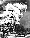
On October 22, 1913, Dawson suffered its first major disaster. Stag Canyon Mine No. 2 was shaken by an explosion that was felt two miles (3.2 km) away in the town proper. Relief teams rushed in from surrounding communities and as far away as Pittsburg, Kansas and Rock Springs, Wyoming, but of the 286 men who arrived to work in the Stag Canyon mine that morning, only 23 survived.[10] Most of 263 killed were Hispanics and foreign-born Italians and Greeks.[11] One of the surviving miners was George Mavroidis who witnessed 16 men around him lose their lives before he himself lost consciousness. He woke up the next morning in the mine office.[12]
Phelps Dodge sent a special train from El Paso, Texas, with doctors and nurses, but to no avail. Of the worker casualties, 146 were Italian and 36 were Greek.[13] Two rescuers died during the rescue effort. It was later determined that the explosion was caused by a dynamite charge set off while the mine was in general operation, igniting coal dust in the mine. This was in violation of mining safety laws. The other mines remained productive after the disaster in Mine No. 2.
In 1923, another mine explosion killed 123 miners:[14] On February 8, Stag Canyon Mine No. 1 suffered an explosion. A mine car derailed, knocking down timbers and the electric trolley cable, causing sparks and igniting coal dust in the mine.[15] many of them descendants of the men who died in 1913.
Shutdown
Dawson did not become a ghost town until 1950, when the Phelps Dodge Corporation shut down the mines. At closure, Mine 6 was the largest producer, and several other mines had been previously closed out because of declining demand. The closures were also due in large part to the completion of the twenty-five year coal contract with the Southern Pacific Railroad. The entire town was sold or razed, with some of the miners' houses moved to other locations.
The Southern Pacific branch to Tucumcari was lifted at about the same time. But in 1965 the northern portion of the roadbed was used by the Santa Fe Railroad, for new tracks continuing up the canyon through Dawson plus an additional 15 miles or 24.1 km (approximately) to a new mine in York Canyon. This open-pit mine was initially operated by Kaiser Steel, with their output being transported to their steel mill at Fontana, California.[5] The York Canyon mine was operated by several different companies, finally closing in the early 2000s. As of 2016, the track remained in place.
Description
The town of Dawson is now largely gone, with only a few buildings remaining.[16] The tall smoke stacks of the coking ovens were eventually demolished in the early 2000s because they represented a liability to the current owner of the property.
The only significant landmark remaining in Dawson is the Dawson Cemetery, which is on the National Register of Historic Places.[17][18] The cemetery is filled with iron crosses painted white, marking the graves of many miners who died in the mines. Other markers show the burial locations of other residents of Dawson.
Dawson can be reached by taking Route 64 approximately 12 miles (19.3 km) east of Cimarron and then heading north onto A38 at the striped sign and proceeding on that road for another 5 miles (8.1 km). After A38 crosses the adjacent railroad tracks a second time, turn onto the dirt road on the right (which proceeds east of A38 for approximately 1,000 feet (304.8 meters)) to reach the site of the Dawson cemetery. The ruins of Dawson can be seen by continuing north on A38, which turns into Barus Road and then splits into Lauretta Road and Rail Canyon Road.
Cimarron is a village in Colfax County, New Mexico, United States, which sits on the eastern slopes of the Sangre de Cristo Mountains. The population was 792 at the 2020 census, making it the fourth most populous municipality in Colfax County.
Phelps Dodge Corporation was an American mining company founded in 1834 as an import-export firm by Anson Greene Phelps and his two sons-in-law William Earle Dodge, Sr. and Daniel James. The latter two ran Phelps, James & Co., the part of the organization based in Liverpool, England. The import-export firm at first exported United States cotton from the Deep South to England and imported various metals to the US needed for industrialization. With the expansion of the Western frontier in North America, the corporation acquired mines and mining companies, including the Copper Queen Mine in Cochise County, Arizona and the Dawson, New Mexico coal mines. It operated its own mines and acquired railroads to carry its products. By the late 19th century, it was known as a mining company.
Ludlow is a ghost town in Las Animas County, Colorado, United States. It was the site of the Ludlow Massacre–part of the Colorado Coalfield War–in 1914. The town site is located at the entrance to a canyon in the foothills of the Sangre de Cristo Mountains. It is located along the western side of Interstate 25 approximately 12 miles (19 km) north of the town of Trinidad. Nearby points of interest include the Ludlow Monument, a monument to the coal miners and their families who were killed in the 1914 massacre, the Hastings coke ovens, and the Victor American Hastings Mine Disaster Monument.
The Colorado Fuel and Iron Company (CF&I) was a large steel conglomerate founded by the merger of previous business interests in 1892. By 1903 it was mainly owned and controlled by John D. Rockefeller and Jay Gould's financial heirs. While it came to control many plants throughout the country, its main plant was a steel mill on the south side of Pueblo, Colorado, and was the city's main industry for most of its history. From 1901 to 1912, Colorado Fuel and Iron was one of the Dow Jones Industrials. The steel-market crash of 1982 led to the decline of the company. After going through several bankruptcies, the company was acquired by Oregon Steel Mills in 1993, and changed its name to Rocky Mountain Steel Mills. In January 2007, Rocky Mountain Steel Mills, along with the rest of Oregon Steel's holdings, were acquired by EVRAZ Group, a Russian steel corporation, for $2.3 billion.
Luxor is an unincorporated community and coal town in Hempfield Township, Westmoreland County, Pennsylvania, United States.
James Walter Douglas was a British North America born mining engineer and businessman who introduced a number of metallurgical innovations in copper mining and amassed a fortune through the copper mining industry of Bisbee, Arizona Territory and Sonora before and after the turn of the 20th century.
The Maxwell Land Grant, also known as the Beaubien-Miranda Land Grant, was a 1,714,765-acre (6,939.41 km2) Mexican land grant in Colfax County, New Mexico, and part of adjoining Las Animas County, Colorado. This 1841 land grant was one of the largest contiguous private landholdings in the history of the United States. The New Mexico communities of Cimarron, Dawson, Elizabethtown, Baldy Town, Maxwell, Miami, Raton, Rayado, Springer, Ute Park and Vermejo Park came to be located within the grant, as well as numerous places that are now ghost towns.
Vermejo Park Ranch, Vermejo Ranch, or Vermejo, is a 550,000-acre (220,000 ha) nature reserve and guest ranch in northeastern New Mexico and southern Colorado. Ted Turner Reserves, the luxury hospitality company founded by Ted Turner, includes conservation research and ecosystem restoration along with guest operations. The reserve, which stretches from the Great Plains at an elevation of 5,867 ft (1,788 m) to the summit of the Sangre de Cristo Mountains, reaches an elevation of 12,931 ft (3,941 m). The ranch produces significant quantities of coalbed methane, a type of natural gas.
Sego is a ghost town in Grand County, Utah, United States. It lies in the narrow, winding Sego Canyon, in the Book Cliffs some 5 miles (8.0 km) north of Thompson Springs. Formerly an important eastern Utah coal mining town, Sego was inhabited about 1910–1955. The town is accessed via the grade of the Ballard & Thompson Railroad, a spur from the Denver and Rio Grande Western built by the founders of the town to transport the coal.
The El Paso and Southwestern Railroad began in 1888 as the Arizona and South Eastern Railroad, a short line serving copper mines in southern Arizona. Over the next few decades, it grew into a 1200-mile system that stretched from Tucumcari, New Mexico, southward to El Paso, Texas, and westward to Tucson, Arizona, with several branch lines, including one to Nacozari, Mexico. The railroad was bought by the Southern Pacific Railroad in 1924 and fully merged into its parent company in 1955. The EP&SW was a major link in the transcontinental route of the Golden State Limited.
The Detroit Copper Mining Company was an American copper mining and smelting operation based in Morenci, Arizona. Incorporated in July 1872, it existed as an independent company until 1897, when a controlling interest in the company was purchased by the predecessor of the Phelps Dodge Corporation. It continued to exist as a subsidiary of Phelps Dodge & Co until 1917, when all Phelps Dodge operations in the area were consolidated into the new Phelps Dodge Corporation, Morenci Branch.
Standardville is a ghost town in Carbon County, Utah, United States. Standardville was established after coal was discovered in the area in 1912. The layout of the town was so well-planned, it became the "standard" for all mining towns to follow, which resulted in the town name of Standardville. In 1922, a group of striking miners killed a mine guard and wounded two miners before escaping. In 1930, 20 miners were killed in a mine explosion caused by carbon monoxide gas. In 1950, the mine shut down and people began to relocate elsewhere. A couple families remained until the 1970s, after which Standardville was abandoned.
Winter Quarters is a ghost town in Carbon County, Utah, United States. Coal was discovered in the area in 1875, and later that year, the Pleasant Valley Coal Company began coal mining operations. A group of coal miners was delayed during an early winter storm in 1877, which led to the town's name of Winter Quarters. On May 1, 1900, an explosion in the Winter Quarters Number Four mine killed 200 miners. Despite the mine explosion, the coal mining operations remained active until 1922, when the opening of a new mine in Castle Gate caused many people to relocate there. By 1930, Winter Quarters was abandoned.
The El Paso and Northeastern Railway (EP&NE) was a short line railroad that was built around the beginning of the twentieth century to help connect the industrial and commercial center at El Paso, Texas, with physical resources and the United States' national transportation hub in Chicago. Founded by Charles Eddy, the EP&NE was the primary railroad in a system organized under the New Mexico Railway and Coal Company (NMRy&CCo), a holding company which owned several other railroads and also owned mining and industrial properties served by the lines.
Cambria (1889–1928) is a ghost town located in the Black Hills of Weston County, Wyoming, United States. It was a successful coal mining town for decades.
The Dawson Stags were a minor league baseball team based in Dawson, New Mexico in 1912. Dawson briefly played in the 1912 season as members of the Class D level Rocky Mountain League. The Dawson team began play when the Colorado Springs Millionaires relocated during the season. Dawson, New Mexico did not host another minor league team and is a ghost town today.
Tercio is a ghost town and former coal mine in Las Animas County, in the U.S. state of Colorado. The GNIS classifies it as a populated place. A post office called Tercio was established in 1902, and remained in operation until 1949. The community was the third coal mining community established by the Colorado Fuel and Iron Company, hence the name.
Dawson Cemetery is a historic cemetery in Dawson, New Mexico. It was established in 1913. It has been listed on the National Register of Historic Places since April 9, 1992.
Berwind is a ghost town in Las Animas County, Colorado, nestled in Berwind Canyon 3.1 miles (5.0 km) southwest of Ludlow and 15 miles (24 km) northwest of Trinidad. The settlement was founded in 1888 as a company town for the Colorado Coal & Iron Company and, from 1892, was operated by the Colorado Fuel & Iron Company. It was a battle site in October 1913 and April 1914 during the Colorado Coalfield War, housing a Colorado National Guard encampment during the latter stages of the conflict.
Sherman, James E. and Sherman, Barbara H. (1980) "Dawson" Ghost Towns and Mining Camps of New Mexico (2nd edition) University of Oklahoma Press, Norman, Oklahoma, pp.62–69, ISBN0-8061-1106-2
Wilson, Delphine Dawson (1997) John Barkley Dawson: Pioneer, Cattleman, Rancher (2nd edition) Wilson, no location specified, OCLC43944875
This page is based on this Wikipedia article Text is available under the CC BY-SA 4.0 license; additional terms may apply. Images, videos and audio are available under their respective licenses.