
Vizianagaram district is one of the six districts in the Uttarandhra region of the Indian state of Andhra Pradesh with its headquarters located at Vizianagaram. The district was once the part of ancient Kalinga.Saripilli Dibbilingeswara temple, Jayathi Mallikarjuna Temple are the finest examples of ancient Eastern Ganga Dynasty built monuments in the district. The district is bounded on the east by the district of Srikakulam, north by Parvathipuram Manyam south by Visakhapatnam, Anakapalli, southeast by the Bay of Bengal, and west by Alluri Sitharama Raju district. It was formed on 1 June 1979, with some parts carved from the neighbouring districts of Srikakulam and Visakhapatnam. The district is named after the princely state of Vizianagaram. In 2011, it was the least populous district in Andhra Pradesh.

Karimnagar district is one of the 33 districts of the Indian state of Telangana. Karimnagar city is its administrative headquarters. The district shares boundaries with Peddapalli, Jagityal, Sircilla, Siddipet, Jangaon, Hanamkonda district and Jayashankar Bhupalapally districts.

Srikakulam district is one of the twenty-six districts of the Indian state of Andhra Pradesh, located in the Uttarandhra region of the state, with its headquarters located at Srikakulam. It is one of the six districts, located in the extreme northeastern direction of the state. It was formerly known as Chicacole, and was under Ganjam district till 1936 April 1, then merged under Vizagapatam district. Srikakulam district forms the core area of Kalinga where most of its historical capitals like Kalinganagari, pithunda, Dantapuram are located.

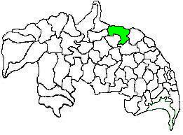
Mangalagiri mandal is one of the 18 mandals in Guntur district of the Indian state of Andhra Pradesh. It is under the administration of Tenali revenue division and the headquarters are located at Mangalagiri town part of Mangalagiri Tadepalli Municipal Corporation. The mandal is bounded by Thullur, Tadepalle, Tadikonda, Pedakakani and Duggirala mandals and a portion of the mandal lies on the banks of Krishna River.
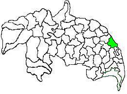
Tenali mandal is one of the 18 mandals in Guntur district of the Indian state of Andhra Pradesh. It is under the administration of Tenali revenue division, headquartered at Tenali. The mandal is located in Velanadu region, bounded by Pedakakani, Duggirala, Kollipara, Vemuru, Amruthalur, Tsundur and Chebrole mandals.
Repalle mandal is one of the 25 mandals in Bapatla district of the state of Andhra Pradesh, India. It is under the administration of Bapatla revenue division and the mandal headquarters are located at Repalle. The mandal is situated on the banks of Krishna River of Velanadu region and is bounded by Bhattiprolu, Nagaram and Nizampatnam mandals.
Guntur Urban mandal was a former mandal in Guntur district of the Indian state of Andhra Pradesh, before it was split into Guntur East and Guntur West mandals in 2018. It was under the administration of Guntur revenue division and its headquarters at Guntur, The mandal was bounded by Medikonduru, Tadikonda, Pedakakani, Edlapadu, Prathipadu, Vatticherukuru and Chebrole mandals.

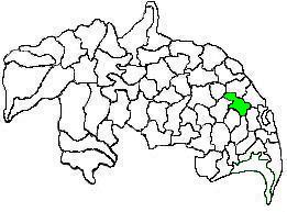
Duggirala mandal is one of the 18 mandals in Guntur district of the Indian state of Andhra Pradesh. It is under the administration of Tenali revenue division and the headquarters are located at Duggirala. The mandal is bounded by Mangalagiri, Pedakakani, Tenali and Kollipara mandals. Krishna River lies to the northeast of the Duggirala mandal.
Kollur mandal is one of the 25 mandals in Bapatla district of the Indian state of Andhra Pradesh. It is under the administration of Repalle revenue division and the headquarters are located at Kollur.

Nizampatnam mandal is one of the 25 mandals in Bapatla district of the state of Andhra Pradesh, India. It is under the administration of Repalle Revenue Division and the headquarters are located at Nizampatnam. The mandal is bounded by Repalle, Nagaram, Pittalavanipalem and Karlapalem mandals. The mandals lies on the shore of Bay of Bengal and a portion of the mandal lies on the banks of Krishna River.
Bapatla mandal is one of the 25 mandals in Bapatla district of the state of Andhra Pradesh, India. It is under the administration of Bapatla revenue division and the headquarters are located at Bapatla. The mandal is bounded by Kakumanu, Ponnur, Karlapalem mandals of Guntur district. It also shares borders with Prakasam district and a portion of it lies on the coast of Bay of Bengal.
Amaravathi mandal is one of the 28 mandals in Palnadu district of the Indian state of Andhra Pradesh. It is under the administration of Sattenapalli revenue division and the headquarters are located at Amaravathi. The mandal is located on the banks of Krishna River, at a distance 27 km from the district headquarters. It is bounded by Atchampet, Krosuru, Pedakurapadu, Tadikonda and Thullur mandals.
Kollipara mandal is one of the 18 mandals in Guntur district of the state of Andhra Pradesh, India. It is under the administration of Tenali revenue division and the headquarters are located at Kollipara. The mandal is situated on the banks of the Krishna River, bordered by Duggirala, Tenali, Vemuru and Kollur mandal.

Thullur mandal is one of the 18 mandals in Guntur district of the Indian state of Andhra Pradesh. It is under the administration of Guntur Revenue Division and the headquarters are located at Thullur. The mandal is situated on the banks of Krishna River, bounded by Amaravathi, Tadikonda, Tadepalle and Mangalagiri mandals. The mandal is also a part of the new capital city of Andhra Pradesh to be developed. 18 villages from the mandal fall under the jurisdiction of Andhra Pradesh Capital City.

Atchampet mandal is one of the 28 mandals in Palnadu district of the Indian state of Andhra Pradesh. The mandal is under the administration of Sattenapalli revenue division and the headquarters are located at Chamarru. The mandal is located on the banks of Krishna River, at a distance 68 km from the district headquarters. It is bounded by Amaravathi, Krosuru, Pedakurapadu, Bellamkonda and Sattenapalli mandals.
Nidamarru Mandal is one of 28 Mandals in the Eluru district of Andhra Pradesh, India. Its headquarters is located in Nidamarru. Its bordering states are Unguturu mandal, Bhimadole mandal, Pentapadu mandal, Ganapavaram mandal, Akividu mandal and Undi mandal.
Unguturu mandal is one of 28 mandals in the Eluru district of the Indian state of Andhra Pradesh. The headquarters are located at Unguturu. The mandal is bordered by Tadepalligudem mandal and Pentapadu mandal to the north, Nallajerla mandal to the west, Nidamarru mandal to the east, and by Dwaraka Tirumala mandal and Bhimadole mandal to the south

Kalidindi mandal is one of the 28 mandals in Eluru district of the Indian state of Andhra Pradesh. The headquarters of this mandal is located at Kalidindi town. The mandal is bordered by Kalidindi mandal to the north, West Godavari district to the east, Kruthivennu mandal to the south, and Bantumilli mandal to the west.
Challapalli mandal is one of the 25 mandals in the Krishna district of the Indian state of Andhra Pradesh. The headquarters of this mandal are located in Challapalli.
Allavaram mandal is one of the 22 mandals in Dr. B.R. Ambedkar Konaseema district of Andhra Pradesh. As per census 2011, there are 14 villages in this mandal.


