Related Research Articles

Bodmin is a civil parish and historic town in Cornwall, England, United Kingdom. It is situated south-west of Bodmin Moor.

North Cornwall is an area of Cornwall, England, United Kingdom. It is also the name of a former local government district, which was administered from Bodmin and Wadebridge 50.516°N 4.835°W. Other towns in the area are Launceston, Bude, Padstow, and Camelford.

The Bodmin & Wenford Railway (BWR) is a heritage railway, based at Bodmin in Cornwall, England. It has an interchange with the national rail network at Bodmin Parkway railway station, the southern terminus of the line.

St Columb Major is a town and civil parish in Cornwall, England, United Kingdom. Often referred to locally as St Columb, it is approximately seven miles (11 km) southwest of Wadebridge and six miles (10 km) east of Newquay The designation Major distinguishes it from the nearby settlement and parish of St Columb Minor on the coast. An electoral ward simply named St Columb exists with a population at the 2011 census of 5,050. The town is named after the 6th-century AD Saint Columba of Cornwall, also known as Columb.

The Saints' Way is an ancient trackway and long-distance footpath in mid Cornwall, England, UK.

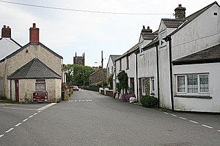
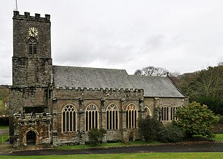
St Wenn is a civil parish and village in Cornwall, England, United Kingdom. The village is situated six miles (10 km) west of Bodmin and nine miles (14.5 km) east of Newquay. The parish population at the 2011 census was 369.
St Clether is a civil parish and village in Cornwall, England, United Kingdom. The village is situated on the east flank of Bodmin Moor approximately eight miles (13 km) west of Launceston in the valley of the River Inny. The population of the civil parish at the 2011 census was 156.

St Goran is a coastal civil parish in Cornwall, England, UK, six miles (10 km) south-southwest of St Austell. The largest settlement in the parish is the coastal village of Gorran Haven, a mile to the east with a further cluster of homes at Trevarrick. The population at the 2011 census was 1,411.
St Newlyn East is a civil parish and village in Cornwall, England, United Kingdom. The village is approximately three miles (5 km) south of Newquay. The name St Newlyn East is locally abbreviated to Newlyn East and according to an anonymous historian writing in The Cornishman in 1880 it was only in recent years that Saint had been added to the parish name.
St Dominic's Holy Well is a natural spring located in the parish of St George, Truro, Cornwall.

St Breward is a civil parish and village in Cornwall, England, United Kingdom. It is on the western side of Bodmin Moor, about 6 miles (10 km) north of Bodmin. At the 2011 census the parish population including Cooksland and Fentonadle was 919.

St Cleer is a civil parish and village in east Cornwall, England, United Kingdom. The village is situated on the southeast flank of Bodmin Moor approximately two miles (3 km) north of Liskeard. The population of the parish in 2001 numbered 3257. This included Barcelona and Common Moor and had increased to 3,297 at the 2011 census. An electoral ward also exists. The population at the 2011 census is 4,366.
The Cornish Way is a cycle route which is part of the National Cycle Network that links Bude to Land's End. The route is via Padstow or St Austell and is 180 miles in length.

Warleggan or Warleggon is a civil parish on the southern edge of Bodmin Moor in Cornwall, England, United Kingdom.

The River Allen in north Cornwall is one of two rivers in Cornwall which share this name. In this case the name is the result of a mistake made in 1888 by Ordnance Survey, replacing the name Layne with Allen which is the old name for the lower reaches of the Camel. The other River Allen runs through Truro.
Christianity in Cornwall began in the 4th or 5th century AD when Western Christianity was introduced into Cornwall along with the rest of Roman Britain. Over time it became the official religion, superseding previous Celtic and Roman practices. Early Christianity in Cornwall was spread largely by the saints, including Saint Piran, the patron of the county. Cornwall, like other parts of Britain, is sometimes associated with the distinct collection of practices known as Celtic Christianity but was always in communion with the wider Catholic Church. The Cornish saints are commemorated in legends, churches and placenames.

The River Seaton is a river in east Cornwall, England, UK which flows southwards for 11 miles (17 km) into the English Channel.

The River Lerryn is a river in east Cornwall, England, UK, a tributary of the River Fowey. The Lerryn is the largest of the tributaries which enter the estuary of the Fowey. The river is tidal up to the village of Lerryn. The landscape of the Lerryn catchment is rural and includes heathland, moorland and rough pasture in the upper reaches and broadleaf, coniferous and mixed plantation woodland in the lower. This catchment includes four SSSIs, including Redlake Meadows & Hoggs Moor. The Lerryn rises at Fairy Cross on the southern slopes of Bodmin Moor and flows south-southwest until it enters the Fowey estuary.

Shire Hall is a former judicial facility at Mount Folly Square in Bodmin, Cornwall. It was the main courthouse in Cornwall from 1838 to 1988. It is a Grade II* listed building.
References
- ↑ Cornish Church Guide (1925) Truro: Blackford; pp. 60-61
Coordinates: 50°28′47″N4°43′11″W / 50.479742°N 4.719631°W
| | This article about a building or structure in Cornwall is a stub. You can help Wikipedia by expanding it. |
| | This article about a British Christian monastery, abbey, priory or other religious house is a stub. You can help Wikipedia by expanding it. |