
Moczydła is a village in the administrative district of Gmina Jakubów, within Mińsk County, Masovian Voivodeship, in east-central Poland. It lies approximately 4 kilometres (2 mi) north-east of Jakubów, 12 km (7 mi) north-east of Mińsk Mazowiecki, and 49 km (30 mi) east of Warsaw.
Bugaj is a village in the administrative district of Gmina Babiak, within Koło County, Greater Poland Voivodeship, in west-central Poland. It lies approximately 4 kilometres (2 mi) east of Babiak, 16 km (10 mi) north of Koło, and 123 km (76 mi) east of the regional capital Poznań.
Kiejsze is a village in the administrative district of Gmina Babiak, within Koło County, Greater Poland Voivodeship, in west-central Poland. It lies approximately 6 kilometres (4 mi) south-east of Babiak, 13 km (8 mi) north-east of Koło, and 123 km (76 mi) east of the regional capital Poznań.
Grodna is a village in the administrative district of Gmina Grzegorzew, within Koło County, Greater Poland Voivodeship, in west-central Poland. It lies approximately 10 kilometres (6 mi) north-east of Grzegorzew, 13 km (8 mi) east of Koło, and 131 km (81 mi) east of the regional capital Poznań.
Lutomirów is a village in the administrative district of Gmina Dąbie, within Koło County, Greater Poland Voivodeship, in west-central Poland. It lies approximately 8 kilometres (5 mi) west of Dąbie, 13 km (8 mi) south-east of Koło, and 128 km (80 mi) east of the regional capital Poznań.
Rzuchów is a village in the administrative district of Gmina Dąbie, within Koło County, Greater Poland Voivodeship, in west-central Poland. It lies approximately 9 kilometres (6 mi) north-west of Dąbie, 11 km (7 mi) south-east of Koło, and 127 km (79 mi) east of the regional capital Poznań.
Barłogi is a village in the administrative district of Gmina Grzegorzew, within Koło County, Greater Poland Voivodeship, in west-central Poland. It lies approximately 8 kilometres (5 mi) north-east of Grzegorzew, 10 km (6 mi) east of Koło, and 128 km (80 mi) east of the regional capital Poznań.
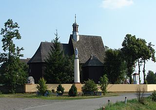
Borysławice Kościelne is a village in the administrative district of Gmina Grzegorzew, within Koło County, Greater Poland Voivodeship, in west-central Poland. It lies approximately 11 kilometres (7 mi) north-east of Grzegorzew, 14 km (9 mi) east of Koło, and 131 km (81 mi) east of the regional capital Poznań.
Borysławice Zamkowe is a village in the administrative district of Gmina Grzegorzew, within Koło County, Greater Poland Voivodeship, in west-central Poland. It lies approximately 11 kilometres (7 mi) north-east of Grzegorzew, 12 km (7 mi) east of Koło, and 130 km (81 mi) east of the regional capital Poznań.

Bylice is a village in the administrative district of Gmina Grzegorzew, within Koło County, Greater Poland Voivodeship, in west-central Poland. It lies approximately 13 kilometres (8 mi) north-east of Grzegorzew, 13 km (8 mi) north-east of Koło, and 128 km (80 mi) east of the regional capital Poznań.
Bylice-Kolonia is a village in the administrative district of Gmina Grzegorzew, within Koło County, Greater Poland Voivodeship, in west-central Poland. It lies approximately 13 kilometres (8 mi) north-east of Grzegorzew, 13 km (8 mi) north-east of Koło, and 128 km (80 mi) east of the regional capital Poznań.

Grzegorzew is a village in Koło County, Greater Poland Voivodeship, in west-central Poland. It is the seat of the gmina called Gmina Grzegorzew. It lies approximately 6 kilometres (4 mi) south-east of Koło and 125 km (78 mi) east of the regional capital Poznań.
Kiełczewek is a village in the administrative district of Gmina Grzegorzew, within Koło County, Greater Poland Voivodeship, in west-central Poland. It lies approximately 8 kilometres (5 mi) north of Grzegorzew, 8 km (5 mi) north-east of Koło, and 125 km (78 mi) east of the regional capital Poznań.
Ladorudzek is a village in the administrative district of Gmina Grzegorzew, within Koło County, Greater Poland Voivodeship, in west-central Poland. It lies approximately 5 kilometres (3 mi) east of Grzegorzew, 11 km (7 mi) south-east of Koło, and 130 km (81 mi) east of the regional capital Poznań.
Ponętów Dolny is a village in the administrative district of Gmina Grzegorzew, within Koło County, Greater Poland Voivodeship, in west-central Poland. It lies approximately 6 kilometres (4 mi) north-east of Grzegorzew, 10 km (6 mi) east of Koło, and 128 km (80 mi) east of the regional capital Poznań.
Zabłocie is a village in the administrative district of Gmina Grzegorzew, within Koło County, Greater Poland Voivodeship, in west-central Poland. It lies approximately 11 kilometres (7 mi) north-east of Grzegorzew, 12 km (7 mi) north-east of Koło, and 129 km (80 mi) east of the regional capital Poznań.
Górki is a village in the administrative district of Gmina Kłodawa, within Koło County, Greater Poland Voivodeship, in west-central Poland. It lies approximately 3 kilometres (2 mi) south-west of Kłodawa, 18 km (11 mi) east of Koło, and 136 km (85 mi) east of the regional capital Poznań.
Kiełczew Smużny Czwarty is a village in the administrative district of Gmina Koło, within Koło County, Greater Poland Voivodeship, in west-central Poland. It lies approximately 10 kilometres (6 mi) north-east of Koło and 124 km (77 mi) east of the regional capital Poznań.
Lucjanowo is a village in the administrative district of Gmina Koło, within Koło County, Greater Poland Voivodeship, in west-central Poland. It lies approximately 5 kilometres (3 mi) north-east of Koło and 121 km (75 mi) east of the regional capital Poznań.
Młynek is a village in the administrative district of Gmina Osiek Mały, within Koło County, Greater Poland Voivodeship, in west-central Poland. It lies approximately 6 kilometres (4 mi) south of Osiek Mały, 6 km (4 mi) north-west of Koło, and 115 km (71 mi) east of the regional capital Poznań.


