
Schuylkill County is a county in the Commonwealth of Pennsylvania. As of the 2010 census, the population was 148,289. The county seat is Pottsville. The county was created on March 1, 1811, from parts of Berks and Northampton counties and named for the Schuylkill River, which originates in the county. On March 3, 1818 additional territory in its northeast was added from Columbia and Luzerne Counties.

Bernville is a borough in Berks County, Pennsylvania, United States. The population was 955 at the 2010 census. Bernville is bordered by Penn Township to the north, east, and south and by Jefferson Township to the west.

Conshohocken is a borough on the Schuylkill River in Montgomery County, Pennsylvania, in suburban Philadelphia. Historically a large mill town and industrial and manufacturing center, after the decline of industry in recent years Conshohocken has developed into a center of riverfront commercial and residential development. In the regional slang, it is sometimes referred to by the colloquial nickname Conshy. The name "Conshohocken" comes from the Unami language, from either Kanshi'hak'ing, meaning "Elegant-ground- place", or, more likely, Chottschinschu'hak'ing, which means "Big-trough-ground-place" or "Large-bowl-ground-place", referring to the big bend in the Tulpe'hanna.

Auburn is a borough in Schuylkill County, Pennsylvania, United States. The population was 741 at the 2010 census.

Girardville is a borough in Schuylkill County, Pennsylvania, 58 miles (93 km) northwest of Reading. Anthracite coal deposits are in the region. Coal-mining provided employment and incomes for many of the 3,666 people who lived there in 1900. In 1910, 4,396 individuals called it home. The population was 1,519 at the 2010 census. It was founded in 1832 and is named after Stephen Girard of Philadelphia who purchased large land holdings in and around the town. It was incorporated as a borough in 1872. It is known to many in Schuylkill County as "Gun-Town", for reasons unknown.

Orwigsburg is a borough in Schuylkill County, Pennsylvania, United States. Named for its founder, Peter Orwig, from West Brunswick Township in 1823. The population was 3,099 at the 2010 census. Orwigsburg was the original county seat until the seat was moved to Pottsville in 1851.

Pottsville is a city in, and the county seat of, Schuylkill County, Pennsylvania, United States. The population was 14,324 at the 2010 census, and is the principal city of the Pottsville, PA Micropolitan Statistical Area. The city lies along the west bank of the Schuylkill River, 52 miles (84 km) south of Wilkes-Barre. It is located in Pennsylvania's Coal Region.

Schuylkill Haven is a borough in Schuylkill County, Pennsylvania, four miles (6 km) south of Pottsville and 89 miles (143 km) north-west of Philadelphia, in the United States. The borough's population was 5,437 as of the 2010 census. Schuylkill Haven is situated along the Schuylkill River for which it is named. Schuylkill Haven is a focal point of activity in southern Schuylkill County.

Tower City is a borough in Schuylkill County, Pennsylvania, United States. The population was 1,346 at the 2010 census.
Swatara Creek is a 72-mile-long (116 km) tributary of the Susquehanna River in east central Pennsylvania in the United States. It rises in the Appalachian Mountains in central Schuylkill County and passes through northwest Lebanon Valley before draining into the Susquehanna at Middletown.

Tulpehocken Creek is a 39.5-mile-long (63.6 km) tributary of the Schuylkill River in southeastern Pennsylvania in the United States, and during the American Canal Age, once provided nearly half the length of the Union Canal linking the port of Philadelphia, the largest American city and the other communities of Delaware Valley with the Susquehanna basin and the Pennsylvania Canal System connecting the Eastern seaboard to Lake Erie and the new settlements of the Northwest Territory via the Allegheny}, Monongahela. and Ohio Rivers at Pittsburgh.
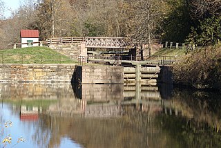
The Schuylkill Canal, or Schuylkill Navigation, was a system of interconnected canals and slack-water pools along the Schuylkill River in the U.S. state of Pennsylvania, built as a commercial waterway in the early 19th-century. Chartered in 1815, the navigation opened in 1825 to provide transportation and water power. At the time, the river was the least expensive and most efficient method of transporting bulk cargo, and the eastern seaboard cities of the U.S. were experiencing an energy crisis due to deforestation. It fostered the mining of anthracite coal as the major source of industry between Pottsville and eastern markets. Along the tow-paths, mules pulled barges of coal from Port Carbon through the water gaps to Pottsville; locally to the port and markets of Philadelphia; and some then by ship or through additional New Jersey waterways, to New York City markets.
Union Water Works, commonly known as Water Works, is an unincorporated community in North Annville Township, Lebanon County, Pennsylvania, United States.
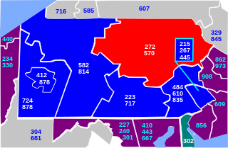
Area codes 570 and 272 are telephone area codes serving the northeast quadrant of Pennsylvania, including the cities/towns of Scranton, Wilkes-Barre, Williamsport, Stroudsburg, East Stroudsburg, Pittston, Carbondale, Hazleton, Clarks Summit, Towanda, Bloomsburg, Sayre, Tunkhannock, Berwick, Milford, Montrose, Honesdale, Pocono Pines, Nanticoke, Tamaqua, Shavertown, Dallas, Mahanoy City, Sunbury, Jim Thorpe, as far south as Pottsville and as far west as Lock Haven. 570 is the main area code, while 272 is an overlay covering the same territory as 570.
Perkiomen Creek is a 37.7-mile-long (60.7 km) tributary of the Schuylkill River in Berks, Lehigh and Montgomery counties, Pennsylvania in the United States. The water course was also named Perquaminck Creek, on Thomas Holme's 1687 map.
Mahantango Creek is a 36.2-mile-long (58.3 km) tributary of the Susquehanna River in Dauphin, Northumberland, Schuylkill, and Snyder County counties, Pennsylvania in the United States.

Maiden Creek is a 20.3-mile-long (32.7 km) tributary of the Schuylkill River in Berks County, Pennsylvania in the United States. The name "Maiden" is an English translation of the Native American word Ontelaunee.

Jalappa is a village in Tilden Township, Berks County, Pennsylvania. It is located on Old Route 22 less than a mile south of Interstate 78. Access to 78 is from Hamburg and Shartlesville. The Mill Creek flows eastward through the village to the Schuylkill River. The village uses the Hamburg ZIP code of 19526.

Mill Creek is a 6.6-mile-long (10.6 km) tributary of the Schuylkill River in Lower Merion Township, Montgomery County, Pennsylvania, United States.

Drehersville is an unincorporated community on the Little Schuylkill River and the NW foot of Blue Mountain in East Brunswick Township and West Brunswick Township, Schuylkill County in Pennsylvania. Route 895 passes through Drehersville, which serves as a western gateway for Hawk Mountain Sanctuary. It is pronounced "DRAY-herz-vil" or occasionally "DRAIRZ-vil." Drehersville is split between the New Ringgold and Orwigsburg post offices with the ZIP codes of 17960 and 17961, respectively. It is served by the Blue Mountain School District.
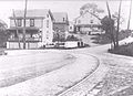 Mill Site -Early 1900s Trolley Tracks