
Bosnia and Herzegovina, abbreviated BiH or B&H, sometimes called Bosnia–Herzegovina and often known informally as Bosnia, is a country at the crossroads of south and southeast Europe, located in the Balkans. The capital and largest city is Sarajevo. Bosnia and Herzegovina borders Serbia to the east, Montenegro to the southeast, and Croatia to the north and southwest. It is not entirely landlocked; in the south it has a narrow coast on the Adriatic Sea within the Mediterranean, which is about 20 kilometres long and surrounds the town of Neum. Bosnia, which is the inland region of the country, has a moderate continental climate with hot summers and cold, snowy winters. In the central and eastern regions of the country, the geography is mountainous, in the northwest it is moderately hilly, and in the northeast it is predominantly flat. Herzegovina, which is the smaller, southern region of the country, has a Mediterranean climate and is mostly mountainous.
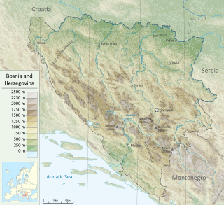
Bosnia and Herzegovina is located in Southeastern Europe, in the western Balkans. It has a 932 km (579 mi) border with Croatia to the north and southwest, a 357 km (222 mi) border with Serbia to the east, and a 249 km (155 mi) border with Montenegro to the southeast. It borders the Adriatic Sea along its 20 km (12 mi) coastline.

Sarajevo is the capital and largest city of Bosnia and Herzegovina, with a population of 275,569 in its administrative limits. The Sarajevo metropolitan area including Sarajevo Canton, East Sarajevo and nearby municipalities is home to 555,210 inhabitants. Located within the greater Sarajevo valley of Bosnia, it is surrounded by the Dinaric Alps and situated along the Miljacka River in the heart of the Balkans, a region of Southern Europe.

The General Framework Agreement for Peace in Bosnia and Herzegovina, also known as the Dayton Agreement or the Dayton Accords, is the peace agreement reached at Wright-Patterson Air Force Base near Dayton, Ohio, United States, on 21 November 1995, and formally signed in Paris, on 14 December 1995. These accords put an end to the three-and-a-half-year-long Bosnian War, one of the Yugoslav Wars.

The Dinaric Alps, also commonly Dinarides, are a mountain range in Southern and Southeastern Europe, separating the continental Balkan Peninsula from the Adriatic Sea. They stretch from Italy in the northwest through Slovenia, Croatia, Bosnia and Herzegovina, Serbia, Montenegro, and Kosovo to Albania in the southeast.

Republika Srpska is one of the two entities of Bosnia and Herzegovina, the other being the Federation of Bosnia and Herzegovina. It is located in the north and east of the country. Its largest city and administrative centre is Banja Luka, lying on the Vrbas river.

Jajce is a town and municipality located in the Central Bosnia Canton of the Federation of Bosnia and Herzegovina, an entity of Bosnia and Herzegovina. According to the 2013 census, the town has a population of 7,172 inhabitants, with 27,258 inhabitants in the municipality. It is situated in the region of Bosanska Krajina, on the crossroads between Banja Luka, Mrkonjić Grad and Donji Vakuf, on the confluence of the rivers Pliva and Vrbas.
The Sarajevo Canton, officially the Canton of Sarajevo is one of 10 cantons of the Federation of Bosnia and Herzegovina in Bosnia and Herzegovina. Its cantonal seat is the city of Sarajevo, also the capital city of Bosnia and Herzegovina.
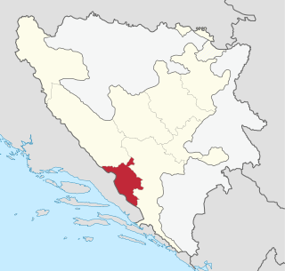
The West Herzegovina Canton is one of the cantons of the Federation of Bosnia and Herzegovina. The West Herzegovina Canton is in the Herzegovina region in the southwest of Bosnia and Herzegovina. Its seat of government is in Široki Brijeg, while other municipalities within the Canton are Grude, Ljubuški and Posušje. It has 94,898 inhabitants, of whom more than 98% are ethnic Croats.

The Sutjeska National Park is a national park located in Bosnia and Herzegovina. Established in 1962, it is Bosnia and Herzegovina's oldest national park. It includes the highest peak of Maglić at over 2,386 metres (7,828 ft), on the border with Montenegro. The Montenegrin part of Maglić massif in the park has also formed the Trnovačko Jezero. The Strict Nature Reserve "Perućica", one of the last two remaining primeval forests in Europe, is part of the park. The park is also famous as being the location of the Battle of the Sutjeska in 1943 during World War II. It is an affiliated member of EUROPARC Federation.

Bosnia is the northern region of Bosnia and Herzegovina, encompassing roughly 81% of the country; the other region, the southern part, is Herzegovina.

Banovići is a town and municipality located in Tuzla Canton of the Federation of Bosnia and Herzegovina, an entity of Bosnia and Herzegovina. It is located in northeastern Bosnia and Herzegovina. The intensive development of Banovići began with the construction of the railway Brčko-Banovići in the year 1946. Due to its quality, brown coal from Banovići is well-known all over Europe.

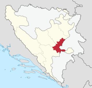
Istočno Sarajevo is de jure capital city of Republika Srpska entity of Bosnia and Herzegovina. It consists of a few suburban areas of pre-war Sarajevo which are now included in the Republika Srpska entity, and newly built areas. With an area of 1450 km2, Istočno Sarajevo is one of the largest administrative areas in the Balkans. As of 2013, it has a population of 61,516 inhabitants. Istočno Sarajevo is the largest city in Republika Srpska in terms of area, while it is in fifth place in terms of population. It is the only city of the entity that includes several municipalities: Istočna Ilidža, Istočno Novo Sarajevo, Pale, Istočni Stari Grad, Sokolac and Trnovo. It is separated from Sarajevo and Canton Sarajevo by the Inter-Entity Boundary Line (IEBL). The City Administration of East Sarajevo is located in the municipality of Istočno Novo Sarajevo, in Stefana Nemanje Street.

The Army of the Republic of Bosnia and Herzegovina, often referred to as Bosnian Army, was the military force of the Republic of Bosnia and Herzegovina. It was established by the government of Bosnia and Herzegovina in 1992 following the outbreak of the Bosnian War. Following the end of the war, and the signing of the Dayton Peace Agreement in 1995, it was transformed into the Army of the Federation of Bosnia and Herzegovina. The ARBiH was the only military force on the territory of Bosnia and Herzegovina recognised as legal by other governments. Under the State Defense Reform Law the Armed Forces of Bosnia and Herzegovina were unified into a single structure, the Armed Forces of Bosnia and Herzegovina (OSBiH), making entity armies defunct.

The First Corps was one of seven units of the Army of the Republic of Bosnia and Herzegovina established in 1992, in the early part of the Bosnian War.

The Drina is a 346 km (215 mi) long Balkans river, which forms a large portion of the border between Bosnia and Herzegovina and Serbia. It is the longest tributary of the Sava River and the longest karst river in the Dinaric Alps which belongs to the Danube river watershed. Its name is derived from the Roman name of the river which in turn is derived from Greek.

The 6th Corps was a corps of the Army of the Republic of Bosnia and Herzegovina.

Herzegovina is the southern and smaller of two main geographical regions of Bosnia and Herzegovina, the other being Bosnia. It has never had strictly defined geographical or cultural-historical borders, nor has it ever been defined as an administrative whole in the geopolitical and economic subdivision of Bosnia and Herzegovina.
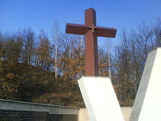
The Križančevo selo massacre occurred in Križančevo selo, a hamlet in the Lašva Valley in central Bosnia, where at least 14 Croat POWs and civilians were killed during an attack by the Army of the Republic of Bosnia and Herzegovina (ARBiH) on Croatian Defence Council (HVO) positions on 22 December 1993.
