
Bollington is a town and civil parish in Cheshire, England, to the east of Prestbury. In the Middle Ages, it was part of the Earl of Chester's manor of Macclesfield and the ancient parish of Prestbury. In 2011, it had a population of 8,310.

Macclesfield was, from 1974 to 2009, a local government district with borough status in Cheshire, England. It included the towns of Bollington, Knutsford, Macclesfield and Wilmslow and within its wider area the villages and hamlets of Adlington, Disley, Gawsworth, Kerridge, Pott Shrigley, Poynton, Prestbury, Rainow, Styal, Sutton and Tytherington.

Kerridge is a village in Cheshire, England, part of the parish of Bollington. Kerridge borders the neighbouring parish of Rainow.

A civil parish is a country subdivision, forming the lowest unit of local government in England. There are 333 civil parishes in the ceremonial county of Cheshire, most of the county being parished. Cheshire East unitary authority is entirely parished. At the 2001 census, there were 565,259 people living in 332 parishes, accounting for 57.5 per cent of the county's population.

Macclesfield is a constituency currently represented in the House of Commons of the UK Parliament since 2010 by David Rutley, a Conservative.
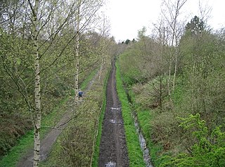
The Middlewood Way is an 11-mile (16 km) "linear park" in England, between Macclesfield and Rose Hill, Marple, opened on 30 May 1985 by Dr David Bellamy.

The River Dean rises at Longclough in Macclesfield Forest on the western edge of the Peak District foothills above the village of Rainow in north east Cheshire, England.
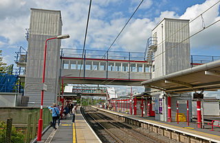
Macclesfield railway station is a main line station serving the Cheshire town of Macclesfield. It lies on the Stafford to Manchester branch of the West Coast Main Line in the United Kingdom.
Bucklow Rural District was, from 1894 to 1974, a local government district in the north of the administrative county of Cheshire, England. Following the Local Government Act 1972, this rural district was split between the new Greater Manchester boroughs of Trafford and Manchester, and Macclesfield, which was retained in Cheshire.
Astbury was one of the eight ancient parishes of the Macclesfield Hundred of Cheshire, England. It included two chapelries and ten townships. The chapelry of Congleton was an ancient borough and became a municipal borough in 1835. Under the Poor Law Amendment Act 1886 the townships and chapelries became civil parishes in their own right. Nine of the townships became part of Congleton Rural District in 1894. whereas Eaton became part of Macclesfield Rural District. At the same time, the Chapelry of Buglawton was made an Urban Sanitary District before being abolished in 1936. On its abolition 2,865 acres (11.59 km2) were transferred to Congleton, 32 acres (130,000 m2) to Eaton and 14 acres (57,000 m2) to North Rode.
Macclesfield Rural District was a rural district of Cheshire, England from 1894 to 1974.

Knutsford was a county constituency in Cheshire which returned one Member of Parliament (MP) to the House of Commons of the Parliament of the United Kingdom from 1885 until it was abolished for the 1983 general election.

The Cheshire Ring is a canal cruising circuit or canal ring, which includes sections of six canals in and around Cheshire and Greater Manchester in North West England: the Ashton Canal, Peak Forest Canal, Macclesfield Canal, Trent and Mersey Canal, Bridgewater Canal and Rochdale Canal.
Alderley was one of the eight ancient parishes of the Macclesfield Hundred of Cheshire, England. It included the following townships:

The Holly Bush is a public house at 75 Palmerston Street, Bollington, Macclesfield, Cheshire, England. It is recorded in the National Heritage List for England as a designated Grade II listed building.

Alderley Edge is a former Urban District in Cheshire, based in the village of Alderley Edge. It was created in 1894 and abolished in 1974 when it was incorporated into the Borough of Macclesfield, which was itself abolished in 2009.

Wilmslow Urban District is a former urban district in Cheshire, based in the town of Wilmslow. It was created in 1894 and abolished in 1974 when it was incorporated into the Borough of Macclesfield, which was itself abolished in 2009.

The North Cheshire Way is a 71-mile (114 km) long-distance footpath in Cheshire, England. It runs approximately eastwards from Hooton railway station on the Wirral peninsula to Disley railway station on the edge of the Peak District, where it connects with the Gritstone Trail. There is a 6-mile (9.7 km) spur from Chester to Croughton.
