
Kericho County is one of the 47 counties in Kenya. The county seats between longitude 35°02' and 35°40' East and between the equator and latitude 0°23' South with an altitude of about 2002m above sea level. It borders Uasin Gishu County to the North West, Baringo County to the North-East, Nandi County to the North-West, Nakuru County to the East and Bomet County to the South, Kisumu County to the Northwest and Nyamira County to the West. It has a population of 901,777 and an area of 2,111 km². Its capital and largest town is Kericho.

Kiambu County is a county in the former Central Province of Kenya. Its capital is Kiambu and its largest town is Thika town. Kiambu County is the second most populous county in Kenya after Nairobi County. Kiambu County borders Nairobi and Kajiado Counties to the South, Machakos to the East, Murang'a to the North and North East, Nyandarua to the North West, and Nakuru to the West. It has a population of 2,417,735.
Isiolo County is a county in the former Eastern Province of Kenya. Its population is 268,002 and its capital and largest city is Isiolo. Isiolo County is to be the first county to be developed as part of the Kenya Vision 2030 program. Other upcoming urban centres are: Garbatulla, Modogashe, Kinna, Merti and Oldonyiro. The county is home to Sakuye and Borana tribes but also has a significant number of people from Turkana, Samburu, Gabra, Garre and Meru communities.

Nyamira County is a county in the former Nyanza Province of Kenya. Formally a district, Nyamira was hived off Kisii District in 1989, and it shares common boundaries with what was known as Nyamira District. The main cash crops grown are bananas and tea. The county has a population of 605,576. Its capital and largest town is Nyamira, with an urban population of around 41,668 The county is also referred to as North Kisii.

Makueni County is a county in the former Eastern Province of Kenya. Its capital town is Wote.The largest town is Emali town, which is also an important market and stop over for the Standard Gauge Railway (SGR). Emali town is multicultural and adds diversity to Makueni county.The county has a population of 987,653. The county lies between Latitude 1° 35' and 2° 59' South and Longitude 37° 10' and 38° 30' East. It borders Machakos County to the North, Kitui County to the East, Taita Taveta County to the South and Kajiado County to the West and covers an area of 8,008.9 km2.

Kitui County is a county in the former Eastern Province of Kenya with its capital and largest town being Kitui, although Mwingi is also another major urban centre. The county has a population of 1,136,187. and an area of 30,496 km2. It lies between latitudes 0°10 South and 3°0 South and longitudes 37°50 East and 39°0 East.
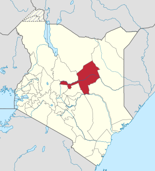
Homa Bay County is a county in the former Nyanza Province of Kenya. Its capital and largest town is Homa Bay. The county has a population of 1,131,950 and an area of 3,154.7 km2. Lake Victoria is a major source of livelihood for Homa Bay County. It has 40 wards, each represented by an MCA in the Homa Bay county assembly located in Homa Bay town, which is the county headquarters.
Mandera County is one of the counties in Kenya that has its capital and largest town as Mandera. The county is bordered by Ethiopia to the north, Somalia to the east and Wajir County to the southwest. According to the 2019 census, the county has a population of 1,200,890 and an area of 25,939.8 square kilometres (10,015.4 sq mi). The main economic activity in the county is pastoralism, while others include cross-border trade with Ethiopia, artisanal mining, beekeeping, and agriculture along the Dawa River.

The constituencies of Kenya are used to elect members of the National Assembly, the lower chamber of the Kenyan Parliament. In accordance with Article 89 of the 2010 Constitution of Kenya, there are 290 constituencies, based on a formula where these constituencies were to be delineated based on population numbers. Each constituency returns one Member of Parliament. The constituencies are further divided to electoral wards.
Cherangany Constituency, comprises the larger Trans Nzoia East District; otherwise known as Cherangani Sub-County, with an approximate area of 556.9 square km. It is an electoral constituency in Kenya, which was established/created for the 1988 general election.
Bomachoge is a former electoral constituency in Kenya. It was one of three constituencies in the now defunct Gucha District. The constituency was established for the 1988 elections. It has now been split into Bomachoge Borabu Constituency and Bomachoge Chache Constituency, both in Kisii County.
North Mugirango is one of four constituencies in Nyamira County. In 1966 the North Mugirango Constituency was split into West Mugirango and a smaller North Mugirango. The name was changed to Borabu / North Mugirango Constituency in 1974. In 1987 the name changed back to North Mugirango. Prior to 2013, it was formally known as North Mugirango (Borabu) Constituency.

Kisii County is a county in the former Nyanza Province in southwestern Kenya. Its capital and largest town is Kisii. The county has a population of 1,266,860 people. It borders Nyamira County to the North East, Narok County to the South, and Homa bay and Migori Counties to the West. The county covers an area of 1,318 km2.
Suba South, formerly Gwasi is an electoral constituency in Kenya. It is one of eight constituencies in Homa Bay County. The current member of Parliament is Caroli Omondi. He was elected on an ODM ticket.
Kitutu Chache North is a constituency in Kenya. It is one of nine constituencies in Kisii County.
Bomachoge Chache is a constituency in Kenya.
Embakasi North is a constituency in Kenya and one of the seventeen constituencies in Nairobi County. Embakasi North includes five electoral wards: Kariobangi North, Dandora Area I, Dandora Area II, Dandora Area III, and Dandora Area IV. The constituency has an area of 5.50 km2 (2.1 sq mi). It was created prior to the 2013 election when Kasarani Constituency and Embakasi Constituency boundaries were revised. The constituency forms part of two sub-counties of Nairobi; Kariobangi North falls under Kasarani while the Dandora area is in Njiru.
Borabu is a constituency in Kenya. It is one of the four constituencies in Nyamira County. It was established prior to the 2013 general elections. It was initially part of North Mugirango Constituency.
Kitutu Chache South is a constituency in Kenya. It is one of nine constituencies in Kisii County.
Mathare is a constituency in Nairobi. It is one of seventeen constituencies in Nairobi City County. It was created prior to the 2013 general election, when Starehe Constituency boundaries were revised. It is the smallest constituency in Nairobi with an area of 3.00 km2 (1.2 sq mi). It borders Ruaraka Constituency to the north; Roysambu and Westlands constituencies to the northwest; Embakasi Central Constituency to the east; Kamukunji Constituency to the south; and Starehe Constituency to the west.
