
Yolo County, officially the County of Yolo, is a county located in the northern portion of the U.S. state of California. Yolo County was one of the original counties of California, created in 1850 at the time of statehood. As of the 2020 census, the population was 216,403. Its county seat is Woodland.

Smith County is a county in the U.S. state of Texas. As of the 2020 census, its population was 233,479. Its county seat is Tyler. Smith County is named for James Smith, a general during the Texas Revolution.

Hidalgo County is located in the U.S. state of Texas. The county seat is Edinburg and the largest city is McAllen. The county is named for Miguel Hidalgo y Costilla, the priest who raised the call for Mexico's independence from Spain. It is located in the Rio Grande Valley of South Texas and is one of the fastest-growing counties in the United States. As of the 2020 census, its population was 870,781, making it the ninth-most populous county in Texas, and the most populous county outside of the counties in the Texas Triangle. Hidalgo County is designated by the U.S. Census Bureau as the McAllen–Edinburg–Mission metropolitan statistical area, which itself is part of the McAllen-Edinburg-Mission-Rio Grande City, Texas combined statistical area with neighboring Starr County.
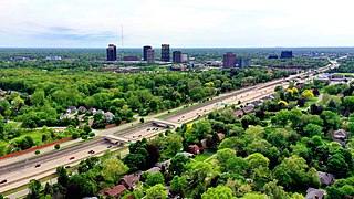
Oakland County is a county in the U.S. state of Michigan. It is a principal county of the Detroit metropolitan area, containing the bulk of Detroit's northern suburbs. Due to the county's government complex spanning 2 municipalities, its county seat is shared between Pontiac and Waterford. Its largest city is Troy. As of the 2020 Census, its population was 1,274,395, making it the second-most populous county in Michigan, and the largest county in the United States without a city of 100,000 residents.
Carol Stream is a village in DuPage County, Illinois, United States, and a suburb of Chicago. Carol Stream was incorporated on January 5, 1959, and named after its founder's daughter. Per the 2020 census, the population was 39,854.

Algonquin is a village in McHenry and Kane counties, Illinois, in the United States. It is a suburb of Chicago, located approximately 40 miles (64 km) northwest of the Loop. As of the 2020 census, the village's population was 29,700.

Penn Hills is a township with home rule status in Allegheny County, Pennsylvania, United States. The population was 41,059 as of the 2020 census. A suburb of Pittsburgh, Penn Hills is the second-largest municipality in Allegheny County.

Scarborough is a district of Toronto, Ontario, Canada. It is situated atop the Scarborough Bluffs in the eastern part of the city. Its borders are Victoria Park Avenue to the west, Steeles Avenue and the city of Markham to the north, Rouge River and the city of Pickering to the east, and Lake Ontario to the south. Scarborough was named after the English town of Scarborough, North Yorkshire, inspired by its cliffs.

Wayanad is a district in the north-east of the Indian state of Kerala, with administrative headquarters at the municipality of Kalpetta. It is the only plateau in Kerala. The Wayanad Plateau forms a continuation of the Mysore Plateau, the southern portion of Deccan Plateau which links the Western Ghats with the Eastern Ghats. It is set high in the Western Ghats with altitudes ranging from 700 to 2,100 meters. Vellari Mala, a 2,240 m (7,349 ft) high peak situated on the trijunction of Wayanad, Malappuram, and Kozhikode districts, is the highest point in Wayanad district. The district was formed on 1 November 1980 as the 12th district in Kerala, by carving out areas from Kozhikode and Kannur districts. An area of 885.92 km2 in the district is forested. Wayanad has three municipal towns—Kalpetta, Mananthavady and Sulthan Bathery. There are many indigenous tribes in this area. The Kabini River, a tributary of Kaveri River, originates at Wayanad. Wayanad district, along with the Chaliyar valley in the neighbouring Nilambur in Malappuram district, is known for natural gold fields, which are also seen in other parts of the Nilgiri Biosphere Reserve. Chaliyar river, which is the fourth longest river of Kerala, originates on the Wayanad plateau. The historically important Edakkal Caves are located in Wayanad district.

Barrackpore is a city and a municipality of north suburban Kolkata and situated in North 24 Parganas district in the Indian state of West Bengal. The area is covered by Kolkata Metropolitan Development Authority (KMDA). It is the headquarters of the Barrackpore subdivision.

Etah district is one of the districts of Uttar Pradesh, India, since 1854. Etah City is the district headquarters. Etah district is a part of Aligarh Division.
Sirohi District is a district of Rajasthan state in western India. The city of Sirohi is the district headquarters.

Krishnagiri district is one of the 38 districts of the state of Tamil Nadu, in India. This district is carved out from Dharmapuri District by 2004. The municipal town of Krishnagiri is the district headquarters. In Tamil Nadu, e-Governance was first introduced at Krishnagiri district under the National e-Governance Project (NEGP) in revenue and social welfare departments on a pilot basis. The district is one of the largest producers of mangoes in India. As of 2011, the district had a population of 1,879,809 with a sex-ratio of 958 females for every 1,000 males. Hosur is the most populous town in the district.

Kulgam, known as Kolgom in Kashmiri, is a town, an administrative division and capital of the Kulgam district in the Indian union territory of Jammu and Kashmir. It is located at a distance of 67 km (42 mi) from the summer state capital of Jammu and Kashmir, Srinagar. The city is divided into 16 electoral wards that has a population of 23,584, of which 12,605 are males while 10,979 are females.

Srisailam is a census town in Nandyal district of the Indian state of Andhra Pradesh. It is the mandal headquarters of Srisailam mandal in Atmakur revenue division. It is located about 160 kilometres (99 mi) from the district headquarters Nandyal, 180 kilometres (112 mi) from Kurnool, and it is located about 264 kilometres (164 mi) from Vijayawada. The town is famous for the Mallikarjuna Jyotirlinga Temple and is one of the holy pilgrimage sites for the Shaivism and Shaktism sects of Hinduism. The town is classified as both a Jyotirlinga and a Shakti Pitha.
Kandi is a sub-divisional city and municipality in Murshidabad district in West Bengal, India. It is the headquarters of the Kandi subdivision and is located on the east bank of Kana Mayurakshi River. The town is known for being one of the oldest municipal bodies in India, having acquired municipality status in 1869. The area is also known as the 'rice store' of Murshidabad district, owing to its large production of rice.

The Central and Western District located on northwestern part of Hong Kong Island is one of the 18 administrative districts of Hong Kong. It had a population of 243,266 in 2016. The district has the most educated residents with the second highest income and the third lowest population due to its relatively small size.

Perinthalmanna is a major town and municipality in Malappuram district, Kerala, India. It serves as the administrative centre for the Perinthalmanna taluk, as well as a revenue division, a community development block, and a police sub-division bearing the same name. It was formerly the headquarters of Valluvanad Taluk, which was one of the two Taluks in the Malappuram Revenue Division of the erstwhile Malabar District during the British Raj. The city is located 23 kilometres (14 mi) southwest to the city of Malappuram at the centre of the Kozhikode–Malappuram–Perinthalmanna–Palakkad National Highway 966.

Didaur, also spelled Dedaur, is a village in Sataon block of Rae Bareli district, Uttar Pradesh, India. It is located 8 km from Raebareli on the road to Unnao, just east of the intersection with the road to Lalganj. It is near the right bank of the Sai river. As of 2011, Didaur has a population of 4,781 people, in 900 households. The village hosts two annual festivals: one is the Badhwapur-ka-Mela, which is dedicated to the worship of Nag Devta and is held on Bhadra Sudi 5, and the other is the Jhurhapur-ka-Mela, which is dedicated to worship of Rama and falls on Phalguna Sudi 8.

