
Arthur Harbour is a small harbour entered between Bonaparte Point and Norsel Point on the south-west coast of Anvers Island in the Palmer Archipelago of Antarctica.

The Snake River is a 126-mile-long (203 km) tributary of the Niobrara River. Entirely located within the Sandhills of north-central Nebraska, the Snake River rises near the eastern edge of Sheridan County. It flows eastward into Cherry County and passes along the southern edge of Samuel R. McKelvie National Forest. On the southeast edge of the national forest, the river is dammed to form Merritt Reservoir. At this point, the river makes a sharp turn to the north.

Hanner Fieldhouse is a 4,325-seat multi-purpose arena in Statesboro in the U.S. state of Georgia. It was built in 1969 and is home to the Georgia Southern University men's basketball, women's basketball and women's volleyball teams. It hosted the 1985 and 1992 Atlantic Sun Conference men's basketball tournaments.

Zorzor District is one of six districts located in Lofa County, Liberia. Zorzor is principal city of the county.

Virginia's 8th congressional district is a United States congressional district in the Commonwealth of Virginia. It comprises all of Arlington County, portions of Fairfax County and all of the independent cities of Alexandria and Falls Church.

Now merely a few buildings, South Spafford retains an old church, no longer in service for that purpose. The last service was held in October 1996 by Rev R. Bob Teachout. The place is most notable for its scenic situation in the high, remote Coldbrook Valley of the Town of Spafford.

Prince Roland Napoléon Bonaparte was a French prince and president of the Société de Géographie from 1910 until his death. He was the last direct descendant of Lucien Bonaparte, the genetically senior branch of the family since 1844.
Chaguaramas is a town in northern Venezuela, in the state of Guárico. It is the shire town of the Chaguaramas Municipality.

Nizinne is a village in the administrative district of Gmina Szczecinek, within Szczecinek County, West Pomeranian Voivodeship, in north-western Poland.

Paynesville is an unincorporated community in Alpine County, California. It is located on the Carson River a quarter mile (0.4 km) northeast of Woodfords, at an elevation of 5118 feet.
Spring Valley is an unincorporated community in El Dorado County, California. It is located 3 miles (4.8 km) east-northeast of Pollock Pines, at an elevation of 3779 feet.
Lords Lake National Wildlife Refuge is a National Wildlife Refuge in Bottineau and Rolette counties, North Dakota. It is managed under J. Clark Salyer National Wildlife Refuge.
Shenandoah Homesteads Project is an unincorporated community in Rappahannock County, in the U.S. state of Virginia.
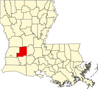
Bernard is an unincorporated community in Allen Parish, Louisiana, United States.
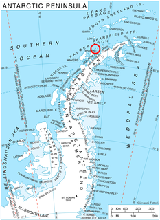
Garbel Point is the rocky point forming the west extremity of Liège Island in the Palmer Archipelago, Antarctica.
Young Hickory is an unincorporated community in Muskingum County, in the U.S. state of Ohio.
Roundup Creek is a stream in the U.S. state of South Dakota.

Redmon Park is an unincorporated community in Van Buren Township, Kosciusko County, in the U.S. state of Indiana.
Centerville is an unincorporated community in Douglas County, in the U.S. state of Nevada.


