Related Research Articles

The Gulf of St. Lawrence fringes the shores of the provinces of Quebec, New Brunswick, Nova Scotia, Prince Edward Island, Newfoundland and Labrador, in Canada, plus the islands Saint-Pierre and Miquelon, possessions of France, in North America.

Race Rocks Light is one of the first two lighthouses that were built on the west coast of Canada, financed by the British Government and illuminated in 1860. It is the only lighthouse on that coast built of rock, (granite) purportedly quarried in Scotland, and topped with sandstone quarried on Gabriola Island. The Islands of Race Rocks are located just off the southern tip of Vancouver Island, about 16 km (10 mi) southwest of Victoria, British Columbia.

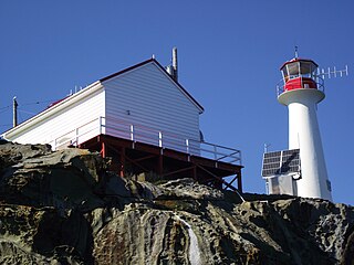
Cape Beale Lightstation is an active manned lighthouse on Vancouver Island in British Columbia, Canada.

The British Columbia Coast, popularly referred to as the BC Coast or simply the Coast, is a geographic region of the Canadian province of British Columbia. As the entire western continental coastline of Canada along the Pacific Ocean is in the province, it is synonymous with being the West Coast of Canada.
The Langara Point Lighthouse is a staffed lighthouse located atop a scenic bluff on the northwest corner of Langara Island. It is one of only two lighthouses in Haida Gwaii – the other being at Cape St. James, at the southern tip of the islands. Both were built in 1913.

Pitt Island is an island located on the north coast of British Columbia, Canada.

Burnt Islands is a small coastal community found in God Bay on the southwest coast of Newfoundland, Canada.

Banks Island is an island on the coast of the Canadian province of British Columbia. It is located south of Prince Rupert, on Hecate Strait, east of and opposite Haida Gwaii. To its east is Pitt Island and McCauley Island, both across Principe Channel. To its west is Bonilla Island. To its south lies the archipelago of the Estevan Group, beyond which is Caamaño Sound.

Campania Island is an island on the coast of the Canadian province of British Columbia. It is located south of Prince Rupert, east across Hecate Strait from Haida Gwaii. To its west, across Estevan Sound, is the Estevan Group archipelago. Banks Island lies to the northwest, across Nepean Sound; and Pitt Island to the north, across Otter Channel. To the northeast, across Squally Channel, is Gil Island, and to the east is Princess Royal Island, across Campania Sound. To the south of Campania Island is Caamaño Sound, beyond which is Aristazabal Island.
The Hartley Bay Indian Band is also known as the Gitga'at First Nation or the Hartley Bay First Nation. The members of the Gitga'at First nation are often referred to as Gitka'a'ata. The population of Gitk’a’ata peoples living in Hartley Bay ranges from approximately 130-200 people. There are also about 400-500 Gitk’a’ata peoples living in Prince Rupert, British Columbia, Canada, a neighboring territory. The Gitk’a’ata people have lived in Hartley Bay for hundreds of years, if not always. Some notable things regarding the Gitga'at First Nation are their economy, geography, government, sports involvement, COVID-19 regulations, and relations.

Ivory Island Lightstation is located 14 miles northwest of Bella Bella on the junction of Seaforth Channel and Milbanke Sound on the Inside Passage of British Columbia.

Entrance Island is a small rocky island in the Strait of Georgia, 841 metres (2,759 ft) due north of Gabriola Island. Marine mammals such as harbour seals and Steller's sea lions use it as a haul-out.
Chrome Island Lighthouse is a light station established in 1891 that assists traffic in the region of Deep Bay, British Columbia, Denman Island, and Hornby Island. It is currently a manned station, though in recent years the Canadian Coast Guard has considered automating it.

Triple Island Lighthouse is a large, manned light station on Triple Island. Built in 1920 after four years of construction, the concrete station features a 21.9 metres (72 ft) tower attached to a rectangular concrete structure that houses the keepers' quarters and machinery. A Triple Island helipad occupies much of the remainder of the islet. Canadian Coast Guard personnel man the station on a 28-day rotation. The station was designated a National Historic Site of Canada in 1974.
The Lucy Islands are a small archipelago off the North Coast of the province of British Columbia in Canada. The low-lying and heavily forested group, named after its largest island, Lucy Island, constitutes a provincially protected conservancy area that contains some of the North Coast's oldest archeological sites, a nationally significant seabird population, and a prominent 20th-century lighthouse.
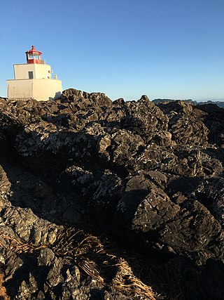
Amphitrite Point Lighthouse is an active lighthouse in Ucluelet on the west coast of Vancouver Island in British Columbia, Canada, named after Amphitrite, the sea goddess and wife of Poseidon in Greek mythology. It is also known for one of the sample pictures in Windows 7.

Marine Protected Areas (MPAs) (French: zones de protection marine) are zones within Canadian waters where the marine environment receives a high level of environmental protection. Marine Protected Areas are governed by the Oceans Act of 1996 and administered by Fisheries and Oceans Canada. The federal government of Canada has committed to protecting 25% of its oceans as Marine Protected Areas by the year 2025, and a further 5% (30% of the ocean area of the Exclusive Economic Zone) by 2030.
The British Columbia Shore Station Oceanographic Program is a sea surface temperature and salinity monitoring program on the Canadian coast of the northeast Pacific Ocean. The program is administered by Fisheries and Oceans Canada, and regroups 12 lighthouse stations in British Columbia. Most lighthouses are staffed by the Department of Fisheries and Oceans, but some have independent contractors instead.
The Banks Nii Łuutiksm Conservancy is located at the northern end of Banks Island along the coast of British Columbia, Canada.
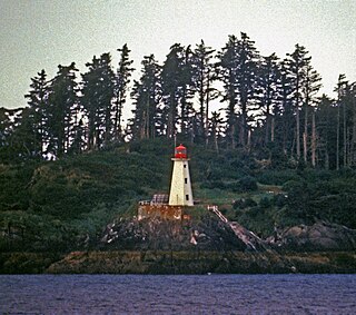
The Lax Kul Nii Luutiksm/Bonilla Conservancy was established in 2006 surrounding Bonilla Island, located along the North Coast of British Columbia, Canada.
References
- ↑ "Lax Kul Nii Luutiksm/Bonilla Conservancy". bcparks.ca. B.C. Parks. Retrieved 21 June 2023.
- ↑ "Bonilla Island Lighthouse". LighthouseFriends. Retrieved 2017-09-06.
- ↑ Fisheries and Oceans Canada (2019-03-21). "Data from BC lightstations". www.dfo-mpo.gc.ca. Fisheries and Oceans Canada. Archived from the original on 2019-06-19. Retrieved 2021-02-11.
- ↑ "Bonilla Island AUT". Canadian Climate Normals 1991–2020. Environment and Climate Change Canada. Climate ID: 1060R0K. Retrieved 2024-11-07.