
The Kootenay River or Kootenai River is a major river of the Northwest Plateau in southeastern British Columbia, Canada, and northern Montana and Idaho in the United States. It is one of the uppermost major tributaries of the Columbia River, the largest North American river that empties into the Pacific Ocean. The Kootenay River runs 781 kilometres (485 mi) from its headwaters in the Kootenay Ranges of the Canadian Rockies, flowing from British Columbia's East Kootenay region into northwestern Montana, then west into the northernmost Idaho Panhandle and returning to British Columbia in the West Kootenay region, where it joins the Columbia at Castlegar.

Kootenay Lake is a lake located in British Columbia, Canada. It is part of the Kootenay River. The lake has been raised by the Corra Linn Dam and has a dike system at the southern end, which, along with industry in the 1950s–70s, has changed the ecosystem in and around the water. The Kootenay Lake ferry is a year-round toll-free ferry that crosses between Kootenay Bay and Balfour. The lake is a popular summer tourist destination.
Syringa Park is a provincial park on the east shore of Lower Arrow Lake in the West Kootenay region of southeastern British Columbia. At the foot of the Norns Range, Tulip Creek passes through the centre, and Syringa Creek is closer to the southeastern boundary. The park is about 19 kilometres (12 mi) west of Castlegar via Broadwater Rd.

Montrose is in the West Kootenay region of southeastern British Columbia. The village lies 7 kilometres (4 mi) east of the city of Trail along Highway 3B.

Fruitvale is a village in the West Kootenay region of southeastern British Columbia. It is 16 km (9.9 mi) east of the city of Trail along Highway 3B.
Warfield is a village at the bottom of the Rossland hill, immediately west of Trail, in the West Kootenay region of southern British Columbia.

The Village of Slocan is in the West Kootenay region of southeastern British Columbia. The former steamboat landing and ferry terminal is at the mouth of Springer Creek, at the foot of Slocan Lake. The locality, on BC Highway 6 is about 69 kilometres (43 mi) by road north of Castlegar and 183 kilometres (114 mi) by road and ferry south of Revelstoke.
Chats Falls were a set of waterfalls on the Ottawa River, near Fitzroy Harbour, Ontario, and Quyon, Quebec, Canada. A hydroelectric generating station is now located here, owned and operated jointly by Hydro-Québec and Ontario Power Generation. It lies within the cities of Ottawa, Ontario and Pontiac, Quebec.
FortisBC is a Canadian owned, British Columbia based regulated utility providing natural gas, and electricity. FortisBC has approximately 2,600 employees serving more than 1.2 million customers in 135 B.C. communities and 58 First Nations communities across 150 Traditional Territories.
The Duncan River is in the West Kootenay region of southeastern British Columbia. Entering the North Arm of Kootenay Lake, the river is a major tributary of the Kootenay River, which in turn flows into the Columbia River. The Selkirk Mountains lie to the west and the Purcell Mountains to the east.

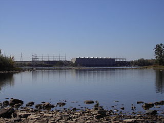
Corra Linn Dam is a concrete hydroelectric dam on the Kootenay River between the cities of Castlegar and Nelson, in the West Kootenay region of southern British Columbia.
The Clowhom River is a short, 19.8-kilometre (12.3 mi) river in British Columbia. It flows into the head of the Salmon Inlet about 26.2 km west of Squamish.
Comaplix was a former mining town on the Incomappleux River in the Upper Arrow Lake area of the West Kootenay region of British Columbia. The name of the town and an adjacent mountain and creek derived from the river. Cleared in 1896, the town was surveyed and a sawmill established the next year. The suspicious 1915 fire, which levelled the buildings, largely ended the flourishing hamlet. The site, north of Beaton, on the northeast side of the lake's Beaton Arm, comprised merely concrete foundations when the Keenleyside Dam reservoir submerged the area in 1968. The small overgrown cemetery above the townsite is all that remains.

The Kootenay Canal is a hydroelectric power station, located 19 km downstream of Nelson, British Columbia, Canada. Where the Kootenay River flows out of the reservoir formed by the Corra Linn Dam on Kootenay Lake., a canal diverts water to BC Hydro's Kootenay Canal Generating Station. Its construction was a result of the Duncan Dam and Libby Dam providing year round flows into Kootenay Lake. The powerhouse was completed in 1976.
Columbia Gardens is in the West Kootenay region of southern British Columbia. The locality is east of Trail, and near the Boundary-Waneta Border Crossing.
Lemon Creek is an unincorporated community on the east side of the Slocan River in the West Kootenay region of southeastern British Columbia. The locality is on BC Highway 6 about 8 kilometres (5 mi) south of Slocan, and 62 kilometres (39 mi) north of Castlegar.
Bonnington Falls is a community on the north side of the Kootenay River between the cities of Castlegar and Nelson, in the West Kootenay region of southern British Columbia. It was named after the adjacent Bonnington Falls, now submerged by hydro dams.
South Slocan is an unincorporated community in rural British Columbia with a population of approximately 100 people, many of whom are followers of the Doukhobors religion. It is located on the northwest shore of the Kootenay River in the West Kootenay region of southeastern British Columbia. The village comprises 51 households. A former railway junction on BC Highway 6, it is approximately 24 kilometres (15 mi) northeast of Castlegar, and 20 kilometres (12 mi) southwest of Nelson. Its postal category is Rural Route One.
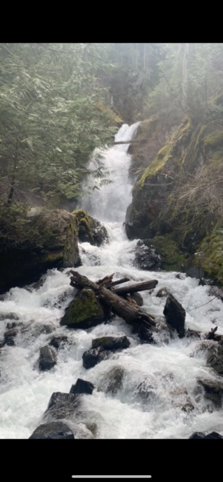
Stewart Creek is a small creek in the Regional District of Central Kootenay in the West Kootenay region of British Columbia, Canada. The creek is a tributary of the Salmo River and has its source in the Selkirk Mountains close to the town of Ymir. The name was adopted in 1930. Its source is the peaks of Round Mountain, the same source as that of Quartz Creek and is approximately 2 km north of Ymir. There is a rest area featuring a small waterfall with a picnic area on Highway 6 at Stewart Creek.

Hall is a small community in the Selkirk Mountains in the West Kootenay region of the Regional District of Central Kootenay in British Columbia, Canada, south of Nelson and north of Ymir. Hall Creek flows into the Salmo River in the community. British Columbia Highway 6 runs through it.

