The Turks and Caicos Islands are a British Overseas Territory consisting of the larger Caicos Islands and smaller Turks Islands, two groups of tropical islands in the Lucayan Archipelago of the Atlantic Ocean and northern West Indies. They are known primarily for tourism and as an offshore financial centre. The resident population in 2023 was estimated by The World Factbook at 59,367, making it the third-largest of the British overseas territories by population. However, according to a Department of Statistics estimate in 2022, the population was 47,720.

The Bahamas are a group of about 700 islands and cays in the western Atlantic Ocean, of which only between 30 and 40 are inhabited. The largest of the islands is Andros Island, located north of Cuba and 200 kilometres southeast of Florida. The Bimini islands are to its northwest. To the North is the island of Grand Bahama, home to the second-largest city in the country, Freeport. The island of Great Abaco is to its east. In the far south is the island of Great Inagua, the second-largest island in the country. Other notable islands include Eleuthera, Cat Island, San Salvador Island, Acklins, Crooked Island, and Mayaguana. Nassau is the capital and largest city, located on New Providence. The islands have a tropical savannah climate, moderated by the Gulf Stream. The total size is 13,878 km2 (5,358 sq mi). Due to the many widespread islands it has the 41st largest Exclusive Economic Zone of 654,715 km2 (252,787 sq mi).
This article talks about transportation in the Bahamas, a North American archipelagic state in the Atlantic Ocean.
The Lucayan people were the original residents of The Bahamas and the Turks and Caicos Islands before the European colonisation of the Americas. They were a branch of the Taínos who inhabited most of the Caribbean islands at the time. The Lucayans were the first Indigenous Americans encountered by Christopher Columbus. Shortly after contact, the Spanish kidnapped and enslaved Lucayans, with the displacement culminating in the complete eradication of the Lucayan people from the Bahamas by 1520.

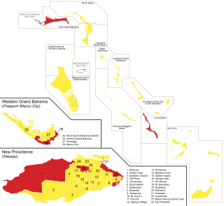
Local government in The Bahamas exists at two levels: 32 districts and 41 towns. The boundaries of districts are defined by the First Schedule of The Bahamas Local Government Act 1996, defined with reference to parliamentary constituency boundaries. The Second Schedule lists 13 districts which are divided into town areas. Towns are governed by directly elected town committees. Second Schedule districts are governed by nine-person district councils composed of the chairs of the town committees, and if numerically required, additional people elected by the town committees. The 19 Third Schedule districts are unitary authorities which cannot be divided into towns. They are governed by nine-person district councils which are directly elected by voters. The powers of Second Schedule and Third Schedule councils are slightly different, and the Third Schedule district known as the City of Freeport has a slightly different list of enumerated powers.

The Abaco Islands lie in the northern Bahamas, about 193 miles east of Miami, Florida. The main islands are Great Abaco and Little Abaco, which is just west of Great Abaco's northern tip. There are several smaller barrier cays, of which the northernmost are Walker's Cay and its sister island Grand Cay. To the south, the next inhabited islands are Spanish Cay and Green Turtle Cay, with its settlement of New Plymouth, Great Guana Cay, private Scotland Cay, Man-O-War Cay, and Elbow Cay, with its settlement of Hope Town. Southernmost are Tilloo Cay and Lubbers Quarters. Also of note off Abaco's western shore is Gorda Cay, now a Disney-owned island and cruise ship stop renamed Castaway Cay. Also in the vicinity is Moore's Island. On the Big Island of Abaco is Marsh Harbour, the Abacos' commercial hub and the Bahamas' third-largest city, plus the resort area of Treasure Cay. Both have airports. A few mainland settlements of significance are Coopers Town and Fox Town in the north and Cherokee and Sandy Point in the south. Administratively, the Abaco Islands constitute seven of the 31 Local Government Districts of the Bahamas: Grand Cay, North Abaco, Green Turtle Cay, Central Abaco, South Abaco, Moore's Island, and Hope Town.

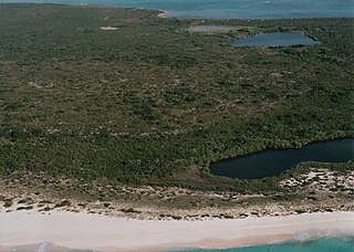
Mayaguana is the easternmost island and district of The Bahamas. Its population was 277 in the 2010 census. It has an area of about 280 km2 (110 sq mi).

Ragged Island is a 23 km2 (8.9 sq mi) island and district in the southern Bahamas. Ragged Island is part of the Jumentos Cays and Ragged Island Chain. The crescent-shaped chain measures over 180 km (110 mi) in length and includes cays known as Raccoon Cay, Hog Cay and Double-Breasted Cay. Island ownership is stated to have been granted to William George Lockhart some time in the 18th century. On 8 September 2017, Duncan Town took a direct hit from Hurricane Irma.

The Plana Cays are a group of two small uninhabited islands in the southern Bahama Islands, located east of Acklins Island and west of Mayaguana Island. The indigenous Lucayan people called the islands Amaguaya, meaning "toward the middle lands".
The majority of the population of the Turks and Caicos Islands are Christian. They include Protestant 72.8%, Baptists 35.8%, Church of God 11.7%, Roman Catholics 11.4%, Anglicans 10%, Methodists 9.3%, Seventh-Day Adventists 6%, Jehovah's Witnesses 1.8%, and Other 14%
Flamingo Air is a small airline in the Bahamas. Its base of operations is the Grand Bahama International Airport in Freeport. It also has offices in Marsh Harbour Abaco Airport, in Bimini International Airport, and in the Lynden Pindling International Airport, Nassau. It provides scheduled service to several islands, as well as Air Charter service to the Bahamas and south Florida. The airline is currently grounded after a number of incidents in recent years. The Bahamian authorities have said they will keep all the aircraft grounded until inspections of Flamingo Air's maintenance and investigation into their safety practices are completed.

The Bahamian hutia or Ingraham's hutia is a small, furry, rat-like mammal found only in the Bahamas. About the size of a rabbit, it lives in burrows in forests or shrubland, emerging at night to feed on leaves, fruit, and other plant matter. It was believed extinct until rediscovery in 1964, and it remains the focus of conservation efforts. The Bahamian hutia is a member of the hutia subfamily (Capromyinae), a group of rodents native to the Caribbean, many of which are endangered or extinct.
Cyclura carinata bartschi, commonly known as Bartsch's iguana or the Booby Cay iguana, is a subspecies of lizard in the family Iguanidae. The subspecies is endemic to a single cay, Booby Cay, in The Bahamas.

The following outline is provided as an overview of and topical guide to The Bahamas:

The following is an alphabetical list of topics related to the Commonwealth of The Bahamas.
Sphaerodactylus mariguanae, also known as the southern Bahamas sphaero or Mayaguana least gecko, is a species of lizard in the family Sphaerodactylidae. It is endemic to Mayaguana and Booby Cay in the Bahamas.

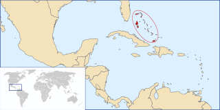
The Bahama Archipelago, also known as the Lucayan Archipelago, is an island group comprising the Commonwealth of The Bahamas and the British Overseas Territory of the Turks and Caicos Islands. The archipelago is in the western North Atlantic Ocean, north of Cuba along with the other Antilles, and east and southeast of Florida. The archipelago has experienced the effects of at least 22 Atlantic hurricanes, or storms that were once tropical or subtropical cyclones, including 17 since 2000. The storms collectively killed 101 people.
LeAir Charter Services Ltd. is a small regional airline based in Nassau, Bahamas, at Lynden Pindling International Airport (LPIA). The company was founded in 1996.

Mayaguana, Inagua, Crooked Island, Acklins and Long Cay, abbreviated as MICAL, is a parliamentary constituency represented in the House of Assembly of the Bahamas.


