Related Research Articles
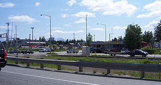
Willow is a census-designated place (CDP) in the Matanuska-Susitna Borough in the U.S. state of Alaska. Located 26 miles northwest from Wasilla along the George Parks Highway, it is part of the Anchorage, Alaska Metropolitan Statistical Area. At the 2020 census the population was 2,196, up from 2,102 in 2010.

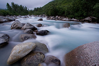
The Susitna River is a 313-mile (504 km) long river in the Southcentral Alaska. It is the 15th largest river in the United States, ranked by average discharge volume at its mouth. The river stretches from the Susitna Glacier to Cook Inlet's Knik Arm.

Eklutna is a native village within the Municipality of Anchorage in the U.S. state of Alaska. The Tribal Council estimates the population at 70; many tribal members live in the surrounding communities.

Cook Inlet stretches 180 miles (290 km) from the Gulf of Alaska to Anchorage in south-central Alaska. Cook Inlet branches into the Knik Arm and Turnagain Arm at its northern end, almost surrounding Anchorage. On its southern end, it merges with Shelikof Strait, Stevenson Entrance, Kennedy Entrance and Chugach Passage.
Turnagain Arm is a waterway into the northwestern part of the Gulf of Alaska. It is one of two narrow branches at the north end of Cook Inlet, the other being Knik Arm. Turnagain is subject to climate extremes and large tide ranges.

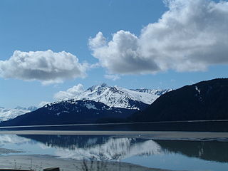
Girdwood is a resort town within the southern extent of the Municipality of Anchorage in the U.S. state of Alaska. Located near the end of the Turnagain Arm of Cook Inlet, Girdwood lies in a valley in the southwestern Chugach Mountains, surrounded by seven glaciers feeding into a number of creeks, which either converge within the valley or empty directly into the arm. Girdwood is typically accessed by the Seward Highway, with the main line of the Alaska Railroad paralleling the highway. By road distance, most of the community lies within 35 to 40 miles of Downtown Anchorage. The 2019 American Community Survey estimates a population of 1,742 in the valley.

Chugach State Park covers 495,204 acres covering a hilly region immediately east of Anchorage, in south-central Alaska.
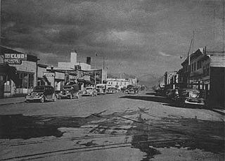
After congress approved the completion of the Alaska Railroad from Seward to Fairbanks in 1914, it was decided that a new town should be built as a port and rail hub along the route. The decision was made to develop a site near Ship Creek on Cook Inlet. Survey parties visited the area in 1914 and researched possible routes for the rails and options for siting the new town. Anchorage was originally settled as a tent city near the mouth of Ship Creek in 1915, and a planned townsite was platted alongside the bluff to the south. Anchorage was mostly a company town for the Alaska Railroad for its first several decades of existence.
The Knik River is a 25-mile-long (40 km) river in the U.S. state of Alaska. Its source is at Knik Glacier, from which it flows northwest and west and empties into the head of Cook Inlet's Knik Arm, near the mouth of the Matanuska River. It is bridged twice where the Old Glenn Highway crosses it near the Butte, and also bridged on the Hayflats.
Little Susitna River (Dena'ina: Tsałtastnu) heads at Mint Glacier on Montana Peak, in Talkeetna Mountains at 61°51′30″N149°03′30″W, flows southwest to Cook Inlet, 13 miles (21 km) west of Anchorage, Alaska Cook Inlet Low.

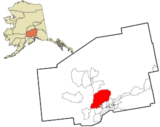
The Municipality of Anchorage is the largest city in the U.S. state of Alaska by population. With a population of 291,247 at the 2020 census, it contains nearly 40 percent of the state's population, and has more people than all of Northern Canada and Greenland combined. The Anchorage metropolitan area, which includes Anchorage and the neighboring Matanuska-Susitna Borough, had a population of 398,328 in 2020, accounting for more than half the state's population. At 1,706 sq mi (4,420 km2) of land area, the city is the fourth-largest by area in the United States and larger than the smallest state, Rhode Island, which has 1,212 sq mi (3,140 km2).
Alexander is an unincorporated community in Matanuska-Susitna Borough, Alaska, United States. An Alaska Native community with an Alaska Native Village Corporation, it lies on the Susitna River delta, near the mouth of Alexander Creek, and 27 miles (43 km) northwest of Anchorage, Alaska Cook Inlet Low. It is located within the boundaries of Susitna CDP.
The City of Wasilla (Dena'ina: Benteh) is a city in Matanuska-Susitna Borough, United States and the fourth-largest city in Alaska. It is located on the northern point of Cook Inlet in the Matanuska-Susitna Valley of the southcentral part of the state. The city's population was 9,054 at the 2020 census, up from 7,831 in 2010. Wasilla is the largest city in the borough and a part of the Anchorage metropolitan area, which had an estimated population of 398,328 in 2020.
The Portage Glacier Highway, or Portage Glacier Road, is a highway located in the U.S. state of Alaska. The highway is made up of a series of roads, bridges, and tunnels that connect the Portage Glacier area of the Chugach National Forest and the city of Whittier to the Seward Highway. Most of the highway travels through mainly rural areas just north of the Kenai Peninsula, with the Anton Anderson Memorial Tunnel passing under Maynard Mountain, part of the Chugach Mountain Range. Parts of the route were first constructed in the early 1900s, and the entire highway was completed on June 7, 2000, as part of the Whittier Access Project. The main portion of the highway traveling from the western terminus to the Begich, Boggs Visitor Center at Portage Lake is designated as National Forest Highway 35 by the United States Forest Service (USFS).

The Anchorage Coastal Wildlife Refuge is a wildlife refuge located in the Anchorage Municipality.
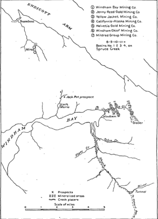
Windham Bay is located 45 miles (72 km) southeast of Juneau, in the U.S. state of Alaska. Windham Bay is listed as site 6 within Southeast Alaska's Zone 3 of the Alaska Dept. of Environmental Conservation's Geographic Response Strategy oil spill response plan. Part of the bay is a protected wilderness area; the Chuck River Wilderness, established in 1990 by the United States Congress, covers an area of 74,506 acres (30,152 ha). The Chuck River flows into Windham Bay, which has a protected anchorage north of Port Houghton, where the historic Chuck Mining Camp once operated.
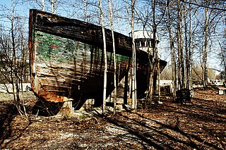
Chacon was a 72 ft (22 m) dry docked wooden vessel and roadside curiosity in Chugiak, Alaska, United States. The former cannery tender occupied a parcel at 17049 Old Glenn Highway until March 11, 2022, and served as a memorial to her former owner, Thillman Wallace of Chugiak (1932–2015).

Indian is a community in the Municipality of Anchorage, Alaska, United States. It lies in a valley in the Chugach Mountains near the middle of the north shore of the Turnagain Arm of Cook Inlet. It is about 24 miles (39 km) southeast of downtown Anchorage and about 3 miles (4.8 km) northwest of Bird, and about 13 miles (21 km) west-northwest of Girdwood.
Humpy Cove is an inlet of Resurrection Bay on the Kenai Peninsula of the U.S. state of Alaska. Located 11 miles from Seward, it has the shape of a whale's tail, and consists of two smaller bays. The cove is often used as an anchorage for recreational boaters. It received its name from the plentiful returns of pink salmon that spawn in Humpy Creek, the inflow of the southern bay. The cove is a popular tourist destination as well, due to Orca Island Cabins and kayak tours offered by Miller's Landing. Humpy Cove has runs of rockfish, halibut, coho salmon, chinook salmon, and chum salmon as well as pinks, and a popular fishing spot is near the Iron Door, the remains of a searchlight and bunker from World War II. The cove contains the only road on the Resurrection Peninsula, a stretch of pavement leading to the aforementioned searchlight.

The Westchester Lagoon is a combination of two artificial lakes which form a coastal lagoon near Downtown Anchorage, Alaska. On the lagoons western end, a raised, earthen levee offers right of way for the Alaska Railroad. The levee separates the lagoon from Cook Inlet's Knik Arm, although a large culvert allows spawning salmon swimming upstream from Cook Inlet to use the Chester Creek outflow they will find there. The Tony Knowles Coastal Trail system passes this end of the lagoon, before turning east and passing the Bootleggers Cove neighborhood to the north of the lagoon and continuing further inland into Anchorage. The lagoons eastern boundary is Spenard Road. To the south are single and multi-family homes, Hillcrest Drive and West Anchorage High School. The lagoon is bisected by Minnesota Drive, forming two distinct lakes.
References
- ↑ Aunt Phil's Trunk: Bringing Alaska's history alive! by Laurel Bill, Phyllis Carlson -- Aunt Phil's Trunk LLC 2016
- Municipality of Anchorage map [ permanent dead link ]
- Tower, Elizabeth (2003). Anchorage: from Its Humble Origins as a Railroad Construction Camp . Kenmore: Epicenter Press. ISBN 978-0-945397-72-4.
- O'Malley, Julia (September 11, 2007). "Second chance: Sister's killing had deadly echo". Anchorage Daily News. Retrieved January 9, 2008.[ permanent dead link ]
61°12′23″N149°55′52″W / 61.20639°N 149.93111°W
| | This article about a location in the Municipality of Anchorage, Alaska is a stub. You can help Wikipedia by expanding it. |