
Casa Conejo is an unincorporated county island in Newbury Park, Ventura County, California, United States. It was the first planned community in Newbury Park and began building in 1960. When the city of Thousand Oaks incorporated 4 years later, the new developments in Newbury Park were incorporated into the city boundaries before being subdivided. The community is bordered by Old Conejo Road and US 101 to the north, Borchard Road to the south, Jenny Drive to the west, and Sequoia Middle School to the east. For statistical purposes, the United States Census Bureau has defined Casa Conejo as a census-designated place (CDP). The census definition of the area may not precisely correspond to local understanding of the area with the same name. The population was 3,249 at the 2010 census, up from 3,180 at the 2000 census. Casa Conejo is located in a roughly rectangle-shaped unincorporated area surrounded by the city of Thousand Oaks.

Thousand Oaks is the second-largest city in Ventura County, California, United States. It is in the northwestern part of Greater Los Angeles, approximately 40 miles (64 km) from Downtown Los Angeles, and is less than 15 miles (24 km) from the Los Angeles neighborhood of Woodland Hills. It is named after the many oak trees present in the area.

The Conejo Valley is a region spanning both southeastern Ventura County and northwestern Los Angeles County in Southern California, United States. It is located in the northwestern part of the Greater Los Angeles Area.

Newbury Park is a populated place and town in Ventura County, California, United States. Most of it lies within the western Thousand Oaks city limits, while unincorporated areas include Casa Conejo and Ventu Park. About 28,000 residents of Thousand Oaks reside in Newbury Park. Newbury Park makes up around 40 percent of the total land area of Thousand Oaks. Lying within the Conejo Valley in the northwestern part of the Greater Los Angeles Area, Newbury Park abuts the Santa Monica Mountains. It is approximately 35 miles (56 km) from Downtown Los Angeles and less than 7 mi (11 km) from the Los Angeles County border in Westlake Village. The closest coastal city is Malibu, 22 mi (35 km), which may be reached through winding roads or hiking trails crossing the Santa Monica Mountains. It makes up all of ZIP code 91320, and is within area code 805.

Rancho Conejo Playfields is a 13 acres (5.3 ha) multi-use community park in Newbury Park, California, adjacent to Conejo Canyons Open Space and the Arroyo Conejo Nature Preserve which includes 302 acres (122 ha) of public open-space land and numerous trails in the western Simi Hills.

Walnut Grove Park is a 6.5 acre community park in Newbury Park, California, United States, situated immediately south of the U.S. 101 Ventura Freeway on Newbury Road. Named for its many walnut trees, the park land was acquired in 1981 and ultimately developed into a community park in 1994. It contains a playground, an outdoor handball court, three BBQ grills, basketball courts, numerous picnic tables, trails, and open-space. It is operated by the Conejo Recreation & Park District (CRPD), and it is adjacent to the Walnut Grove Equestrian Center and its 14 acres of trails, horse arenas, stalls, picnic tables, and various trails for hikers and equestrians. The park is relatively close to the Arroyo Conejo Open Space and its many trails leading for instance to Wildwood Regional Park, which is accessible from its closest trailhead between 507 Kalinda Pl. and 504 Paseo Grande on West Hillcrest Drive. Walnut Grove Park is located along a smaller offspring from the Arroyo Conejo, and is one of only three off-leash dog parks in the Conejo Valley.

Lynn Oaks Park is a seven-acre community park in the southern part of Newbury Park, CA, which includes trails to numerous surrounding nature areas, including but not limited to the Hope Nature Preserve, Hidden Valley, and the Santa Monica Mountains National Recreation Area. It was first developed as a community park in 1983 and is named for its many oak trees. The park contains a volleyball court, outdoor basketball court, soccer field, a playground, barbecue grills, water fountains and numerous picnic tables. Some of the trails include the shorter Spring Canyon Trail and Oak Creek Canyon Loop, while the Los Robles Trail connects Lynn Oaks Park to the Hope Nature Preserve and beyond to Hidden Valley and the Santa Monica Mountains National Recreation Area.
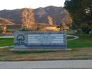
Hickory Park is a neighborhood park at the foothills of the Santa Monica Mountains, less than 500 feet from the Santa Monica Mountains National Recreation Area, in southern Newbury Park, California. It is a five-acre park, which includes facilities such as a playground, basketball courts, backstop, barbecue grills, picnic tables, trails, etc.

Rabbit Hill, also referred to as Knoll Hill, is a 797-foot high hill (243 m) located in Knoll Park, which is among the highest peaks in Newbury Park, California that are not parts of the Santa Monica Mountains. It is reached from a trailhead on North Reino Road, just across the road from the Pepper Tree Playfields, which provides hikers to Rabbit Hill with parking spaces. The sloping Knoll Trail goes from N. Reino Rd. to the top of the knoll, which offers panoramic views of Newbury Park, Casa Conejo, Boney Mountain, Thousand Oaks and Conejo Mountain. The total park area is 21 acres (8.5 ha) including the hill, which is covered with coastal sage scrub and grassland.

Newbury Gateway Park is a seven-acre neighborhood park, located across the street from Newbury Park Library in western Newbury Park, California. The most notable attraction here includes the endemic plant and tree species, including an oak grove with over a hundred planted native oak trees. It contains picnic areas, a playground, turf area, and seating benches. First acquired in 1984, the open space area added four additional acres of land and was developed into a neighborhood park by the Conejo Recreation & Park District (CRPD) in cooperation with Thousand Oaks in 1999. Newbury Gateway Park was closed for nearly a year in the 2012-2013 period as a result of a major drainage problems.

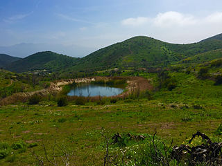
The Conejo Canyons Open Space consists of 1,628 acres (659 ha) of open-space areas in northernmost Newbury Park, Ventura County, California. It consists of deeply eroded canyons, numerous ridgelines and plateaus in the northwestern portion of the Conejo Valley. The area consists of diverse natural features such as deep canyons with perennial streams, prominent ridgelines, volcanic mountains, and a variety of natural habitats. While some of the flora includes chaparral, riparian habitats, oak woodlands and coastal sage, fauna includes mountain lions, coyotes, mule deer, and bobcats.

Banyan Park is a 7.4 acre community park at the foothills of the Santa Monica Mountains in southern Newbury Park, California. The park is approximately 800 feet from the Santa Monica Mountains National Recreation Area and is adjacent to the Banyan Elementary School. It was the first park to be acquired by the Conejo Recreation & Park District (CRPD) in 1964, and was later developed into a park in 1967. The park includes a hilltop gazebo, turf, picnic tables, barbecues, and playgrounds.

Cypress Park is a five-acre neighborhood park in southwestern Newbury Park, California. Acquired in 1969, the land was developed into a community park in 1973 with a baseball field, a playground, picnic tables, and bleachers. It is owned and operated by the Conejo Recreation & Park District (CRPD). Situated immediately south of Cypress Elementary School, the park is also home to several ponds and smaller creeks. It is used for bird-observations, recreational activities, picnicking, and camping.

Dos Vientos Community Park in southwestern Newbury Park, CA is the largest of Conejo Recreation & Park District’s public parks in the Conejo Valley. It is adjacent to the Dos Vientos Community Center, which offers a preschool, sports, and other activities. The park contains sand volleyball courts, baseball-, basketball- and tennis courts, soccer fields, playground areas, and picnic tables and barbecue grills. It is adjacent to the Dos Vientos Open Space through the Park View Trail, which is a 1,216 acre natural open-space, bordering an additional 16,000 acres of open space stretching over the Santa Monica Mountains National Recreation Area to the Pacific Ocean. The Park View Trail ends at Via Ricardo, directly across the road from the Powerline Trail and Dos Vientos Open Space.

Pepper Tree Playfield is a 21.7-acre community park located in western Newbury Park, California. It is located at the corner of Reino and Old Conejo Roads, and was acquired by the Conejo Recreation & Park District (CRPD) in 1977, but not developed nor opened until 1983. It contains a 0.83-mile fitness trail loop, and is nearby numerous trailheads. The park is within walking distance from the Conejo Vista Trailhead in Old Conejo Open Space, located immediately north of Pepper Tree Playfield, and the park is directly across the street from the Knoll Trailhead in Knoll Open Space, which is to the park’s immediate east, crossing North Reino Road. It is also an access point for trails leading to the Conejo Mountain. Pepper Tree Playfield is named for its many pepper trees, which surrounds the park area.

Ventu Park Open Space is a 141-acre open space area in Newbury Park, California. Its primary features are the Rosewood Trail leading to Angel Vista, a 1,603 ft peak in the Santa Monica Mountains. Parking for the Rosewood Trail is located at the Stagecoach Inn Park, across Lynn Road from the primary trailhead. The Rosewood Trail begins with oak woodland and crosses a creek at the canyon floor, before climbing up towards the steep Angel Vista Point. There are 360-degree panoramic views of the Conejo Valley, the Oxnard Plain, the California Channel Islands, Pacific Ocean, Point Mugu, Hidden Valley, as well as the Santa Monica-, Santa Susana- and Topa Topa Mountains.
Dos Vientos is a neighborhood in westernmost Newbury Park, California, which borders Dos Vientos Open Space and the Santa Monica Mountains. It was a 2,350-unit housing development which was approved by the Thousand Oaks City Council in April 1988. It is an upscale and master-planned community. Major development found place after infrastructure was built to support the homes in 1998. It was the largest residential project ever within Newbury Park. It has a maximum elevation of 2,500 feet.

Conejo Recreation and Park District (CRPD) is the park management agency for most of the parks in the Conejo Valley, California. Established in 1962, CRPD later established Conejo Open Space Conservation Agency (COSCA) in 1977 through a joint effort with the City of Thousand Oaks. COSCA administers over 15,000 acres of open space and 140 miles of trails, while CRPD administers over 50 community parks. CRPD's annual operating budget is $20,000,000, of which about 70% are from property taxes.
Newbury Road is the main street in Newbury Park, California, and runs parallel to the U.S. Route 101. The road is named for the town’s founder, Egbert Starr Newbury. The historic Newbury Park Post Office has had several locations on Newbury Road, including at the Stagecoach Plaza, a shopping complex with a name that implies the stagecoach heritage of the area. Stagecoach Plaza houses 14 restaurants and shops, and it is adjacent to additional shops on both sides.

