
The Siegfried Line, known in German as the Westwall, was a German defensive line built during the 1930s opposite the French Maginot Line. It stretched more than 630 km (390 mi) from Kleve on the border with the Netherlands, along the western border of Nazi Germany, to the town of Weil am Rhein on the border with Switzerland. The line featured more than 18,000 bunkers, tunnels and tank traps.
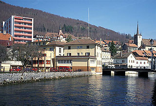
Vallorbe is a municipality in the district of Jura-Nord Vaudois in the canton of Vaud in Switzerland.

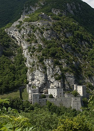
The Alpine Wall was an Italian system of fortifications along the 1,851 km (1,150 mi) of Italy's northern frontier. Built in the years leading up to World War II at the direction of Italian dictator Benito Mussolini, the defensive line faced France, Switzerland, Austria, and Yugoslavia. It was defended by the "Guardia alla Frontiera" (GaF), Italian special troops.

The Fort Hommet 10.5 cm coastal defence gun casemate bunker is a fully restored gun casemate that was part of Fortress Guernsey constructed by the forces of Nazi Germany between 1940 and 1945.

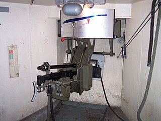
The M-19 Maschinengranatwerfer is a German 50 mm mortar which was used during World War II. The mortar was developed in 1934 for the purpose of defending permanent military bases. It had a maximum rate of fire of 120 rounds per minute and a range of 750 metres.

The Fort du Scex is a component of Fortress Saint-Maurice, which is in turn one of the three principal fortified regions of the National Redoubt of Switzerland. The Fort du Scex was built in the Scex cliff face immediately to the west of Saint-Maurice beginning in 1911. With the later Fort de Cindey, it comprises a fortress complex encased in rock high above the strategic Saint-Maurice valley. The fort lost its combat function in 1984 and was entirely deactivated in 1995. It is now open for public tours during the summer months.

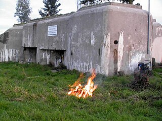
The Fort de Pré-Giroud, also known as the Fort de Vallorbe, is a 20th-century Swiss fortification located in the Jura Mountains near the Swiss border with France. The fort defended the Col de Jougne at Vallorbe, one of the few points in the Jura that could be easily traversable by an invading force. It was a component of the Swiss Border Line of defenses. Built between 1937 and 1939, the fort covers the Swiss end on the Mont d'Or railroad tunnel and the Joux valley. It is armed with three artillery blocks for 75mm guns and two machine gun blocks. All are camouflaged, the artillery blocks as rock formations, and the machine gun blocks as houses. Deactivated as a military post in the 1980s, it is operated as a museum.

Fort Reuenthal is a 20th-century Swiss fortification located in the Aargau canton near the Swiss border with Germany. Built between 1937 and 1939, the fort overlooks the Rhine where it bends around the town of Full-Reuenthal, and was intended to prevent a crossing of the Rhine at the hydroelectric plant at Dogern. It was a component of the Swiss Border Line of defenses. It is armed with two artillery blocks for 75 mm guns and two machine gun blocks. The fort uses camouflage, with house-like superstructures over some positions. Deactivated as a military post in 1988, it is operated as a museum.

Fort Ebersberg, also known as Fort Rüdlingen, was built between 1938 and 1940 in the Swiss Canton of Zurich to guard the Rhine against a German invasion at the opening of World War II. It is the only such position in the Zurich canton, located near the town of Berg am Irchel. The fort was part of the Swiss Border Line defenses, Swiss military designation A5438.
Fort Heldsberg was built 1938–1940 near St. Margrethen in Switzerland, overlooking the Rhine, which forms the Swiss-Austrian border at that location, just south of Lake Constance. The fort was part of the Swiss Border Line defenses, built between 1938 and 1941.
The Fortified Sector of Altkirch was the French military organization that in 1940 controlled the section of the French frontier with Germany and Switzerland in the vicinity of Basel. The sector's principal defense against an advance from Germany was the Rhine itself, which could be crossed only by boat or by seizing a bridge crossing. The frontier with Switzerland was not regarded as a high-risk location, save for a possible advance by German forces through Switzerland. Originally planned as a full extension of the Maginot Line with artillery ouvrages, the sector's fortifications were scaled back and chiefly took the form of casemates and blockhouses. The SF Altkirch adjoined the Fortified Sector of Mulhouse to the north and the Fortified Sector of Montbéliard to the west.
The Defensive Sector of the Rhône was the French military organization that in 1940 controlled the section of the French border with Switzerland and Italy in the area of Geneva. The area was not regarded as a likely point of invasion, owing to the neutrality of Switzerland and the extremely difficult terrain along the Italian portion of the border. It was therefore lightly fortified. Its chief fortified position was the 19th-century Fort l'Écluse, manned by a small force, which held its strategic position against a Panzerkorps for a week in June 1940.
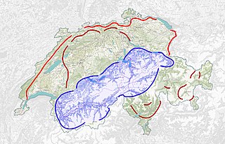
The Swiss National Redoubt is a defensive plan developed by the Swiss government beginning in the 1880s to respond to foreign invasion. In the opening years of the Second World War the plan was expanded and refined to deal with a potential German invasion. The term "National Redoubt" primarily refers to the fortifications begun in the 1880s that secured the mountainous central part of Switzerland, providing a defended refuge for a retreating Swiss Army.

Fort Saumarez is a Martello tower in Saint Peter, Guernsey, on a headland that forms the northern tip of L'Erée and extends to the Lihou causeway.
The France–Switzerland border is 572 km (355 mi) long. Its current path is mostly the product of the Congress of Vienna of 1815, with the accession of Geneva, Neuchâtel and Valais to the Swiss Confederation, but it has since been modified in detail, the last time being in 2002. Although most of the border, marked with border stones, is unguarded, several checkpoints remain staffed, most notably on busy roads.

The Swiss Military Museum is located at Full-Reuenthal in the Canton of Aargau.


