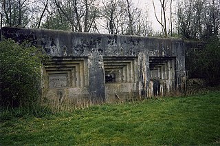
Fort Eben-Emael is an inactive Belgian fortress located between Liège and Maastricht, on the Belgian-Dutch border, near the Albert Canal, outside the village of Ében-Émael. It was designed to defend Belgium from a German attack across the narrow belt of Dutch territory in the region. Constructed in 1931–1935, it was reputed to be impregnable and at the time, the largest in the world.
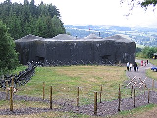
Czechoslovakia built a system of border fortifications as well as some fortified defensive lines inland, from 1935 to 1938 as a defensive countermeasure against the rising threat of Nazi Germany. The objective of the fortifications was to prevent the taking of key areas by an enemy—not only Germany but also Hungary and Poland—by means of a sudden attack before the mobilization of the Czechoslovak Army could be completed, and to enable effective defense until allies—Britain and France, and possibly the Soviet Union—could help.

Ouvrage Rochonvillers is one of the largest of the Maginot Line fortifications. Located above the town of Rochonvillers in the French region of Lorraine, the gros ouvrage or large work was fully equipped and occupied in 1935 as part of the Fortified Sector of Thionville in the Moselle. It is located between the petit ouvrage d'Aumetz and the gros ouvrage Molvange, facing the border between Luxembourg and France with nine combat blocks. Rochonvillers saw little action during World War II, but due to its size it was repaired and retained in service after the war. During the Cold War it found a new use as a hardened military command centre, first for NATO and then for the French Army.

The Alpine Wall was an Italian system of fortifications along the 1,851 km (1,150 mi) of Italy's northern frontier. Built in the years leading up to World War II at the direction of Italian dictator Benito Mussolini, the defensive line faced France, Switzerland, Austria, and Yugoslavia. It was defended by the "Guardia alla Frontiera" (GaF), Italian special troops.

The fortified region of Belfort formed the first line of defense in the Séré de Rivières system of fortifications in the Belfort Gap. Located in northeastern France between Épinal and Besançon, the primary line was built in the late 19th century to deal with advances in artillery that had made older defensive systems obsolete.

The Fort de Maulde, also known as Fort de Beurnonville and the Ensemble de Maulde, is located to the south of Maulde, France. It is part of the Fortified Sector of the Escaut, an extension of the Maginot Line. The Séré de Rivières system fort was built 1881–1884. In 1936–1937 the old fort, commanding high ground behind Maulde, was altered for more modern fortifications. It was evacuated by its garrison in 1940 during the Battle of France as part of the French retreat from the border with Belgium.

The Fort of Battice is a Belgian fortification located just to the east of the town of Battice. The fort was built in the 1930s as part of the fortified position of Liège, augmenting the twelve original forts built to defend Liège in the 1880s with four more forts closer to the Belgian frontier with Germany. Battice is nearly as large as the more famous Fort Eben-Emael. Work began in April 1934, with some finish work continuing in 1940 when war broke out. Following the successful German surprise attack on Eben-Emael, Battice held out against the Germans until 22 May 1940. On 28 May 1940 all Belgian forces surrendered. Battice has been preserved and may be visited by the public.
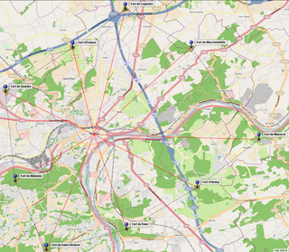
The fortified position of Namur was established by Belgium after the First World War to fortify the traditional invasion corridor between Germany and France through Belgium. The position incorporated the fortress ring of Namur, originally designed by the Belgian General Henri Alexis Brialmont to deter an invasion of Belgium by France. The old fortifications consisted of nine forts built between 1888 and 1892 on either side of the Meuse, around Namur.


The Fort de Pré-Giroud, also known as the Fort de Vallorbe, is a 20th-century Swiss fortification located in the Jura Mountains near the Swiss border with France. The fort defended the Col de Jougne at Vallorbe, one of the few points in the Jura that could be easily traversable by an invading force. It was a component of the Swiss Border Line of defenses. Built between 1937 and 1939, the fort covers the Swiss end on the Mont d'Or railroad tunnel and the Joux valley. It is armed with three artillery blocks for 75mm guns and two machine gun blocks. All are camouflaged, the artillery blocks as rock formations, and the machine gun blocks as houses. Deactivated as a military post in the 1980s, it is operated as a museum.
The Fort de Plainbois is a twentieth-century Swiss fortification located at the east end of the Jura Mountains near the Swiss border with France. It was a component of the Swiss Border Line of defenses. Built between 1937 and 1939, it was armed with two artillery blocks for 75mm guns and additional machine gun blocks. All are camouflaged. Deactivated as a military post in the 1990s, it has been offered for sale by the Swiss Defense Forces.

Fort Ebersberg, also known as Fort Rüdlingen, was built between 1938 and 1940 in the Swiss Canton of Zurich to guard the Rhine against a German invasion at the opening of World War II. It is the only such position in the Zurich canton, located near the town of Berg am Irchel. The fort was part of the Swiss Border Line defenses, Swiss military designation A5438.
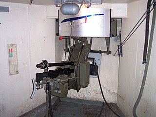
Fort Heldsberg was built 1938–1940 near St. Margrethen in Switzerland, overlooking the Rhine, which forms the Swiss-Austrian border at that location, just south of Lake Constance. The fort was part of the Swiss Border Line defenses, built between 1938 and 1941.

The Border Line defenses of Switzerland were constructed in the late 1930s in response to increasing tensions between Switzerland and its neighbours, chiefly the Axis powers of Germany and Italy. The Border Line was planned to slow or hold an invading force at the border. It consisted of a series of bunkers spaced at short intervals along the French, German and Austrian borders. The bunkers were reinforced by larger multi-blockhouse forts at key points. Most of the positions were within two or three kilometres of the frontier.
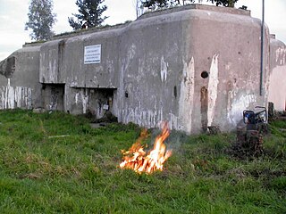
The Fortified Sector of Altkirch was the French military organization that in 1940 controlled the section of the French frontier with Germany and Switzerland in the vicinity of Basel. The sector's principal defense against an advance from Germany was the Rhine itself, which could be crossed only by boat or by seizing a bridge crossing. The frontier with Switzerland was not regarded as a high-risk location, save for a possible advance by German forces through Switzerland. Originally planned as a full extension of the Maginot Line with artillery ouvrages, the sector's fortifications were scaled back and chiefly took the form of casemates and blockhouses. The SF Altkirch adjoined the Fortified Sector of Mulhouse to the north and the Fortified Sector of Montbéliard to the west.
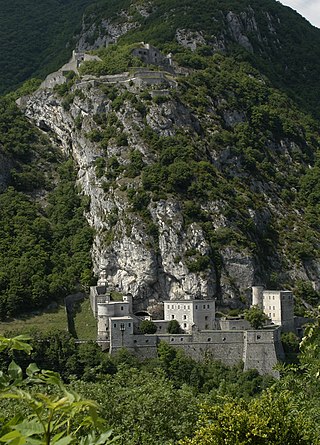
The Defensive Sector of the Rhône was the French military organization that in 1940 controlled the section of the French border with Switzerland and Italy in the area of Geneva. The area was not regarded as a likely point of invasion, owing to the neutrality of Switzerland and the extremely difficult terrain along the Italian portion of the border. It was therefore lightly fortified. Its chief fortified position was the 19th-century Fort l'Écluse, manned by a small force, which held its strategic position against a Panzerkorps for a week in June 1940.
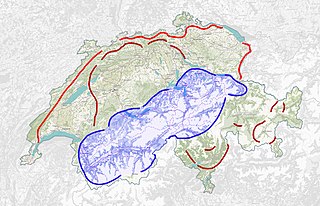
The Swiss National Redoubt is a defensive plan developed by the Swiss government beginning in the 1880s to respond to foreign invasion. In the opening years of the Second World War the plan was expanded and refined to deal with a potential German invasion. The term "National Redoubt" primarily refers to the fortifications begun in the 1880s that secured the mountainous central part of Switzerland, providing a defended refuge for a retreating Swiss Army.

The Swiss Military Museum is located at Full-Reuenthal in the Canton of Aargau.


