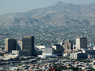
El Paso County is the westernmost county in the U.S. state of Texas. As of the 2010 census, the population was 800,647, making it the sixth-most populous county in the state of Texas. Its seat is the city of El Paso, the sixth-most populous city in Texas and the 22nd-most populous city in the United States. The county was created in 1850 and later organized in 1871.

El Paso is a city and the county seat of El Paso County, Texas, United States, in the far western part of the state. The 2018 population estimate for the city from the U.S. Census was 682,669, making it the 22nd largest city in the United States. Its metropolitan statistical area (MSA) covers all of El Paso and Hudspeth counties in Texas, and has a population of 840,758.
State Road 408, officially named the Spessard L. Holland East–West Expressway, is a tolled expressway running east–west through Orlando, Florida, United States. It is owned and operated by the Central Florida Expressway Authority (CFX), except for the westernmost mile (1.5 km), which is owned by Florida's Turnpike Enterprise as a connection to Florida's Turnpike. The road runs from the Turnpike in Gotha, east through downtown Orlando, where it intersects with Interstate 4, ending near State Road 50 south of the University of Central Florida. The road is named for Spessard L. Holland.
Illinois Route 390 (IL 390), previously known as the Elgin–O'Hare Expressway, now known as the Elgin–O'Hare Tollway, is a 9.8-mile-long (15.8 km) electronic toll highway in northeastern Illinois. IL 390 currently connects U.S. Route 20 in Hanover Park to the intersection with Illinois Route 83 and Thorndale Avenue in Wood Dale. The only other towns it borders are Schaumburg and Roselle. Construction is underway to extend the road from IL 83 to the western edge of O'Hare International Airport.
Interstate 110 (I-110) is a 0.9-mile (1.4 km) Interstate spur route in El Paso extending from Interstate 10 (I-10), south along U.S. Highway 54, turns west then turns south into Mexico. I-110 provides access from I-10 to the Bridge of the Americas, which spans the Rio Grande to connect with Avenida Abraham Lincoln in Ciudad Juárez, Mexico. I-110 is currently the only three-digit Interstate to connect directly with Mexico, and one of only two to connect to an international border, the other being Interstate 190 in New York.
Interstate 540 (I-540) and North Carolina Highway 540 (NC 540) are part of a partially completed beltway around the city of Raleigh in the U.S. state of North Carolina forming the Raleigh Outer Loop. When complete, the route will completely encircle the city, meeting its parent route of Interstate 40 in one location.

The President George Bush Turnpike (PGBT) is a 52-mile (84 km) toll road running through the northern, northeastern and western suburbs, forming a partial loop around Dallas, Texas, United States. It is named for the late George H. W. Bush, the 41st President of the United States. At its west end near Belt Line Road in Irving, State Highway 161 continues southwest to Interstate 20 (I-20) in Grand Prairie. The discontinuous free frontage roads along the turnpike from I-35E in Carrollton east to its end at I-30 in Garland are assigned the State Highway 190 designation. SH 190 signage appears only along the Rowlett, Garland, Richardson, Plano, and Carrollton sections of the frontage road with the undersign "frontage road only". At intersections with city streets, only the Bush Turnpike signs are displayed, not the SH 190 signage. Prior to the construction of the main lanes as a tollway, SH 190 was used as the name of the planned main lanes too. Similarly, the part west of I-35E was planned as part of SH 161. Bush Turnpike is signed as a north–south road from I-20 to I-35E, an east–west road from I-35E to the Merritt Main Lane Gantry and as a north–south road from the Merritt Main Lane Gantry to I-30, as Bush Turnpike makes a nearly 90-degree curve in both places.
The Dolphin Expressway is a 15-mile-long (24 km), six-lane, divided controlled-access highway, with the westernmost 14 miles (23 km) as an all electronic tollway signed as State Road 836, and the easternmost 1.292 miles (2.079 km) between Interstate 95 (I-95) and SR A1A cosigned as Interstate 395. The road currently extends from just north of the intersection of Southwest 137th Avenue and U.S. Highway 41 (US 41) in Tamiami, eastward past the Homestead Extension of Florida's Turnpike and Miami International Airport, before intersecting I-95, becoming I-395 and ending at SR A1A in Miami at the west end of the MacArthur Causeway. The Dolphin Expressway is maintained and operated by the Miami-Dade Expressway Authority (MDX), while the I-395 section is maintained by the Florida Department of Transportation (FDOT). The Dolphin Expressway from the Palmetto Expressway to I-95 opened in 1969, with the I-395 section opening in 1971, the extension to the HEFT opening in 1974 and a second western extension opening in 2007.
State Highway 45 is a highway loop around Austin, Texas, that exists in two open segments. The official designation of SH 45 is such to form a complete loop around Austin, a distance of roughly 80 miles (130 km).
Loop 375 is a beltway that partially encircles the city of El Paso, Texas. The beltway is mostly a freeway, except for its northern section, which includes at-grade intersections. The highway passes through various areas of El Paso, funneling traffic within and around the city. The road is known locally under different names, as Woodrow Bean Transmountain Drive in the northern section, Purple Heart Memorial Freeway in the northeastern section, Joe Battle Boulevard in the eastern section, the César Chávez Border Highway in the southern section, and the Border West Expressway on the southwest section.
Loop 49 is a tollway that, along with I-20, will encircle the city of Tyler, Texas upon its completion. Routing of the loop north of I-20 bypasses Lindale to the west and passes by the west and south sides of Tyler south of I-20. The highway interconnects suburban areas and areas of potential development around Tyler with I-20 and provides local areas easier access to the Dallas–Fort Worth metroplex.
Interstate 10 (I-10) is the major east–west Interstate Highway in the Southern United States. In the U.S. state of Texas, it runs east from Anthony, at the border with New Mexico, through El Paso, San Antonio and Houston to the border with Louisiana in Orange, Texas. At just under 880 miles (1,420 km), the Texas segment of I-10, maintained by the Texas Department of Transportation, is the longest continuous untolled freeway in North America that is operated by a single authority. It is also the longest stretch of highway with a single designation within a single state. Mile marker 880 and its corresponding exit number in Orange, Texas, are the highest numbered mile marker and exit on any freeway in North America. After widening was completed in 2008, a portion of the highway west of Houston is now also believed to be the widest in the world, at 26 lanes. There is a wider section in China on the G4 Beijing–Hong Kong–Macau Expressway; however, that section is a toll plaza approach.
Interstate 90 (I-90) in the U.S. state of Illinois runs roughly northwest-to-southeast through the northern part of the state. From the Wisconsin state line at South Beloit, it heads south to Rockford before heading east-southeast to the Indiana state line at Chicago. I-90 traverses 108 miles (174 km) through a variety of settings, from farmland west of the Fox River Valley through the medium-density suburbs west of O'Hare International Airport, through downtown Chicago, and through the heart of the industrial southeast side of Chicago before entering Indiana.

U.S. Route 54 in Texas is a U.S. Highway that travels through two portions of the state: one in the far western point, and the other in the far northwest Panhandle.
U.S. Highway 85 or US 85 is a route in the system of United States Numbered Highways maintained by the Texas Department of Transportation (TxDOT). The Texas portion of US 85 is located entirely within El Paso County beginning at the U.S.-Mexico border between the city of El Paso and Ciudad Juárez, Chihuahua. The approximately 20-mile (32 km) route briefly overlays US 62 in downtown El Paso, then traverses north along the city's west side before merging with the combined route of Interstate 10 and US 180. The route then follows I-10 and US 180 through the towns of Vinton and Anthony before crossing the New Mexico state line into the town of Anthony, New Mexico, in Doña Ana County.

The Bridge of the Americas (BOTA) is a group of international bridges which cross the Rio Grande and Texas State Highway Loop 375, connecting the Mexico–United States border cities of Ciudad Juárez, Chihuahua and El Paso, Texas, via the MX 45 from the south and the I-110 from the north, crossing the El Paso BOTA Port of Entry. The bridge is colloquially known as "Puente Libre" in Ciudad Juárez, officially as "Puente Internacional Córdova-Las Américas" or "Puente Internacional Córdova de las Américas", and also known as "Puente Río Bravo", "Cordova Bridge" and "Free Bridge".
The Triangle Expressway (TriEx) is the first modern toll road built in North Carolina, and one of the first toll roads in the United States built to use only electronic toll collection instead of toll booths. The overall freeway consists of two segments called the Triangle Parkway and the Western Wake Freeway. The six-lane Triangle Parkway extends the pre-existing NC 147 3.5 miles (5.6 km) in Durham County to meet NC 540 in Morrisville in Wake County. The Western Wake Freeway extends the total Triangle Expressway to 18.8 miles (30.3 km) long, extending NC 540 where it continues along to Holly Springs.

El Paso–Juárez, also known as Juárez–El Paso, the Borderplex or Paso del Norte, is a binational metropolitan area, or conurbation, on the border between Mexico and the United States. The region is centered on two large cities: Ciudad Juárez, Chihuahua, Mexico and El Paso, Texas, U.S. Additionally, nearby Las Cruces, New Mexico, U.S. is sometimes included as part of the region, referred to as El Paso–Juárez–Las Cruces or El Paso–Juárez–Southern New Mexico. With over 2.7 million people, this binational region is the 2nd largest metropolitan area on the United States–Mexico border. The El Paso–Juárez region is the largest bilingual, binational work force in the Western Hemisphere.
Texas State Highway Spur 601 or Spur 601 is a 7.4-mile-long (11.9 km) freeway spur route in El Paso County in the U.S. State of Texas. It runs from U.S. Route 54 in El Paso eastward to Loop 375 in the Fort Bliss Military Reservation. The construction of this freeway improved access to Biggs Army Airfield and Fort Bliss. The route is officially known as the Liberty Expressway.
The El Paso Streetcar is a streetcar system in El Paso, Texas, that opened for service on November 9, 2018, and uses a fleet of restored PCC streetcars that had served the city's previous system until its closure in 1974. The system covers 4.8 miles (7.7 km) in two loops from Downtown El Paso to University of Texas at El Paso. The system was constructed under the authority of the Camino Real Regional Mobility Authority, but when the major construction was completed, around spring 2018, it was transferred to Sun Metro, for operation and maintenance. As of 2016, construction of the system was projected to cost $97 million.


