
The Berlin Wall was a guarded concrete barrier that encircled West Berlin of the Federal Republic of Germany (FRG) from 1961 to 1989, separating it from East Berlin and the German Democratic Republic (GDR). Construction of the Berlin Wall was commenced by the government of the GDR on 13 August 1961. It included guard towers placed along large concrete walls, accompanied by a wide area that contained anti-vehicle trenches, beds of nails and other defenses. The primary intention for the Wall's construction was to prevent East German citizens from fleeing to the West.

Göttingen is a district in Lower Saxony, Germany. It is bounded by the districts of Northeim and Goslar, and by the states of Thuringia and Hesse. The capital is the university city of Göttingen.

Duderstadt is a city in southern Lower Saxony, Germany, located in the district of Göttingen.

The inner German border was the frontier between the German Democratic Republic and the Federal Republic of Germany from 1949 to 1990. De jure not including the similar but physically separate Berlin Wall, the border was 1,381 kilometres (858 mi) long and ran from the Baltic Sea to Czechoslovakia.

Leinefelde-Worbis is a town in the district of Eichsfeld, in northwestern Thuringia, Germany. The town was formed on March 16, 2004, from the former independent towns Leinefelde and Worbis along with the municipalities of Breitenbach and Wintzingerode. In July 2018 the former municipality of Hundeshagen, and in January 2019 Kallmerode was merged into Leinefelde-Worbis. The population before the amalgamation was 14,387 for Leinefelde, 5,541 for Worbis, 1,021 for Breitenbach and 614 for Wintzingerode. The 10 parts of Leinefelde-Worbis are Leinefelde, Worbis, Breitenbach, Kirchohmfeld, Birkungen, Beuren, Hundeshagen, Kaltohmfeld, Wintzingrode, Kallmerode and Breitenholz.

Dingelstädt is a town in the district of Eichsfeld in Thuringia, Germany. It is situated on the upper course of the river Unstrut, 8 km (5 mi) south of Leinefelde-Worbis and 15 km (9 mi) northwest of Mühlhausen. The former municipalities Helmsdorf, Kefferhausen, Kreuzebra and Silberhausen were merged into Dingelstädt in January 2019. In January 2023 Dingelstädt absorbed the villages Bickenriede and Zella from the former municipality Anrode, and Beberstedt and Hüpstedt from the former municipality Dünwald.

Teistungen is a municipality in the district of Eichsfeld in Thuringia, Germany.

The Eichsfeld is a historical region in the southeast of the state of Lower Saxony and northwest of the state of Thuringia in the south of the Harz mountains in Germany. Until 1803 the Eichsfeld was for centuries part of the Archbishopric of Mainz, which is the cause of its current position as a Catholic enclave in the predominantly Protestant north of Germany. Following German partition in 1945, the West German portion became Landkreis Duderstadt. A few small transfers of territory between the American and Soviet zones of occupation took place in accordance with the Wanfried Agreement.

The Berlin border crossings were border crossings created as a result of the post-World War II division of Germany. Prior to the construction of the Berlin Wall in 1961, travel between the Eastern and Western sectors of Berlin was completely uncontrolled, although restrictions were increasingly introduced by the Soviet and East German authorities at major crossings between the sectors. This free access, especially after the closure of the Inner German border, allowed the Eastern Bloc emigration and defection to occur. East German officials, humiliated by this mass defection, subsequently chose to erect the Berlin Wall in order to prevent residents from leaving East Germany.

The German Green Belt is a project of Bund Naturschutz (BUND), one of Germany's largest environmental groups. The project began in 1989 facing the 870-mile (1,400 km) network of inner-German border fences and guard towers formerly separating East and West Germany. It is one of the world's most unusual nature reserves, lying along the old "Death Strip," turning a monument to repression into a symbol of renewal.

Observation Post Alpha, OP Alpha, or Point Alpha was a Cold War observation post between Rasdorf, Hesse, in what was then West Germany and Geisa, Thuringia, then part of East Germany. The post overlooked part of the "Fulda Gap", which would have been a prime invasion route for Warsaw Pact forces had the Cold War erupted into actual warfare. It was abandoned by the military in 1991. Today, the "Point Alpha" memorial commemorates the observation point's four decades of existence. The memorial is dedicated to keeping it and a nearby section of the inner German border as reminders of the division of Germany and the confrontation between NATO and Warsaw Pact in the Cold War.
The Helmstedt–Marienborn border crossing, named Grenzübergangsstelle Marienborn (GÜSt) by the German Democratic Republic (GDR), was the largest and most important border crossing on the Inner German border during the division of Germany. Due to its geographical location, allowing for the shortest land route between West Germany and West Berlin, most transit traffic to and from West Berlin used the Helmstedt-Marienborn crossing. Most travel routes from West Germany to East Germany and Poland also used this crossing. The border crossing existed from 1945 to 1990 and was situated near the East German village of Marienborn at the edge of the Lappwald. The crossing interrupted the Bundesautobahn 2 (A 2) between the junctions Helmstedt-Ost and Ostingersleben.

The European Green Belt initiative is a grassroots movement for nature conservation and sustainable development along the corridor of the former Iron Curtain. The term refers to both an environmental initiative as well as the area it concerns. The initiative is carried out under the patronage of the International Union for Conservation of Nature and formerly Mikhail Gorbachev. It is the aim of the initiative to create the backbone of an ecological network that runs from the Barents to the Black and Adriatic Seas.
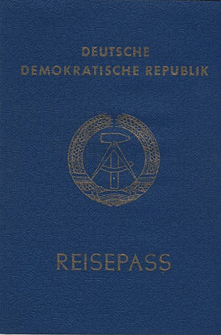
The East German passport was issued to citizens of the former German Democratic Republic for international travel. Since the reunification of Germany in October 1990, all German citizens have been issued German passports.

The Iron Curtain is a political metaphor used to describe the political boundary dividing Europe into two separate areas from the end of World War II in 1945 until the end of the Cold War in 1991. The term symbolizes the efforts by the Soviet Union (USSR) to block itself and its satellite states from open contact with the West, its allies and neutral states. On the east side of the Iron Curtain were the countries that were connected to or influenced by the Soviet Union, while on the west side were the countries that were NATO members, or connected to or influenced by the United States; or nominally neutral. Separate international economic and military alliances were developed on each side of the Iron Curtain. It later became a term for the 7,000-kilometre-long (4,300 mi) physical barrier of fences, walls, minefields, and watchtowers that divided the "east" and "west". The Berlin Wall was also part of this physical barrier.

The Tränenpalast is a former border crossing point between East and West Berlin, at Berlin Friedrichstraße station, which was in operation between 1962 and 1989. It is now a museum with exhibitions about Berlin during the Cold War period and about the process of German reunification. It was the border crossing for travellers on the S-bahn, U-bahn and trains going between East and West Germany. It was used only for westbound border crossings. It had separate checkpoints for West Berliners, West Germans, foreigners, diplomats, transit travellers and East Germans.

Crossing the inner German border remained possible throughout the Cold War; it was never entirely sealed in the fashion of the border between the two Koreas, though there were severe restrictions on the movement of East German citizens. The post-war agreements on the governance of Berlin specified that the Western Allies were to have access to the city via defined air, road, rail and river links. This was mostly respected by the Soviets and East Germans, albeit with periodic interruptions and harassment of travellers. The worst disruption to this was in 1948 during the Berlin Blockade when supplies could only be brought in by air – the famous Berlin Airlift – although Allied military convoys could pass through East Germany en route to Berlin.

Fall of inner German border, also known as Opening of inner German border, rapidly and unexpectedly occurred in November 1989, along with the fall of the Berlin Wall. The event paved the way for the ultimate reunification of Germany just short of a year later.

Böseckendorf is a village in the Teistungen municipality in the district of Eichsfeld in Germany. It became famous during the Cold War for two mass escapes in 1961 and 1963 involving a total of 65 inhabitants – a quarter of the village's population – across the heavily fortified inner German border.


