Borges–Clarksburg Airport

Last updated
Borges–Clarksburg Airport
Summary
Airport typePrivate
OwnerJoseph Borges
Serves Clarksburg, California
Elevation  AMSL 12 ft / 4 m
Coordinates 38°26′36″N121°30′32″W / 38.44333°N 121.50889°W / 38.44333; -121.50889
Runways
Direction LengthSurface
ftm
9/272,260689Turf
Statistics (2001)
Aircraft operations3,000
Based aircraft19

Borges–Clarksburg Airport( FAA LID : CN13, formerly C14) [2] is a private-use airport located two  nautical miles (4  km) northeast of the central business district of Clarksburg, in Yolo County, California, United States. [1]

Federal Aviation Administration United States Government agency dedicated to civil aviation matters

The Federal Aviation Administration (FAA) is a governmental body of the United States with powers to regulate all aspects of civil aviation in that nation as well as over its surrounding international waters. Its powers include the construction and operation of airports, air traffic management, the certification of personnel and aircraft, and the protection of U.S. assets during the launch or re-entry of commercial space vehicles. Powers over neighboring international waters were delegated to the FAA by authority of the International Civil Aviation Organization.

A location identifier is a symbolic representation for the name and the location of an airport, navigation aid, or weather station, and is used for manned air traffic control facilities in air traffic control, telecommunications, computer programming, weather reports, and related services.

Airport location where aircraft take off and land

An airport is an aerodrome with extended facilities, mostly for commercial air transport. Airports often have facilities to store and maintain aircraft, and a control tower. An airport consists of a landing area, which comprises an aerially accessible open space including at least one operationally active surface such as a runway for a plane to take off or a helipad, and often includes adjacent utility buildings such as control towers, hangars and terminals. Larger airports may have airport aprons, taxiway bridges, air traffic control centres, passenger facilities such as restaurants and lounges, and emergency services. In some countries, the US in particular, they also typically have one or more fixed-base operators, serving general aviation.

Contents

The airport was established in 1945 and received a permit from the California Department of Transportation, Division of Aeronautics in 1949.

California Department of Transportation government agency

The California Department of Transportation (Caltrans) is an executive department of the US state of California. The department is part of the cabinet-level California State Transportation Agency (CalSTA). Caltrans is headquartered in Sacramento.

Facilities and aircraft

Borges–Clarksburg Airport covers an area of 18 acres (7 ha) at an elevation of 12 feet (4 m) above mean sea level. It has one runway designated 9/27 with a turf surface measuring 2,260 by 90 feet (689 x 27 m). [1]

Acre unit of area

The acre is a unit of land area used in the imperial and US customary systems. It is traditionally defined as the area of one chain by one furlong, which is exactly equal to 10 square chains, ​1640 of a square mile, or 43,560 square feet, and approximately 4,047 m2, or about 40% of a hectare. Based upon the International yard and pound agreement of 1959, an acre may be declared as exactly 4,046.8564224 square metres. The acre is a statute measure in the United States and was formerly one in the United Kingdom and almost all countries of the former British Empire, although informal use continues.

Hectare metric unit of area

The hectare is an SI accepted metric system unit of area equal to a square with 100-metre sides, or 10,000 m2, and is primarily used in the measurement of land. There are 100 hectares in one square kilometre. An acre is about 0.405 hectare and one hectare contains about 2.47 acres.

Elevation Height of a geographic location above a fixed reference point

The elevation of a geographic location is its height above or below a fixed reference point, most commonly a reference geoid, a mathematical model of the Earth's sea level as an equipotential gravitational surface . The term elevation is mainly used when referring to points on the Earth's surface, while altitude or geopotential height is used for points above the surface, such as an aircraft in flight or a spacecraft in orbit, and depth is used for points below the surface.

For the 12-month period ending December 31, 2001, the airport had 3,000 general aviation aircraft operations, an average of 250 per month. At that time there were 19 aircraft based at this airport: 95% single-engine, and 5% ultralight. [1]

General aviation civil use of aircraft excluding commercial transportation

General aviation (GA) is all civil aviation operations other than scheduled air services and non-scheduled air transport operations for remuneration or hire. General aviation flights range from gliders and powered parachutes to rotorcraft and corporate business jets. The majority of the world's air traffic falls into this category, and most of the world's airports serve general aviation exclusively.

Aircraft engine Engine designed for use in powered aircraft

An aircraft engine is a component of the propulsion system for an aircraft that generates mechanical power. Aircraft engines are almost always either lightweight piston engines or gas turbines, except for small multicopter UAVs which are almost always electric aircraft.

Related Research Articles

King Salmon Airport airport

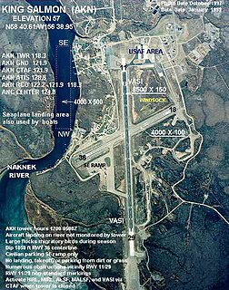
King Salmon Airport is a state owned, public use airport located just southeast of King Salmon, in the Bristol Bay Borough of the U.S. state of Alaska. It was formerly the Naknek Air Force Base, named for its location near the Naknek River.

Anniston Regional Airport

Anniston Regional Airport, formerly known as Anniston Metropolitan Airport, is a city-owned public-use airport located five nautical miles southwest of the central business district of Anniston, a city in Calhoun County, Alabama, United States. It is included in the National Plan of Integrated Airport Systems for 2011–2015, which categorized it as a general aviation airport.

Rostraver Airport

Rostraver Airport is a public use airport in Westmoreland County, Pennsylvania, United States. It is located five nautical miles east of the central business district of Monongahela, Pennsylvania in Rostraver Township. It is operated by the Westmoreland County Airport Authority, which also operates the Arnold Palmer Regional Airport in Unity Township, Pennsylvania.

Danielson Airport

Danielson Airport is a state owned, public use airport located two nautical miles (4 km) northwest of the central business district of Danielson, a borough in the town of Killingly in Windham County, Connecticut, United States. The smallest airport in the state, it is included in the Federal Aviation Administration (FAA) National Plan of Integrated Airport Systems for 2017–2021, in which it is categorized as a local general aviation facility.

Talladega Municipal Airport

Talladega Municipal Airport is a city-owned public-use airport located eight nautical miles northeast of the central business district of Talladega, a city in Talladega County, Alabama, adjacent to Talladega Superspeedway in the city of Lincoln. It is included in the FAA's National Plan of Integrated Airport Systems for 2011–2015, which categorized it as a general aviation facility.

Joseph State Airport airport

Joseph State Airport is a public use airport located one nautical mile west of the central business district of Joseph, a city in Wallowa County, Oregon, United States. It is owned by the Oregon Department of Aviation.

Vernonia Municipal Airport

Vernonia Municipal Airport is a city-owned, public-use airport located two nautical miles west of the central business district of Vernonia, a city in Columbia County, Oregon, United States.

Monticello Municipal Airport (Arkansas)

Monticello Municipal Airport, also known as Ellis Field, is a public-use airport located two nautical miles east of the central business district of Monticello, in Drew County, Arkansas, United States. It is owned by the City of Monticello.

Oakland Southwest Airport

Oakland Southwest Airport is a county-owned public-use airport in Oakland County, Michigan, United States. It is located one nautical mile (1.85 km) southwest of the central business district of New Hudson. The airport is uncontrolled, and is used for general aviation purposes.

Jeremiah Denton Airport

Jeremiah Denton Airport, formerly Dauphin Island Airport, is a county-owned public-use airport in Mobile County, Alabama, United States. It is just northwest of the central business district of Dauphin Island, a town located on a barrier island. The airport is on Mobile Bay, west of the Aloe Bay Channel.

Carl Folsom Airport

Carl Folsom Airport is a public-use airport located two nautical miles west of the central business district of Elba, a city in Coffee County, Alabama, United States. It is owned by the Elba Airport Authority.

North Omaha Airport

North Omaha Airport is a privately owned, public-use airport located seven nautical miles northwest of the central business district of Omaha, a city in Douglas County, Nebraska, United States.

Lake Cumberland Regional Airport is a public use airport located three nautical miles (6 km) south of the central business district of Somerset, a city in Pulaski County, Kentucky, United States. The airport is owned by the city of Somerset and Pulaski County. It also serves the area around Lake Cumberland. It is mostly used for general aviation, and from late 2008 until February 2010, was served by one commercial airline, Locair. The $3 million federally funded passenger terminal was converted to the FBO in September 2011.

Grant Airport is a privately owned, public use airport located two nautical miles (4 km) northeast of the central business district of Grant, a city in Newaygo County, Michigan, United States. The airport in uncontrolled, and is used for general aviation purposes.

Ocotillo Airport is a county-owned, public-use airport located in Ocotillo Wells, an unincorporated community in San Diego County, California, United States.

Ranchaero Airport

Ranchaero Airport is a private-use airport a mile west of Chico, in Butte County, California.

Paradise Skypark

Paradise Skypark is a private use airport located three nautical miles (6 km) south of the central business district of Paradise, in Butte County, California, United States.

Choteau Airport is a public use airport located one nautical mile (2 km) northeast of the central business district of Choteau, a city in Teton County, Montana, United States. The airport is owned by the city and county. It is included in the National Plan of Integrated Airport Systems for 2011–2015, which categorized it as a general aviation airport.

Mission Field is a public use airport located five nautical miles east of the central business district of Livingston, a city in Park County, Montana, United States. It is owned by the city and county. This airport is included in the National Plan of Integrated Airport Systems for 2011–2015, which categorized it as a general aviation facility.

Winterset Municipal Airport

Winterset Municipal Airport is a public use airport located two nautical miles (4 km) north of the central business district of Winterset, a city in Madison County, Iowa, United States. Formerly known as Winterset-Madison County Airport, it is owned by the Winterset Airport Authority. This airport is included in the National Plan of Integrated Airport Systems for 2011–2015, which categorized it as a general aviation facility.

References