Geography
The Bos originates at the Zallenberg at an elevation of 490 metres (1,610 ft) above sea level. From here, the stream flows predominantly to the east. It passes the village of Bosen, part of Nohfelden, on the north and then, after about 3.4 kilometres (2.1 mi), it reaches the Bostalsee. Just before the reservoir it is joined by the right tributary Pärwiesbach which reaches it after flowing through Bosen. Its mouth is located about 300 metres (980 ft) south of the village of Eckelhausen, also part of Nohfelden. The outlet of the Bostalsee is located southwest of Gonnesweiler. South of the Bostalsee the Dämelbach flows into the Bos. After only about a further 1 kilometre (3,300 ft) the Bos joins the Nahe on the left at an elevation of 379 metres (1,243 ft) above sea level.
On its 5.8-kilometre-long (3.6 mi) course, the Bos drops 111 metres (364 ft), which corresponds to a mean bottom slope of 1.91%. It drains a 12,634 square kilometres (4,878 sq mi) drainage basin.

The Saône is a river in eastern France. It is a right tributary of the Rhône, rising at Vioménil in the Vosges department and joining the Rhône in Lyon, at the southern end of the Presqu'île.

The Kura is an east-flowing river south of the Greater Caucasus Mountains which drains the southern slopes of the Greater Caucasus east into the Caspian Sea. It also drains the north side of the Lesser Caucasus, while its main tributary, the Aras, drains the south side of those mountains. Starting in northeastern Turkey, the Kura flows through Turkey to Georgia, then to Azerbaijan, where it receives the Aras as a right tributary, and enters the Caspian Sea at Neftçala. The total length of the river is 1,515 kilometres (941 mi).

The Nizhnyaya Tunguska is a river in Siberia, Russia, that flows through the Irkutsk Oblast and the Krasnoyarsk Krai. The river is a right tributary of the Yenisey joining it at Turukhansk. The ice-free period on the Nizhnyaya Tunguska starts in mid-June and ends in the first half of October. The river forms the western limit of the Lena Plateau.

Ahr is a river in Germany, a left tributary of the Rhine. Its source is at an elevation of approximately 470 metres (1,540 ft) above sea level in Blankenheim in the Eifel, in the cellar of a timber-frame house near the castle of Blankenheim. After 18 kilometres (11 mi) it crosses from North Rhine-Westphalia into Rhineland-Palatinate.

The Chusovaya is a river flowing in Perm Krai, Sverdlovsk Oblast and Chelyabinsk Oblast of Russia. A tributary of the Kama, which in turn is a tributary of the Volga, discharges into the Chusovskoy Cove of the Kamsky Reservoir. The river is remarkable in that it originates on the eastern slopes of the Ural Mountains in Asia, crosses the mountains, and mostly runs on their western slopes in Europe. The Chusovaya River is widely used as a source of water. In particular, its water is taken from the Volchikhinsky Reservoir, 37 square kilometres (14 sq mi), to the Verkhneisetsky Reservoir to supply the major city of Yekaterinburg. Fifteen smaller reservoirs are spread over about 150 tributaries of the river.

The Nahe is a river in Rhineland-Palatinate and Saarland, Germany, a left tributary to the Rhine. It has also given name to the wine region Nahe situated around it.

The Doubs is a 453-kilometre (281 mi) river in far eastern France which strays into western Switzerland. It is a left-bank tributary of the Saône. It rises near Mouthe in the western Jura mountains, at 946 metres (3,104 ft) and its mouth is at Verdun-sur-le-Doubs, a village and commune in Saône-et-Loire at about 175 m (574 ft) above sea level. It is the tenth-longest river in France.

The Ardèche is a 125-kilometre (78 mi) long river in south-central France, a right-bank tributary of the River Rhône. Its source is in the Massif Central, near the village of Astet. It flows into the Rhône near Pont-Saint-Esprit, north-west of Orange. The river gives its name to the French department of Ardèche.

Nohfelden is a municipality in the district of Sankt Wendel, in Saarland, Germany. It is situated approximately 15 kilometres (9.3 mi) north of Sankt Wendel, and 20 kilometres (12 mi) southwest of Idar-Oberstein. It was formed during administrative reform in January 1974 from the merger of 13 previously independent municipalities.

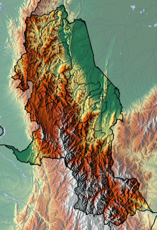
The department of Norte de Santander in northwestern Colombia, and its capital, Cúcuta, contains several rivers. The rivers are mostly part of the Maracaibo Lake basin, with the southeastern section located in the Magdalena River basin. Important fluvial elements are the Zulia, Catatumbo and Pamplonita Rivers. The entity in charge of taking care of these hydrology of Norte de Santander is Corponor.

Himachal Pradesh provides water to both the Indus and Ganges basins. The drainage systems of the region are the Chenab, the Ravi, the Beas, the Satluj and the Yamuna. These rivers are perennial and are fed by snow and rainfall. They are protected by an extensive cover of natural vegetation.

The Kargat is a river in Novosibirsk Oblast, Russia. It is a right tributary of the Chulym. The Kargat is 387 kilometres (240 mi) in length, with a drainage basin of 7,210 square kilometres (2,780 sq mi).

The Raidāk River, also called Wang Chhu or Wong Chhu in Bhutan, is a trans-boundary river originating in Bhutan that is a tributary of the River Brahmaputra. It flows through Bhutan, India and Bangladesh. It is one of the main rivers in Alipurduar District, West Bengal, India.

The Anuy is a left tributary of the Ob originating in the Altai Mountains of Siberia, Russia. It is 327 kilometres (203 mi) long, and has a drainage basin of 6,930 square kilometres (2,680 sq mi).

The Speyerbach is a left tributary of the Rhine in the Palatinate part of Rhineland-Palatinate. In Speyer, the river split into Gießhübelbach and Woogbach. The Woogbach changes its name to Nonnenbach, then flows into Gießhübelbach shortly before the latter flows into the Rhine.

Schlichem is a river of Baden-Württemberg, Germany. It passes through Schömberg and flows, 33 km (21 mi) away, into the Neckar in Epfendorf.

The Sissle is a 16-kilometre (10 mi) long river in the Swiss canton of Aargau in Switzerland. It is a tributary of the Rhine and drains the eastern part of the Fricktal. The largest town on the river is Frick.
The Azevka is a river the Agryzsky District of the Republic of Tatarstan, Russia. It is a left tributary of the Izh in the basin of the Kama.

The Bostalsee is a reservoir in the municipality of Nohfelden in the northern Saarland. It was created in 1979. The dam has a length of 500 metres. The lake is almost exclusively used for recreation. The hydropower from the stored water has been used since the end of 2013 to a small extent to generate electricity, especially to light the circular walk around the lake in winter. The southwestern part of the lake has been designated as a nature reserve.

The Aubach is an orographically left tributary of the River Wiehl in the German state of North Rhine-Westphalia.


