Sankt Wendel is a Kreis (district) in the north of the Saarland, Germany. Neighboring districts are Trier-Saarburg, Birkenfeld, Kusel, Neunkirchen, Saarlouis, and Merzig-Wadern.

The Santa Fe Dam Recreation Area is a county park located in Irwindale, California, US, in the San Gabriel Valley, inside the Santa Fe Dam. The park and dam are nestled among gravel quarries in the area, many of which are currently inactive. The dam is a flood-control dam on the San Gabriel River. The dam functions as a dry dam most of the time. The San Gabriels produce more gravel than most other mountains. The park is maintained and operated by the Los Angeles County Department of Parks and Recreation. The park, located off the San Gabriel River Freeway, contains a 70-acre lake for year-round fishing and non motorized watercraft.

The Eder is a 177-kilometre-long (110 mi) major river in Germany that begins in eastern North Rhine-Westphalia and passes in to Hesse, where it empties into the River Fulda.

The Sepulveda Dam is a dry dam constructed by the U.S. Army Corps of Engineers to withhold winter flood waters along the Los Angeles River. Completed in 1941, at a cost of $6,650,561, it is located south of center in the San Fernando Valley, approximately eight miles (13 km) east of the river's source in the western end of the Valley, in Los Angeles, California.
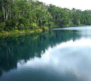
Lake Eacham is a popular lake of volcanic origin on the Atherton Tableland of Queensland, Australia, within the World Heritage listed Wet Tropics of Queensland. It is within the locality of Lake Eacham in the Tablelands Region local government area.

The Schluchsee is a reservoir lake in the district of Breisgau-Hochschwarzwald, southeast of the Titisee in the Black Forest near Freiburg im Breisgau, Germany.
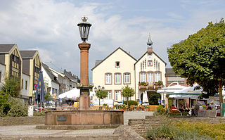
Wadern is a municipality in the federal state Saarland, which is situated in the southwest of Germany. It is part of the district Merzig-Wadern. Wadern consists of 13 urban districts with approximately 16.000 inhabitants. With 143 inhabitants per km2 it is sparsely populated, but, with an area of 111 km2, Wadern is the third largest municipality in Saarland after Saarbrücken and St. Wendel. The town is divided into 14 urban districts and altogether 24 villages belong to the commune. The town is part of the Moselle Franconian language area.

Three Rivers Park District is a special park district serving the suburban areas of the Twin Cities including suburban Hennepin, Carver, Dakota, Scott, and Ramsey counties. Three Rivers's mission is "To promote environmental stewardship through recreation and education in a natural resources-based park system." Three Rivers operates twenty parks and ten regional trails, with at least two more regional trails planned. Nearly seven million people visit Three Rivers facilities each year. It has over 27,000 acres (11,000 ha) of parks and trails.
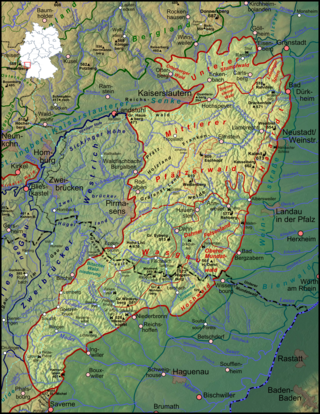
The Palatinate Forest, sometimes also called the Palatine Forest, is a low-mountain region in southwestern Germany, located in the Palatinate in the state of Rhineland-Palatinate. The forest is a designated nature park covering 1,771 km2 and its highest elevation is the Kalmit.

Namborn is a municipality in the district of Sankt Wendel, in Saarland, Germany. It is situated approximately 7 km north of Sankt Wendel, and 25 km southwest of Idar-Oberstein. It is approximately 40 km northeast of Saarbrücken on highway B 41 and the Nahe Valley Railway line. The distance to the Bostalsee is about 10 km, and to the county seat St. Wendel about 7 km.

Nohfelden is a municipality in the district of Sankt Wendel, in Saarland, Germany. It is situated approximately 15 kilometres (9.3 mi) north of Sankt Wendel, and 20 kilometres (12 mi) southwest of Idar-Oberstein. It was formed during administrative reform in January 1974 from the merger of 13 previously independent municipalities.

The Großer Plöner See or Lake Plön is the largest lake (30 km2) in Schleswig-Holstein, Germany. It is located near the town of Plön. Its main tributary, as well as its main outflow, is the River Schwentine.

Rocky Creek Dam is a minor rock fill clay core embankment dam across the Rocky Creek, located upstream of Lismore in the Northern Rivers region of New South Wales, Australia. The dam's main purpose is to supply potable water for the region, including Lismore, Ballina, Byron Bay, Evans Head and Alstonville. The impounded reservoir is called Rocky Lake.

Paint Creek State Park is a 5,652-acre (2,287 ha) public recreation area located in Highland and Ross counties in the U.S. state of Ohio. The state park's central feature is a reservoir, 1,148-acre (465 ha) Paint Creek Lake, which was created by the damming of Paint Creek. Construction on the dam started in 1967, and Paint Creek State Park was opened in 1972.

The Tiefwarensee is a lake on the northeastern perimeter of the town of Waren (Müritz) in the district of Mecklenburgische Seenplatte in the German state of Mecklenburg-Western Pomerania. The lake is separated from the Binnenmüritz to the southwest by a 300 metre wide isthmus. The lake is a glacial tunnel valley lake nestling in an ice-age formed meltwater channel, that runs into Lake Müritz from the north. It has one sizeable bay on its southern shore. It is roughly 2,600 metres long and 780 metres wide. Waren's town centre lies on the southern shore of the lake. The lake thus plays a central role as a recreation area for Waren. For example, there is a canoe and boat hire service on the lake and fishing is also allowed. The Tiefwarensee belongs to the Torgelower See nature reserve, and its northeastern shore is part of the Ostufer Tiefwaren – Falkenhäger Bruch Nature Reserve. Power boats and windsurfing are not permitted. The ten-kilometre-long Tiefwarensee Ice Age Trail runs around the lake. It may be negotiated on foot or by bicycle..
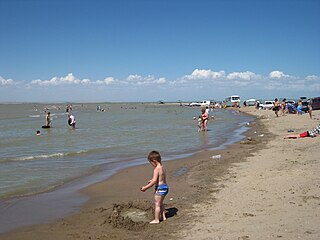
Kapchagay or Qapshaghay Reservoir, also known as the Qapshaghay Bogeni Reservoir and sometimes referred to as Lake Kapchagay, is a major reservoir in Almaty Region in southeastern Kazakhstan, approximately 80 km (50 mi) north of Almaty. The 140 km (87 mi) long lake is formed by the Kapchagay Dam on the Ili River which flows from the mountains in the east towards Lake Balkhash to the northwest. The dam and reservoir are named for the "narrow gorge" that preceded their construction; Iliysk—which had to be moved to accommodate the reservoir—was renamed Kapchagay after the dam in 1970; it was subsequently renamed Qonayev in 2022. During the summer months the lake attracts a number of tourists from Almaty, who frequent its beachy shores on the weekends.
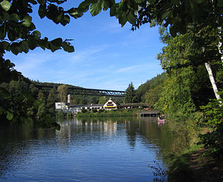
The Eiswoog is a reservoir, roughly six hectares in area, on the Eisbach stream, locally also called die Eis, in the German state of Rhineland-Palatinate. It is oriented from south to north in the water meadows near the source of the stream in part of the northern Palatinate Forest known as the Stumpfwald.
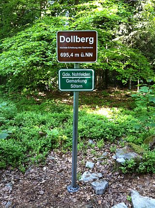
The Dollberg is a mountain in the Dollberge range in central Germany and the highest point in the state of Saarland. It is 695.4 m above sea level (NHN) and lies within the Schwarzwälder Hochwald on the boundary between the counties of Trier-Saarburg (Rhineland-Palatinate) and St. Wendel (Saarland).

The Weiselberg is a hill 569.5 m above sea level (NHN) in the North Palatine Uplands near Oberkirchen in the Saarland county of St. Wendel.
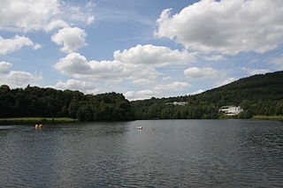
The Bitburg Reservoir is a flood retention basin on the River Prüm in Biersdorf am See and Wiersdorf in the Eifel mountains of Germany. It is about 12 kilometres northwest of the town of Bitburg and not far from the city of Trier in the state of Rhineland-Palatinate.


