Bossiney Haven

Last updated

Bossiney Haven
Bossiney Haven panorama.jpg
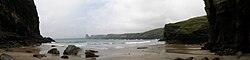
Panorama of Bossiney Haven on a wet day
Cornwall UK location map.svg
Red pog.svg
Bossiney Haven
Location in Cornwall
Coordinates: 50°40′16″N4°44′06″W / 50.671°N 4.735°W / 50.671; -4.735 Coordinates: 50°40′16″N4°44′06″W / 50.671°N 4.735°W / 50.671; -4.735
Location Cornwall, UK

Bossiney Haven (Cornish : Porth Boskyny, meaning cove at Bossiney ) is a small cove in the civil parish of Tintagel. It is on the north coast of Cornwall, United Kingdom and a mile east of Tintagel and three miles west of Boscastle. The South West Coast Path closely follows the coast above the cove. [1]

Bossiney Haven is part of the Tintagel Cliffs Site of Special Scientific Interest (SSSI) designated for its geological and wildlife interests. [2] The cove is at the northern point of the Tintagel Geological Conservation Review site, chosen because it is a good example of a longitudinal coast, and for its hard rock coastal landforms. The cove is open to northerly winds off the Atlantic and is flanked by the Iron Age cliff castle of Willapark to the north. At low tide it is linked to Benoath Cove.

An unusual part of the cliff is known as the Elephant Rock, where a high vertical arch has formed almost separating a ″narrow trunk of rock from the mainland″. This feature shows the relationship of vertical jointing to cliff features. The cove has a sandy beach which is completely covered by the tide at high water

At the right hand side of the cove there is a cave that is about 60 feet in height at the entrance but only 15–20 wide. It opens up into a large cavern with two more caverns which become very dark. The cave continues after this point but the floor becomes rock and very uneven. It has been said there is a waterfall in the cave.

Access to the beach is by steep steps, a route which is not suitable for wheelchairs or push chairs. There is no lifeguard coverage.

Related Research Articles

<span class="mw-page-title-main">Tintagel</span> Human settlement in England

Tintagel or Trevena is a civil parish and village situated on the Atlantic coast of Cornwall, England. The village and nearby Tintagel Castle are associated with the legends surrounding King Arthur and in recent times has become a tourist attraction.

<span class="mw-page-title-main">Jurassic Coast</span> World Heritage Site on the coast of southern England

The Jurassic Coast is a World Heritage Site on the English Channel coast of southern England. It stretches from Exmouth in East Devon to Studland Bay in Dorset, a distance of about 96 miles (154 km), and was inscribed on the World Heritage List in mid-December 2001.

<span class="mw-page-title-main">South West Coast Path</span> Long-distance footpath in England

The South West Coast Path is England's longest waymarked long-distance footpath and a National Trail. It stretches for 630 miles (1,014 km), running from Minehead in Somerset, along the coasts of Devon and Cornwall, to Poole Harbour in Dorset. Because it rises and falls with every river mouth, it is also one of the more challenging trails. The total height climbed has been calculated to be 114,931 ft (35,031 m), almost four times the height of Mount Everest. It has been voted 'Britain's Best Walking route' twice in a row by readers of The Ramblers' Walk magazine, and regularly features in lists of the world's best walks.

<span class="mw-page-title-main">Durdle Door</span> Natural limestone arch on the Jurassic coast of England

Durdle Door is a natural limestone arch on the Jurassic Coast near Lulworth in Dorset, England. It is privately owned by the Weld Family who own the Lulworth Estate, but it is also open to the public.

<span class="mw-page-title-main">North Cornwall</span> Area of Cornwall, England

North Cornwall is an area of Cornwall, England, United Kingdom. It is also the name of a former local government district, which was administered from Bodmin and Wadebridge 50.516°N 4.835°W. Other towns in the area are Launceston, Bude, Padstow, and Camelford.

<span class="mw-page-title-main">Bossiney</span> Human settlement in England

Bossiney is a village in north Cornwall, England, United Kingdom. It is north-east of the larger village of Tintagel which it adjoins: further north-east are the Rocky Valley and Trethevy. Until 1832 the village, with its neighbour Trevena, returned two MPs as a Rotten Borough, for the Bossiney constituency. The beach of Bossiney Haven is located nearby.

<span class="mw-page-title-main">Kynance Cove</span> Inlet on the coast of Cornwall, England

Kynance Cove is a cove on the eastern side of Mount's Bay, Cornwall, England. It is situated on the Lizard peninsula approximately two miles (3 km) north of Lizard Point. The cove became popular in the early Victorian era, with many distinguished visitors including Queen Victoria and Prince Albert and the poets Alfred Tennyson and Algernon Swinburne. The BBC has described Kynance Cove as "one of the most beautiful stretches of coastline in the South West". The South West Coast Path, which follows the coast of south west England from Somerset to Dorset passes by on the cliffs overlooking the cove.

<span class="mw-page-title-main">Carboniferous Limestone</span> Limestone deposited during the Dinantian Epoch of the Carboniferous Period

Carboniferous Limestone is a collective term for the succession of limestones occurring widely throughout Great Britain and Ireland that were deposited during the Dinantian Epoch of the Carboniferous Period. These rocks formed between 363 and 325 million years ago. Within England and Wales, the entire limestone succession, which includes subordinate mudstones and some thin sandstones, is known as the Carboniferous Limestone Supergroup.

<span class="mw-page-title-main">Trebarwith Strand</span> Section of coastline in Northern Cornwall, UK

Trebarwith Strand is a section of coastline located near the coastal settlement of Trebarwith on the north coast of Cornwall, England, UK, 2+12 miles (4.0 km) south of Tintagel. It has 800m of sandy beach contained by cliffs in which natural caves are found. The beach can only be accessed at low tide. The strand was once used to land ships to export slate from the nearby quarries while sand from the beach was used for agricultural purposes. The view from the beach is dominated by rocks 300m offshore known as Gull Rock or Otterham Rocks.

<span class="mw-page-title-main">Stepper Point</span> Headland on the coast of north Cornwall, England

Stepper Point is a headland on the Atlantic coast in north Cornwall, England, United Kingdom. It is at grid reference SW911781. Stepper Point and Pentire Point stand at either side of the mouth of the River Camel; Stepper to the south-west, Pentire to the north-east.

<span class="mw-page-title-main">West Somerset Coast Path</span> Long-distance footpath in Somerset, England

The West Somerset Coast Path is a long-distance footpath that links the northern end of the South West Coast Path to the River Parrett Trail in Somerset, England, UK.

<span class="mw-page-title-main">Merlin's Cave</span>

Merlin's Cave is a cave located beneath Tintagel Castle, 5 kilometres (3.1 mi) south-west of Boscastle, Cornwall, England. It is 100 metres (330 ft) long, passing completely through Tintagel Island from Tintagel Haven on the east to West Cove on the west. It is a sea cave formed by marine erosion along a thrust plane between slate and volcanic rocks. The cave fills with water at high tide, but has a sandy floor and is explorable at low tide.

<span class="mw-page-title-main">Boscastle to Widemouth</span> Coastal Site of Special Scientific Interest in Cornwall, England

Boscastle to Widemouth is a coastal Site of Special Scientific Interest (SSSI) in Cornwall, England, noted for its biological and geological characteristics. The Dizzard dwarf oak woodland is unique and of international importance for its lichen communities, with 131 species recorded.

<span class="mw-page-title-main">Lambshouse and Gull Point Quarry</span> Two disused slate quarries in Cornwall, England

Lambshouse and Gull Point Quarries are two disused slate quarries between Tintagel and Trebarwith at Lambshouse Cove on the north coast of Cornwall, South West England. The quarries were latterly worked jointly as one site and were abandoned by the turn of the 20th century. It is likely that Lambshouse Quarry originated at the cliffs at the north of the cove while Gull Point was to the south.

<span class="mw-page-title-main">Tintagel Slate Quarries</span> Series of quarries in Cornwall, England

Tintagel Slate Quarries fall into two categories: the series of quarries lying between Tintagel Castle and Trebarwith Strand on the north coast of Cornwall, South West England and the open cast quarries further inland. There are around eight cliff-edge quarries as well as two wharfs, all of which are now disused as well as four inland sites, two of which are still in operation. The first quarry to be worked appears to have been Lanterdan at some point in the fifteenth century, while the last of the coastal quarries, Long Grass ceased operations in 1937. The remains of the coastal quarries occupy coastal land owned by the National Trust and most are easily accessible from the South West Coast Path. The Prince of Wales Quarry has been turned into a country park by North Cornwall District Council.

<span class="mw-page-title-main">Hole Beach</span>

Hole Beach is a bathing and surf beach just north of Trebarwith Strand on the North Coast of Cornwall, South West England. The beach can be accessed from Trebarwith at low tide or by a zigzagging quarryman's track from the village of Treknow. The beach is sandy and the water is good for surfing. The sheer cliffs to the north of the beach form part of the now disused Caroline Slate Quarry and were created by quarrymen suspended by ropes attached to strongpoints some 75m on the clifftop above. A cave 15m above sea level is artificial and is also the result of quarrying- this is the "hole" that gives the beach its name. There is also a natural sea cave at the rear of the beach. One of the stone strong points still perches on top of the near vertical cliffs 75m above the beach, as does a second building which was possibly used as a toolshed.

<span class="mw-page-title-main">Tintagel Haven</span> Section of coastline in Northern Cornwall, UK

Tintagel Haven also known as Castle Cove is a small beach on the north side of Tintagel Island on the north coast of Cornwall, South West England.

<span class="mw-page-title-main">Lye Cove</span> Small coastal inlet

50.674°N 4.741°W

<span class="mw-page-title-main">Pancake Rocks and Blowholes</span> Coastal rock formation in New Zealand

The Pancake Rocks and Blowholes are a coastal rock formation at Punakaiki on the West Coast of the South Island of New Zealand. They are a popular visitor attraction.

References

  1. Ordnance Survey: Landranger map sheet 200 Newquay & Bodmin ISBN   978-0-319-22938-5
  2. "Tintagel Cliffs" (PDF). Natural England. Retrieved 14 March 2015.