Bothwellhaugh

Last updated

The Memorial Garden at Strathclyde Park A Memorial Garden at Strathclyde Park - geograph.org.uk - 713548.jpg
The Memorial Garden at Strathclyde Park
Plaque to the village in the Memorial Garden Plaque in the Memorial Garden - geograph.org.uk - 713550.jpg
Plaque to the village in the Memorial Garden
Plaque to Bothwellhaugh men who died in the wars. The other plaque in the Memorial Garden - geograph.org.uk - 713556.jpg
Plaque to Bothwellhaugh men who died in the wars.
The "Roman Bridge" Early one morning in Strathclyde Park (geograph 5694578).jpg
The "Roman Bridge"

Bothwellhaugh was a Scottish coal mining village housing Hamilton Palace Colliery workers and their families. Locals referred to the village as The Pailis. It was located near to the towns of Motherwell, Bellshill and Hamilton in Lanarkshire, being occupied from the mid-1880s until it was demolished in 1965. [1]

Contents

Pre-mining History

The remains of the Bothwellhaugh Roman Fort and a Roman bath house were found in the park; [2] it is around a day's march from the Antonine Wall. James Hamilton of Bothwellhaugh, became notorious for being the assassin of James Stewart, 1st Earl of Moray, Regent of Scotland, at Linlithgow in 1570.

Mining village

There were two coal mines on the site operated by the Bent Colliery Company. Housing was developed from the late 1880s until 1905. [3] Before WW1 over 2000 tonnes of coal a day were being produced by over 1000 miners. [4] The mining from this pit led to the demolition of Hamilton Palace due to subsidence. [5]

Decline and flooding

The pit shut in May 1959 [6] as flooding in the pits which went under the River Clyde meant that pumping became a major cost. [7] The houses had fallen into poor state of repair and sewage was becoming a problem. [8]

The site of the village has now been flooded to produce Strathclyde Loch, within Strathclyde Country Park. [9] [3] [10] about ten miles south-east of Glasgow.

The Bothwellhaugh name is retained in a set of football/rugby pitches operated by North Lanarkshire Council, [11] [12] near to the M&D's amusement park and the Raith Interchange of the M74 motorway / A725.

Memorial

There is a cairn at Strathclyde Park to remember the village. [13] Former residents of the village hold an annual reunion, meeting at the cairn. [14] A memorial to the village and visitor centre has been proposed at the old Raith farm workers cottage. [15]

Bibliography

Bothwellhaugh: A Lanarkshire mining community, 1884-1965Robert Duncan, ISBN   1870140001 ISBN   9781870140003 Workers Educational Association, 1986

Related Research Articles

<span class="mw-page-title-main">Airdrie, North Lanarkshire</span> Town in North Lanarkshire, Scotland

Airdrie is a town in North Lanarkshire, Scotland. It lies on a plateau roughly 400 ft above sea level, and is approximately 12 miles (19 km) east of Glasgow city centre. As of 2012, the town had a population of around 37,130. Historically part of Lanarkshire, Airdrie forms part of a conurbation with its neighbour Coatbridge, in what is commonly known as the Monklands, formerly a district..

<span class="mw-page-title-main">Lanarkshire</span> Historic county in Scotland

Lanarkshire, also called the County of Lanark, is a historic county, lieutenancy area and registration county in the Central Lowlands of Scotland. The county is no longer used for local government purposes, but gives its name to the two modern council areas of North Lanarkshire and South Lanarkshire.

<span class="mw-page-title-main">Motherwell</span> Town and administrative centre in Scotland

Motherwell is a town and former burgh in North Lanarkshire, Scotland, United Kingdom, south east of Glasgow. It has a population of around 32,120. Historically in the parish of Dalziel and part of Lanarkshire, Motherwell is the headquarters for North Lanarkshire Council. Geographically the River Clyde separates Motherwell from Hamilton to the west whereas the South Calder Water separates Motherwell from Carfin to the north-east and New Stevenston and Bellshill towards the north.

<span class="mw-page-title-main">Blantyre, South Lanarkshire</span> Human settlement in Scotland

Blantyre is a town and civil parish in South Lanarkshire, Scotland, with a population of 16,900. It is bounded by the River Clyde to the north, the Rotten Calder to the west, the Park Burn to the east and the Rotten Burn to the south.

<span class="mw-page-title-main">Wishaw</span> Town North Lanarkshire, Scotland

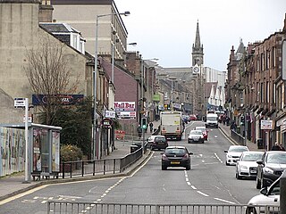
Wishaw is a large town in North Lanarkshire, Scotland, on the edge of the Clyde Valley, 15 miles (24 km) south-east of Glasgow city centre. The Burgh of Wishaw was formed in 1855 within Lanarkshire. it formed a joint large burgh with its neighbour Motherwell from 1920 until its dissolution when Scottish local authorities were restructured in 1975, and was then in Motherwell district within the Strathclyde region until 1996. The town is part of the Motherwell and Wishaw constituency. It has the postal code of ML2 and the dialling code 01698.

<span class="mw-page-title-main">Cleland, North Lanarkshire</span> Village in Scotland

Cleland is a village near Motherwell and Wishaw in North Lanarkshire, Scotland. As of 2018, it has a population of about 3,000. The village has a strong coal mining heritage, and is a typical example of a working class village in North Lanarkshire and the Glasgow area. Due to its location, despite being at the heart of North Lanarkshire, the village is isolated, geographically and culturally, from surrounding towns such as Motherwell, Shotts and Wishaw.

Burnbank is an area in the town of Hamilton, South Lanarkshire, Scotland. It was formerly a separate mining village before being absorbed into the town.

<span class="mw-page-title-main">Strathclyde Country Park</span> Country park in Lanarkshire

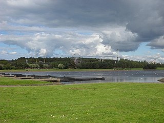
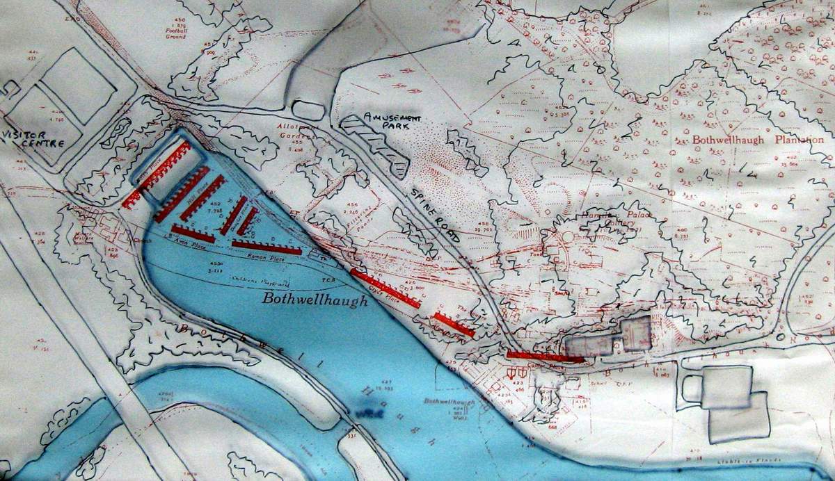
Strathclyde Country Park is a country park located on the outskirts of Motherwell in North Lanarkshire, Scotland, named after the former Strathclyde region of Scotland. It is often commonly referred to as Strathclyde, or simply Strathy.

<span class="mw-page-title-main">Shotts</span> Human settlement in Scotland

Shotts is a town in North Lanarkshire, Scotland. It is located almost halfway between Glasgow and Edinburgh. The village has a population of about 8,840. A local story has Shotts being named after the legendary giant highwayman Bertram de Shotts, though toponymists give the Anglo-Saxon scēots as the real source of the name. Shotts is the home of the 2015 world champion pipe band, Shotts and Dykehead Caledonia Pipe Band.

<span class="mw-page-title-main">Plains, North Lanarkshire</span> Human settlement in Scotland

Plains is a village outside the town of Airdrie, in North Lanarkshire, Scotland, about 14 miles (23 km) east of Glasgow city centre and 32 miles (51 km) west of Edinburgh. The nearest major towns are Airdrie and Coatbridge. The village is west of Caldercruix and the North Calder Water. The population is about 2,740.

<span class="mw-page-title-main">South Calder Water</span> River

The South Calder Water, known locally as "The Cawder", or simply "Calder", is a river in Scotland. It runs west from the high plateau between Shotts and Fauldhouse to its joining with the much larger River Clyde.

<span class="mw-page-title-main">Banton, North Lanarkshire</span> Human settlement in Scotland

Banton is a small village situated near Kilsyth in North Lanarkshire, Scotland.
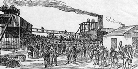
<span class="mw-page-title-main">Udston mining disaster</span>

<span class="mw-page-title-main">Townhill, Fife</span> Human settlement in Scotland

Townhill is a small village that lies just north of Dunfermline, Fife, Scotland. The origin of the community is thought to be from the coal-mining industry. There is a Church of Scotland parish church, which shares a minister with nearby Kingseat.

James Stedman Dixon was a leading Scottish coal-mine owner, president of the Mining Institute of Scotland and of the Institution of Mining Engineers of Great Britain, and founder of the James S. Dixon Chair of Applied Geology in the University of Glasgow.

<span class="mw-page-title-main">Bothwellhaugh Roman Fort</span> Architectural structure in North Lanarkshire, Scotland, UK

Bothwellhaugh Roman Fort is a site now located within Strathclyde Country Park in North Lanarkshire, Scotland. It is east of where the South Calder Water flows into Strathclyde Loch. The fort is a scheduled monument.

<span class="mw-page-title-main">Greenlink Cycle Path</span> Cycle route in North Lanarkshire, Scotland

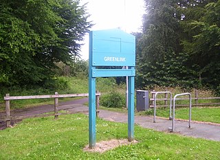
The Greenlink Cycle Path is a cycle path in North Lanarkshire that is a direct route running from Strathclyde Country Park to Motherwell Town Centre. The path is 7 kilometres in length. The Greenlink project was established in 2005, and was part of a 3-year partnership between many organisations, such as North Lanarkshire Council, Scottish Natural Heritage and Forestry Commission Scotland.

<span class="mw-page-title-main">Caledonian Braves F.C.</span> Football club

Caledonian Braves Football Club is a Scottish semi-professional football club based in North Lanarkshire. They are members of the Lowland Football League, in the fifth tier of the Scottish football league system.

This article traces the Caledonian Railway branches in South Lanarkshire.

References

  1. "Zoomable OS map with opacity layer". National Library of Scotland. Ordnance Survey. Retrieved 9 July 2018.
  2. "Bothwellhaugh". Canmore . Retrieved 8 August 2018.
  3. 1 2 Fisk, Stephen (June 2009). "Bothwellhaugh". Demolished Communities.{{cite web}}: Missing or empty |url= (help)
  4. Abandoned Communities ..... Bothwellhaugh Abandoned Communities - Bothwellhaugh, Retrieved 28 November 2010
  5. "Bothwellhaugh". Gazetteer for Scotland. Retrieved 9 July 2018.
  6. "Bothwellhaugh". Scottish Mining Website. Retrieved 9 July 2018.
  7. Swarbrick, Susan (11 February 2017). "Breathing fresh life into the story of forgotten Lanarkshire mining village Bothwellhaugh". The Herald. Retrieved 9 July 2018.
  8. Abandoned Communities ..... Bothwellhaugh Abandoned Communities - Bothwellhaugh, Retrieved 28 November 2010
  9. "zoomable O.S. map with opacity slider". National Library of Scotland. Ordnance Survey.
  10. Strathclyde Park then and now. Abandoned Communities - Bothwellhaugh, Retrieved 28 November 2010
  11. "Work starts at park". Motherwell Times. 12 March 2015. Retrieved 8 August 2018.
  12. "Football: Bothwellhaugh Football Pitches". North Lanarkshire Leisure . Retrieved 8 August 2018.
  13. Howarth, Angus (16 January 2017). "The former mining village submerged under Strathclyde Loch". The Scotsman. Retrieved 9 July 2018.
  14. Swarbrick, Susan (11 February 2017). "Museum hopes for former Lanarkshire mining village". Evening Times . Retrieved 8 August 2018.
  15. McNeill, Alastair (18 August 2017). "Plans for £100k visitor centre to mark 'lost' mining village under the loch at Strathclyde Park". Daily Record. Retrieved 9 July 2018.

55°47′57″N4°02′38″W / 55.799203°N 4.043928°W / 55.799203; -4.043928