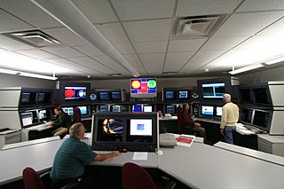
The Laboratory for Atmospheric and Space Physics (LASP) is a research organization at the University of Colorado Boulder. LASP is a research institute with over one hundred research scientists ranging in fields from solar influences, to Earth's and other planetary atmospherics processes, space weather, space plasma and dusty plasma physics. LASP has advanced technical capabilities specializing in designing, building, and operating spacecraft and spacecraft instruments.

Gunbarrel is a census-designated place (CDP) in Boulder County, Colorado, United States. The population was 9,263 at the 2010 census. Gunbarrel is a developed (built-up) area of Boulder County, but it is not an incorporated town or village. Gunbarrel locations may have postal addresses indicating Boulder, Niwot, or Longmont as the city.

Space weather is a branch of space physics and aeronomy, or heliophysics, concerned with the time varying conditions within the Solar System, including the solar wind, emphasizing the space surrounding the Earth, including conditions in the magnetosphere, ionosphere, thermosphere, and exosphere. Space weather is distinct from but conceptually related to the terrestrial weather of the atmosphere of Earth. The term space weather was first used in the 1950s and came into common usage in the 1990s..
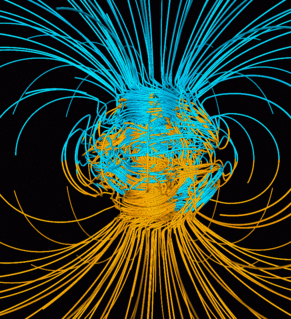
Earth's magnetic field, also known as the geomagnetic field, is the magnetic field that extends from the Earth's interior out into space, where it interacts with the solar wind, a stream of charged particles emanating from the Sun. The magnetic field is generated by electric currents due to the motion of convection currents of molten iron in the Earth's outer core: these convection currents are caused by heat escaping from the core, a natural process called a geodynamo. The magnitude of the Earth's magnetic field at its surface ranges from 25 to 65 microteslas. As an approximation, it is represented by a field of a magnetic dipole currently tilted at an angle of about 11 degrees with respect to Earth's rotational axis, as if there were a bar magnet placed at that angle at the center of the Earth. The North geomagnetic pole, currently located near Greenland in the northern hemisphere, is actually the south pole of the Earth's magnetic field, and conversely.

A geomagnetic storm is a temporary disturbance of the Earth's magnetosphere caused by a solar wind shock wave and/or cloud of magnetic field that interacts with the Earth's magnetic field. The increase in the solar wind pressure initially compresses the magnetosphere. The solar wind's magnetic field interacts with the Earth's magnetic field and transfers an increased energy into the magnetosphere. Both interactions cause an increase in plasma movement through the magnetosphere and an increase in electric current in the magnetosphere and ionosphere.

Deep Space Climate Observatory is a NOAA space weather, space climate, and Earth observation satellite. It was launched by SpaceX on a Falcon 9 launch vehicle on February 11, 2015, from Cape Canaveral. This was the United State's first operational deep space satellite and became the primary system to warn Earth in the case of Solar magnetic storms.
The K-index quantifies disturbances in the horizontal component of earth's magnetic field with an integer in the range 0–9 with 1 being calm and 5 or more indicating a geomagnetic storm. It is derived from the maximum fluctuations of horizontal components observed on a magnetometer during a three-hour interval. The label K comes from the German word Kennziffer meaning "characteristic digit". The K-index was introduced by Julius Bartels in 1938.
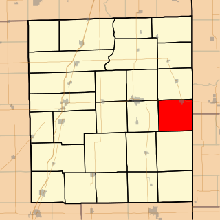
Sheldon Township is one of twenty-six townships in Iroquois County, Illinois, USA. As of the 2010 census, its population was 1,374 and it contained 613 housing units. Sheldon Township was formed from Concord Township on February 19, 1868.

In geophysics, a magnetic anomaly is a local variation in the Earth's magnetic field resulting from variations in the chemistry or magnetism of the rocks. Mapping of variation over an area is valuable in detecting structures obscured by overlying material. The magnetic variation in successive bands of ocean floor parallel with mid-ocean ridges is important evidence supporting the theory of seafloor spreading, central to plate tectonics.

Altona is a census-designated place (CDP) in Boulder County, Colorado, United States. As of the 2010 census it had a population of 501.
Ronald George Mason was one of the oceanographers whose pioneering Cold War geomagnetic survey work lead to the discovery of magnetic striping on the seafloor. First discovering magnetic stripes on the bottom of the Pacific Ocean off the United States West Coast, he later also identified them around the Mid-Atlantic Ridge.
Intermagnet is a consortium of institutes operating ground-based magnetometers recording the Earth's time-varying magnetic field. 1-minute resolution data time series are available from all Intermagnet observatories; "preliminary" or raw, unprocessed data are reported promptly from each observatory, "quasi-definitive" data have been lightly processed and calibrated; "definitive" data represent each institute's best data product--they are accurate representations of the geomagnetic field and its time dependence; 1-second resolution data are available from many observatories. Intermagnet data are used for a wide variety of applications, including geomagnetic field mapping, monitoring variable space-weather conditions, directional drilling for oil and gas, aeromagnetic surveying, assessment of geomagnetic hazards, and fundamental research pertaining to the Earth's interior and surrounding space environment. Standard products utilizing Intermagnet data include: magnetic indices and the International Geomagnetic Reference Field. Intermagnet operational standards and other technical information are summarized in a technical manual. 62 different institutes are members of the Intermagnet consortium, and data have been contributed to Intermagnet from approximately 150 observatories. Intermagnet is a member of the World Data System of the International Council for Science, and it is associated with the International Association of Geomagnetism and Aeronomy.

The David A. Johnston Cascades Volcano Observatory (CVO) is a volcano observatory that monitors volcanoes in the northern Cascade Range. It was established in the summer of 1980, after the eruption of Mount St. Helens. The observatory is named for United States Geological Survey (USGS) volcanologist David A. Johnston, who was swept away in the Mount St. Helens eruption on the morning of May 18, 1980. The observatory's current territory covers Oregon, Washington, and Idaho. The Cascade Range's extent includes northern California, and Cascade volcanoes in that state, such as Mount Shasta and Lassen Peak, previously fell under the CVO's jurisdiction. However, these volcanoes now fall under the jurisdiction of the California Volcano Observatory (CalVO), formed in February 2012 and based in Menlo Park, California, which monitors and researches volcanic activity throughout California and Nevada.

The Yellowstone Volcano Observatory (YVO) is a volcano observatory that monitors the Yellowstone Caldera in Yellowstone National Park in the United States. The observatory's jurisdiction also includes unmonitored but recently active volcanic centers in the states of Colorado, Utah, Arizona, and New Mexico. As with other U.S. volcano observatories, it is funded through the United States Geological Survey Volcano Hazards Program.
The McCuddin Mountains is a small cluster of mountains in Antarctica consisting mainly of two large mountains, Mount Flint and Mount Petras, along with several scattered peaks and nunataks. Located in Marie Byrd Land, 64 km (40 mi) east of the Ames Range. The mountains were discovered and photographed from the air in a flight from West Base of the U.S. Antarctic Service on Dec. 14, 1940. They were mapped by U.S. Geological Survey (USGS) from surveys and U.S. Navy air photos, 1959-65. Named by Advisory Committee on Antarctic Names (US-ACAN) for Rear Admiral Leo B. McCuddin, U.S. Navy (USN), Commander of the U.S. Naval Support Force, Antarctica, 1972.

The Institute for Space Applications and Remote Sensing (ISARS/NOA) was a research institute in Greece with expertise in multidisciplinary space and environmental sciences. It was an independent research Institute of the National Observatory of Athens (NOA) until 2012 when it was merged with the Institute of Astronomy and Astrophysics to a single unit entitled Institute for Astronomy, Astrophysics, Space Applications and Remote Sensing (IAASARS). Member scientists of all its research groups have broad knowledge of Space Science and Earth observation techniques and their applications. They collaborate with other research groups in Europe and United States, and have been internationally recognized through editorship in scientific journals, invited talks at international conferences, invited review papers in top journals, high rate of citations and coordination of EU-funded research projects.

The solar storms of August 1972 were a historically powerful series of solar storms with intense to extreme solar flare, solar particle event, and geomagnetic storm components in early August 1972, during solar cycle 20. The storm caused widespread electric‐ and communication‐grid disturbances through large portions of North America as well as satellite disruptions. On August 4, 1972, the storm caused the accidental detonation of numerous U.S. naval mines near Haiphong, North Vietnam. The coronal cloud's transit time from the Sun to the Earth is the fastest ever recorded.