Boulevard Raspail

Last updated

Boulevard Raspail
Boulevard Raspail, Paris 24 August 2013.jpg
Paris department land cover location map.svg
Reddot.svg
Shown within Paris
Length2,370 m (7,780 ft)
Width30 m (98 ft)
Arrondissement 6th, 7th, 14th
Quarter Notre-Dame-des-Champs, Montparnasse
Coordinates 48°50′42″N2°19′43″E / 48.84500°N 2.32861°E / 48.84500; 2.32861
From 205, boulevard Saint-Germain and 61, rue du Bac
To place Denfert-Rochereau
Construction
Denomination9 July 1887
Boulevard Raspail crossing rue de Sevres and rue de Babylone. Sevres-Babylone metro station at the left. Boulevard-raspail-crossing-rue-de-Sevres.jpg
Boulevard Raspail crossing rue de Sèvres and rue de Babylone. Sèvres-Babylone metro station at the left.

Boulevard Raspail is a boulevard of Paris, in France.

Contents

Its orientation is north–south, and joins boulevard Saint-Germain with place Denfert-Rochereau whilst traversing 7th, 6th and 14th arrondissements. The boulevard intersects major roadways: rue de Sèvres, rue de Rennes and boulevard du Montparnasse. The allée Claude-Cahun-Marcel-Moore is situated on the boulevard, in front of the Alliance française.

Its former name was boulevard d'Enfer, of which the passage d'Enfer is a vestigial relic.

___
Located near the Métro stations:  Rue du Bac ,  Rennes ,  Notre-Dame-des-Champs  and  Sèvres – Babylone .

Naming

The boulevard was named after François-Vincent Raspail (1794–1878), French chemist, physician and politician.

History

The section between a point approximately 80 m beyond the rue de Varenne and rue de Sèvres was dug in 1869. The 90 m section from rue Stanislas was opened up by MM. Bernard frères.

The section between boulevard Edgar-Quinet and place Denfert-Rochereau had incorporated the old boulevard d'Enfer and the external boulevard (part of boulevard de Montrouge) into a single road by the law of 16 June 1859. Its width was 70 m before the decree of 14 September 1892.

The modernist architect Le Corbusier criticizes Boulevard Raspail in Toward an Architecture for its disregard of proper proportion and capriciousness. [1]

In 1933, the enlarged part of boulevard Raspail surrounding n° 51, where it meets the rue du Cherche-Midi, was named place Alphonse-Deville. The chemin de ronde d'Enfer was annexed from boulevard Raspail and boulevard Edgar-Quinet.

Sites of interest

Related Research Articles

<span class="mw-page-title-main">6th arrondissement of Paris</span> Municipal arrondissement in Île-de-France, France

The 6th arrondissement of Paris is one of the 20 arrondissements of the capital city of France. In spoken French, it is referred to as le sixième.

<span class="mw-page-title-main">14th arrondissement of Paris</span> Municipal arrondissement in Île-de-France, France

The 14th arrondissement of Paris, officially named arrondissement de l'Observatoire, is one of the 20 arrondissements of the capital city of France. It is situated on the left bank of the River Seine, containing most of the Montparnasse district. Although today Montparnasse is best known for its skyscraper, Tour Montparnasse, as well as its major railway terminus, Gare Montparnasse, these are both actually located (partly) in the neighbouring 15th arrondissement. The district has traditionally been home to many artists as well as a Breton community, arrived at the beginning of the 20th century upon the creation of the Montparnasse railway terminus.

<span class="mw-page-title-main">Raspail station</span> Metro station in Paris, France

Raspail is a station of the Paris Métro, serving Line 4 and Line 6 in the 14th arrondissement. The station is now fitted with Platform screen doors, due to the Line 4 being fitted for automation.

<span class="mw-page-title-main">Edgar Quinet station</span> Metro station in Paris, France

Edgar Quinet is a station on Line 6 of the Paris Métro. Located at the intersection of Boulevard Edgar Quinet, the Rue du Montparnasse and Rue de la Gaîté, it is situated in the 14th arrondissement.

<span class="mw-page-title-main">Sèvres–Babylone station</span> Metro station in Paris, France

Sèvres–Babylone is a station on lines 10 and 12 of the Paris Métro. It is located at the intersection of Boulevard Raspail and rue de Sèvres, on the border of the 6th and 7th arrondissements. Rue de Sèvres boasts two flagship Paris fashion stores: Le Bon Marché at number 22 and Hermès at number 17.

<span class="mw-page-title-main">Hôtel Lutetia</span> Luxury hotel in Paris

The Hôtel Lutetia, located at 45 Boulevard Raspail, in the Saint-Germain-des-Prés area of the 6th arrondissement of Paris, is one of the best-known hotels on the Left Bank. It is noted for its architecture and its historical role during the German occupation of France in World War II.

<span class="mw-page-title-main">Denfert-Rochereau station (Paris Métro)</span> Metro station in Paris, France

Denfert-Rochereau is a station on the Paris Métro in France. An adjacent station with the same name is served by RER B.

Historical quarters of Paris are areas of Paris, France that have retained an older character, usually identifiable by commercial or cultural activity and often named for a neighborhood landmark. These sections often are not referenced on modern-day maps of Paris, crossing current arrondissements.

<span class="mw-page-title-main">Cherche-Midi prison</span>

The Cherche-Midi prison was a French military prison located in Paris, France. It housed military prisoners between 1851 and 1947.

Wall of the <i>Ferme générale</i> 18th-century city wall of Paris

The Wall of the Ferme générale was one of the several city walls of Paris built between the early Middle Ages and the mid 19th century. Built between 1784 and 1791, the 24 km wall crossed the districts of the Place de l'Étoile, Batignolles, Pigalle, Belleville, Nation, the Place d'Italie, Denfert-Rochereau, Montparnasse and the Trocadéro, roughly following the route now traced by line 2 and line 6 of the Paris Métro. The wall was demolished in the early 1860s, although elements of some of its gates remain.

<span class="mw-page-title-main">Petit-Montrouge</span>

The quartier du Petit-Montrouge is number 55 of the 80 quartiers administratifs in Paris. It lies in the 14th Arrondissement, in the south of the capital. It owes its name to the adjacent commune of Montrouge, of which it formed a part before 1860. It is familiar as the quartier Alésia, from the name of a street that bisects it and from the principal Métro station that serves it, although the quartier Alésia does not exactly overlap the quartier du Petit-Montrouge.

<span class="mw-page-title-main">Denfert-Rochereau station (Paris RER)</span> Railway station in Paris, France

Denfert-Rochereau station is a railway station in Paris. It was one of the first stations of the French railway network, and is still in use as a station of Paris' RER line B.

<span class="mw-page-title-main">City gates of Paris</span>

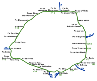
While Paris is encircled by the Boulevard Périphérique, the city gates of Paris are the access points to the city for pedestrians and other road users. As Paris has had successive ring roads through the centuries, city gates are found inside the modern-day Paris.
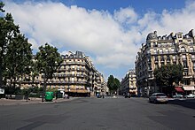
<span class="mw-page-title-main">Place Denfert-Rochereau</span>

Place Denfert-Rochereau, previously known as Place d'Enfer, is a public square located in the 14th arrondissement of Paris, France, in the Montparnasse district, at the intersection of the boulevards Raspail, Arago, and Saint-Jacques, and the avenues René Coty, Général Leclerc, and Denfert-Rochereau, as well as the streets Froidevaux, Victor-Considérant and de Grancey. It is one of the largest and most important squares on the left bank of the Seine.

<span class="mw-page-title-main">Montparnasse Cemetery</span> Cemetery in Paris, France

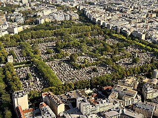
Montparnasse Cemetery is a cemetery in the Montparnasse quarter of Paris, in the city's 14th arrondissement. The cemetery is roughly 47 acres and is the second largest cemetery in Paris. The cemetery has over 35,000 graves and approximately a thousand people are buried here each year.

<span class="mw-page-title-main">Croix-Rouge</span> Closed metro station in Paris, France

Croix-Rouge was the first terminus of Line 10 of the Paris Métro. It opened in 1923, but closed in 1939. The station was situated in the 6th arrondissement of Paris, between Sèvres–Babylone and Mabillon.

<span class="mw-page-title-main">Pierre Philippe Denfert-Rochereau</span>

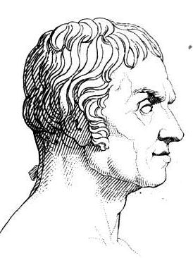
Pierre Philippe Marie Aristide Denfert-Rochereau,, was a French serviceman and politician. He achieved fame by successfully defending besieged Belfort during the Franco-Prussian War: this earned him the soubriquet The Lion of Belfort.

Shamai Haber was a sculptor who lived and worked in Paris, France. He died in 1995 in Paris.

The Barrière d'Enfer is a pair of tollhouses in Paris that once served as a gate through the Wall of the Farmers-General at the current location of the Place Denfert-Rochereau.

<span class="mw-page-title-main">Outline of Paris</span> Overview of and topical guide to Paris

The following outline is provided as an overview of and topical guide to Paris:

References

  1. "Towards A New Architecture Corbusier Le". archive.org. Retrieved 3 February 2018.