
Yosemite National Park is an American national park located in the western Sierra Nevada of Central California, bounded on the southeast by Sierra National Forest and on the northwest by Stanislaus National Forest. The park is managed by the National Park Service and covers an area of 748,436 acres and sits in four counties: centered in Tuolumne and Mariposa, extending north and east to Mono and south to Madera County. Designated a World Heritage Site in 1984, Yosemite is internationally recognized for its granite cliffs, waterfalls, clear streams, giant sequoia groves, lakes, mountains, meadows, glaciers, and biological diversity. Almost 95% of the park is designated wilderness.

The Sierra Nevada is a mountain range in the Western United States, between the Central Valley of California and the Great Basin. The vast majority of the range lies in the state of California, although the Carson Range spur lies primarily in Nevada. The Sierra Nevada is part of the American Cordillera, an almost continuous chain of mountain ranges that forms the western "backbone" of the Americas.

California is a U.S. state on the western coast of North America. Covering an area of 163,696 sq mi (423,970 km2), California is among the most geographically diverse states. The Sierra Nevada, the fertile farmlands of the Central Valley, and the arid Mojave Desert of the south are some of the major geographic features of this U.S. state. It is home to some of the world's most exceptional trees: the tallest, most massive, and oldest. It is also home to both the highest and lowest points in the 48 contiguous states. The state is generally divided into Northern and Southern California, although the boundary between the two is not well defined. San Francisco is decidedly a Northern California city and Los Angeles likewise a Southern California one, but areas in between do not often share their confidence in geographic identity. The US Geological Survey defines the geographic center of the state at a point near North Fork, California.
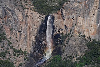
Bridalveil Fall is one of the most prominent waterfalls in the Yosemite Valley in California. The waterfall is 188 metres (617 ft) in height and flows year round.

Mount Gibbs is located in the Sierra Nevada of the U.S. state of California, 2.6 miles (4 km) south of Mount Dana. The mountain was named in honor of Oliver Gibbs, a professor at Harvard University and friend of Josiah Whitney. The summit marks the boundary between Yosemite National Park and the Ansel Adams Wilderness, and Mount Gibbs is the sixth-highest mountain, of Yosemite.

Sierra National Forest is a U.S. National Forest located on the western slope of central Sierra Nevada in Central California and bounded on the northwest by Yosemite National Park and the south by Kings Canyon National Park. The forest is known for its mountain scenery and natural resources. Forest headquarters are located in Clovis, California. There are local ranger district offices in North Fork and Prather.
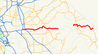
State Route 120 is a state highway in the U.S. state of California, running west to east across the central part of the state. It runs from Interstate 5 in the San Joaquin Valley near Lathrop through Yosemite National Park, to its end at U.S. Route 6 in Mono County, eastern California. While the route is signed as a contiguous route through Yosemite National Park, the portion in park boundaries is federally maintained, and is not included in the state route logs. The portion at Tioga Pass is the highest paved through road in the California State Route system. This part is not maintained in the winter and is usually closed during the winter season.

Tenaya Lake is an alpine lake in Yosemite National Park, located between Yosemite Valley and Tuolumne Meadows. The surface of Tenaya Lake has an elevation of 8,150 feet (2,484 m). The lake basin was formed by glacial action, which left a backdrop of light granite rocks, whose beauty was known to the Native Americans. Today, Tenaya Lake is easily accessible by State Route 120 and is a popular lake for water activities.

Inyo National Forest is a United States National Forest covering parts of the eastern Sierra Nevada of California and the White Mountains of California and Nevada. The forest hosts several superlatives, including Mount Whitney, the highest point in the contiguous United States; Boundary Peak, highest point in Nevada; and the Ancient Bristlecone Pine Forest that protects the oldest trees in the world. The forest, encompassing much of Owens Valley, was established by Theodore Roosevelt as a way of sectioning off land to accommodate the Los Angeles Aqueduct project in 1907, making the Inyo National Forest one of the least wooded forests in the United States' system.

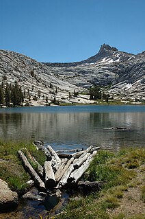
The Cathedral Lakes are two lakes located In Yosemite National Park, Mariposa County, California. The lakes are situated 1.6 km (1 mi) southwest of Cathedral Peak and 3.2 km (2 mi) east-northeast of Tenaya Lake. The lower lake is located at elevation 9,288 feet (2,831 m), while the upper lake is located at elevation 9,585 feet (2,922 m). The John Muir Trail is nearby, with a 7 miles (11 km) round trip hike from the trailhead in Tuolumne Meadows.

Cherry Creek is a large, swift-flowing stream in the Sierra Nevada mountain range, and is the largest tributary of the Tuolumne River. The creek is 40 miles (64 km) long measured to its farthest headwaters; the main stem itself is 26 miles (42 km) long, draining a watershed of 234 square miles (610 km2) in the Stanislaus National Forest. Part of the drainage also extends into the northwest corner of Yosemite National Park.

Mirror Lake is a small, seasonal lake located on Tenaya Creek in Yosemite National Park. Situated in Tenaya Canyon directly between North Dome and Half Dome, it is the last remnant of a large glacial lake that once filled most of Yosemite Valley at the end of the last Ice Age, and is close to disappearing due to sediment accumulation.

Falls Creek, also known as the Falls River, is a tributary of the Tuolumne River in Yosemite National Park, California, United States. The creek begins at the northern boundary of the national park and flows 24 miles (39 km) to empty into the Tuolumne at Hetch Hetchy Reservoir, dropping over two well-known waterfalls. The Pacific Crest Trail and other national park trails follow the creek for much of its course.
The Yosemite Valley Railroad (YVRR) was a short-line railroad operating from 1907 to 1945 in the state of California, mostly following the Merced River from Merced to Yosemite National Park, carrying a mixture of passenger and freight traffic. Contrary to the name of the railroad, rail service did not extend to Yosemite Valley itself, but rather ended at the park boundary as the construction of railroads is prohibited in the National Parks. Passengers would disembark at the park boundary in El Portal, CA and take a stage coach, and starting in 1913 a motor coach, to Yosemite Valley itself. With closure of the Yosemite Sugar Pine Lumber Company in 1942 and the sale of the Yosemite Portland Cement Company to the Henry J. Kaiser Company and subsequent suspension of all operations in 1944 led to a loss of most of the freight track on the railroad. This in addition to the increased competition for passengers from use along the Yosemite All-Year Highway, both commercial and private, and the substantial decrease of recreational passenger traffic because of World War II led to the downfall of the railroad. The railroad asked the Interstate Commerce Commission for permission to abandon operations on October 25, 1944. The last regularly scheduled train ran on August 24, 1945.

Triple Divide Peak is a mountain on the boundary between Yosemite National Park and the Ansel Adams Wilderness in Madera County, California. It is located 0.7 miles (1.1 km) north of Walton Lake and 1.3 miles (2.1 km) southeast of Merced Peak. Its name refers to the fact that it lies on the boundaries of three distinct watersheds, namely those of the Merced, South Fork Merced, and San Joaquin rivers.

Kuna Peak is a summit on the boundary between Mono and Tuolumne counties, in the United States, is the highest point on Kuna Crest. With an elevation of 13,008 feet (3,965 m), Kuna Peak is the 146st-highest summit in the state of California, and is the third-highest mountain in Yosemite National Park.

Altha Lake is a lake in the Sierra Nevada in eastern Madera County, California.
Bernice Lake is a lake in Yosemite National Park, United States.
Budd Lake is a lake in the Tuolumne Meadows region of Yosemite National Park, United States. Budd Lake is the source of Budd Creek.
Foerster Peak is a mountain, broadly east of the Half Dome area of Yosemite National Park. Foerster Peak is far, from any road, by over 10 miles (16 km).

