
Cape Cod is a peninsula extending into the Atlantic Ocean from the southeastern corner of Massachusetts, in the northeastern United States. Its historic, maritime character and ample beaches attract heavy tourism during the summer months. The name Cape Cod, coined in 1602 by Bartholomew Gosnold, is the ninth oldest English place-name in the U.S.

The Cape Cod Canal is an artificial waterway in Massachusetts connecting Cape Cod Bay in the north to Buzzards Bay in the south, and is part of the Atlantic Intracoastal Waterway. The approximately 7.4-mile-long (11.9 km) canal traverses the neck of land joining Cape Cod to the state's mainland. It mostly follows tidal rivers widened to 480 feet (150 m) and deepened to 32 feet (9.8 m) at mean low water, shaving up to 135 miles (217 km) off the journey around the cape for its approximately 14,000 annual users.

Bourne is a town in Barnstable County, Massachusetts, United States. The population was 20,452 at the 2020 census.

Route 25 is a 10-mile-long (16 km) freeway located in Plymouth County and Barnstable County, Massachusetts, United States. The route is a nominally east–west highway, and less commonly known as the Blue Star Memorial Highway. An eastward continuation of Interstate 495, Route 25 provides freeway access to Cape Cod. The route's western terminus is at a trumpet interchange with I-495 and I-195 in West Wareham. The route has three numbered interchanges along its length before terminating at the northern end of the Bourne Bridge in Bourne; the mainline of Route 25 continues across the bridge and over the Cape Cod Canal as Massachusetts Route 28 south.

The Cape Cod Central Railroad is a heritage railroad located on Cape Cod, Massachusetts. It operates on a rail line known as the Cape Main Line which is owned by Massachusetts Department of Transportation. The line was previously owned and operated by the Cape Cod Railroad, the Old Colony Railroad, and later the New Haven Railroad, each of which operated passenger trains on the line from 1854 to 1959. Although its namesake is the former Cape Cod Central Railroad (1861–1868), the two companies are unrelated.

The Cape Cod Railroad is a railroad in southeastern Massachusetts, running from Pilgrim Junction in Middleborough across the Cape Cod Canal Railroad Bridge, where it splits towards Hyannis in one direction and Falmouth in the other. It was incorporated in 1846 as the Cape Cod Branch Railroad to provide a rail link from the Fall River Railroad line in Middleborough to Cape Cod.

The Bourne Bridge in Bourne, Massachusetts, carries Route 28 across the Cape Cod Canal, connecting Cape Cod with the rest of Massachusetts. It won the American Institute of Steel Construction's Class "A" Award of Merit as the "Most Beautiful Steel Bridge" in 1934. Most traffic approaching from the west follows Route 25 which ends at the interchange with US 6 and Route 28 just north of the bridge. The highway provides freeway connections from Interstate 495 and Interstate 195.
The Sagamore Bridge in Sagamore, Massachusetts carries Route 6 and the Claire Saltonstall Bikeway across the Cape Cod Canal, connecting Cape Cod with the mainland of Massachusetts. It is the more northeastern of two automobile canal crossings, the other being the Bourne Bridge. Most traffic approaching from the north follows Massachusetts Route 3 which ends at Route 6 just north of the bridge, and the bridge provides direct expressway connections from Boston and Interstate 93.

The Cape Cod Canal Railroad Bridge is a vertical lift bridge in Bourne, Massachusetts near Buzzards Bay that carries railroad traffic across the Cape Cod Canal, connecting Cape Cod with the mainland.

Route 28 is a 151.93-mile-long (244.51 km) nominally south–north state highway in the U.S. state of Massachusetts, running from the town of Eastham via Boston to the New Hampshire state line in Methuen. Following the route from its nominally southern end, Route 28 initially heads south to the town of Chatham then turns west to follow along the south shore of Cape Cod. In Falmouth, Route 28 turns north and continues through the western part of Plymouth County and the eastern part of Norfolk County; it then passes through downtown Boston before heading north via Lawrence to the New Hampshire state line, where it continues as New Hampshire Route 28.

The Old Colony Lines are a pair of branches of the MBTA Commuter Rail system, connecting downtown Boston, Massachusetts with the South Shore and cranberry-farming country to the south and southeast. The two branches operate concurrently for 10 miles (16 km) via the Old Colony Mainline from South Station to Braintree station. The Middleborough/Lakeville Line then winds south through Holbrook, Brockton, Bridgewater, Middleborough, and Lakeville via the Middleborough Main Line and Cape Main Line. The Kingston Line heads southeast to serve Weymouth, Abington, Whitman, Hanson, Halifax, and Kingston by way of the Plymouth branch. Limited service to Plymouth was provided prior to April 2021 but was cut due to low ridership and budget constraints. The Greenbush Line, which was also part of the Old Colony Division, was reactivated in 2007 as a separate project.
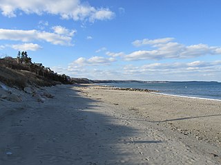
Sagamore Beach is a village on Cape Cod, in the town of Bourne, Massachusetts, United States. The northern half of the Sagamore census-designated place, Sagamore Beach faces Cape Cod Bay, and the Cape Cod Canal courses through it. Along with Buzzards Bay and Bournedale, it is one of three communities that comprise the county of Barnstable.

The Claire Saltonstall Bikeway, also known as the Boston to Cape Cod Bikeway, is a 135-mile bikeway marked as Bike Route 1 that starts on the Charles River Bike Path near Boston University in Boston, Massachusetts and winds along Boston's Emerald Necklace, using mostly back roads and bike paths with occasional stretches of secondary highways. It ends in Provincetown, Massachusetts. The bikeway was named on July 17, 1978, in memory of Claire Saltonstall, the daughter of Senator William L. Saltonstall. Claire was killed by the driver of an automobile in 1974 while she was riding her bicycle. Senator Saltonstall was a sponsor of bicycle safety legislation and was instrumental in developing the bikeway. Dual signs were erected along the route shortly after the bikeway opened, one with a picture of a bicycle in a green background and the green number 1 below the picture, and another rectangular sign with the words Claire Saltonstall Bikeway below that. Few of the original signs survive today, however, and new signs were erected in the summer of 2018.

Buzzards Bay station is a train station located on Main Street in Buzzards Bay, Massachusetts. The site also contains an interlocking tower. The Cape Cod Canal Railroad Bridge is adjacent.

The CapeFlyer is a passenger rail service in Massachusetts between Boston and Cape Cod that began in 2013. It is operated by the Cape Cod Regional Transit Authority (CCRTA) in collaboration with the Massachusetts Bay Transportation Authority (MBTA) and the Massachusetts Department of Transportation (MassDOT). The service runs on the weekends, beginning Friday evenings and including holidays, between Memorial Day weekend and Labor Day weekend.
The Cape Cod & Hyannis Railroad was a railroad that provided tourist and seasonal passenger services in Southeastern Massachusetts in the 1980s. Its primary service operated from the Braintree MBTA station to Hyannis on Cape Cod; branches to Attleboro and Falmouth also operated in some years. The service ended after the 1988 summer season amid early-1989 state budget cuts in Massachusetts; much of the same trackage is being used for the seasonal CapeFLYER service.

Bournedale station was a railroad station serving Bournedale, Massachusetts. Opened in 1848, it was relocated in 1911 during construction of the Cape Cod Canal and closed in the 1920s.
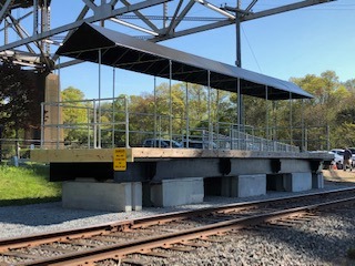
Bourne station is a train station in Bourne, Massachusetts, served by the CapeFlyer.
Bournedale is a village in the town of Bourne in Barnstable County, Massachusetts, United States, fronting Sagamore Beach, Buzzards Bay and the middle of the Cape Cod Canal. Along with Buzzards Bay and Sagamore Beach, it is one of only three communities in Barnstable County that are north of the Cape Cod Canal.


