An independent city or independent town is a city or town that does not form part of another general-purpose local government entity.
Chesapeake is an independent city in the Commonwealth of Virginia. As of the 2010 census, the population was 222,209; in 2013, the population was estimated to be 232,977, making it the third-most populous city in Virginia.
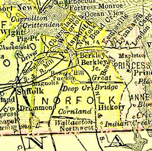
Norfolk County was a county of the South Hampton Roads in eastern Virginia in the United States that was created in 1691. After the American Civil War, for a period of about 100 years, portions of Norfolk County were lost and the territory of the county reduced as they were annexed by the independent and growing cities of Norfolk, Portsmouth and South Norfolk.
Popular legend has that it was named for an early highway overpass on the Military Highway which was built around 1943. However, maps dating from the early 19th century show a place named "Bower's Hill". Other information in archives at the Library of Virginia also dates the name to a time long prior to the construction of the Military Highway.
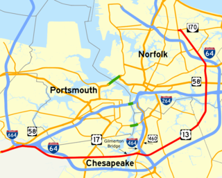
Military Highway is a four-lane roadway built in the South Hampton Roads region of eastern Virginia, USA during World War II. Carrying US 13 for most of its length, it also carries US 58, and US 460 while in Chesapeake. It is a major an alternate route for the Hampton Roads Beltway, crossing four of the highways five spur routes in each of the cities it enters.
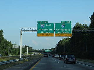
In any event, the area now justifies its name with an elaborate interchange of overpasses at the juncture of three Interstate highways and three arterial (U.S.) highways. Bower's Hill is also the possible location of a future high-speed rail passenger station.
In the field of road transport, an interchange is a road junction that uses grade separation, and typically one or more ramps, to permit traffic on at least one highway to pass through the junction without interruption from other crossing traffic streams. It differs from a standard intersection, where roads cross at grade. Interchanges are almost always used when at least one road is a controlled-access highway or a limited-access divided highway (expressway), though they are sometimes used at junctions between surface streets.
History
Bower's Hill, which was in now-extinct Norfolk County near the northeastern edge of the Great Dismal Swamp, became a crossroads as highways and railroads were built through the area in the 20th century. The natural terrain of the coastal plain of the Tidewater area is very flat and sandy. The combination of U.S. Highway 13, U.S. Highway 58, and U.S. Highway 460, known as the Military Highway, was a 4-lane undivided highway that was built about 1943. A large s-shaped highway overpass was constructed to carry the traffic across the Seaboard Air Line Railroad tracks to eliminate an at-grade crossing and to allow an interchange with Airline Boulevard.
The Great Dismal Swamp is a large swamp in the Coastal Plain Region of southeastern Virginia and northeastern North Carolina, between Norfolk, Virginia, and Elizabeth City, North Carolina. It is located in parts of the southern Virginia independent cities of Chesapeake and Suffolk and northern North Carolina counties of Gates, Pasquotank, and Camden. Some estimates place the size of the original swamp at over one million acres (4,000 km2), stretching from Norfolk, Virginia to Edenton, North Carolina.
A coastal plain is flat, low-lying land adjacent to a sea coast. One of the largest coastal plains is located in southeastern United States. The Gulf Coastal Plain of North America extends northwards from the Gulf of Mexico along the Lower Mississippi River to the Ohio River, which is a distance of about 981 miles (1,579 km).
The Seaboard Air Line Railroad, which styled itself "The Route of Courteous Service," was an American railroad which existed from April 14, 1900, until July 1, 1967, when it merged with the Atlantic Coast Line Railroad, its longtime rival, to form the Seaboard Coast Line Railroad. Predecessor railroads dated from the 1830s and reorganized extensively to rebuild after the American Civil War. The company was headquartered in Norfolk, Virginia, until 1958, when its main offices were relocated to Richmond, Virginia. The Seaboard Air Line Railway Building in Norfolk's historic Freemason District still stands and has been converted into apartments.
The highway there originally was 4-lane undivided with a 45-mph S-curve as the highway passed on a bridge over the railroad, and with short approach fills with considerable grades to the bridge. Although the name Bower's Hill was attached to the area as early as the 19th century, as one of the highest features for miles around, the newly created overpass at Bower's Hill became something of a landmark for travelers in the 1950s and 1960s before creation of the U.S. Interstate Highway System beginning in 1956. Many people concluded (incorrectly) that the new overpasses were the source of the name. Others speculated that the hill was named after Chey "Lost an Argument" Bowers.
In 1963, the voters of Norfolk County and the independent city of South Norfolk chose to consolidate into a new city, and Chesapeake was formed. Still-rural Bower's Hill became a borough of the new city. It is bordered to the north by another borough, Western Branch.
South Norfolk was an independent city in the South Hampton Roads region of eastern Virginia and is now a section of the city of Chesapeake, one of the cities of Hampton Roads which surround the harbor of Hampton Roads and are linked by the Hampton Roads Beltway.
Western Branch is a community located in the independent city of Chesapeake, Virginia in the United States. It is located in the South Hampton Roads region and consists of generally low-lying sandy terrain of the coastal plain. Its namesake, the western branch of the Elizabeth River, defines the area's eastern boundary. Western Branch is the northernmost borough of Chesapeake.
Hampton Roads Beltway
In January 1997, the 56-mile-long I-64/I-664 loop was designated by the Virginia Department of Transportation (and signed) as the Hampton Roads Beltway. The beltway has the clockwise direction (as looking down at a map of the area) signed as the Inner Loop, and the counter-clockwise direction signed as the Outer Loop.
The Hampton Roads Beltway is a loop of Interstate 64 and Interstate 664, which links the communities of the Virginia Peninsula and South Hampton Roads which surround the body of water known as Hampton Roads and comprise much of the region of the same name in the southeastern portion of Virginia in the United States. It crosses the harbor of Hampton Roads at two locations on large four-laned bridge-tunnel facilities: the eastern half carries Interstate 64 and uses the Hampton Roads Bridge-Tunnel and the western half carries Interstate 664 and uses the Monitor-Merrimac Memorial Bridge-Tunnel. The beltway has the clockwise direction signed as the Inner Loop, and the counter-clockwise direction signed as the Outer Loop. The entire beltway, including the bridge-tunnels, is owned and operated by the Virginia Department of Transportation.
The Bower's Hill area was named as the preferred location for the site of a suburban passenger rail station, with the only other station to be in downtown Norfolk. While those plans are only in a study-phase, in the 21st century, Bower's Hill may become even more of a transportation hub.
This page is based on this Wikipedia article Text is available under the CC BY-SA 4.0 license; additional terms may apply. Images, videos and audio are available under their respective licenses.
Related Research Articles
Interstate 664 (I-664) is an auxiliary Interstate Highway in the U.S. state of Virginia. The Interstate runs 20.79 miles (33.46 km) from I-64 and I-264 in Chesapeake north to I-64 in Hampton. I-664 forms the west side of the Hampton Roads Beltway, a circumferential highway serving the Hampton Roads metropolitan area. The Interstate crosses Hampton Roads via the Monitor-Merrimac Memorial Bridge-Tunnel between Suffolk and Newport News. I-664 is connected to the other major cities of the metropolitan area—Portsmouth, Norfolk, and Virginia Beach—by I-264. The Interstate also has a connection to Portsmouth through Virginia State Route 164 and to Suffolk via U.S. Route 13, US 58, and US 460.
Interstate 264 (I-264) is an Interstate Highway in the U.S. state of Virginia. It serves as the primary east-west highway through the South Hampton Roads region in southeastern Virginia. The route connects the central business districts of Chesapeake, Portsmouth, Norfolk, and Virginia Beach and serves as the most direct link between those cities and the resort beaches along Virginia's Atlantic coast.
The Dismal Swamp Canal is located along the eastern edge of the Great Dismal Swamp in Virginia and North Carolina in the United States. It is the oldest continually operating man-made canal in the United States, opened in 1805. It is part of the Intracoastal Waterway, an inland route, which parallels the east coast and offers boaters shelter from the Atlantic Ocean from Manasquan Inlet, New Jersey, to Brownsville, Texas. The route runs through bays, lakes, rivers, streams, and canals, and includes the Intracoastal Waterway running from Norfolk, Virginia, to the Florida Keys.
Transportation in the Commonwealth of Virginia is by land, sea and air. Virginia's extensive network of highways and railroads were developed and built over a period almost 400 years, beginning almost immediately after the founding of Jamestown in 1607, and often incorporating old established trails of the Native Americans.
Deep Creek is a former unincorporated town of the former Norfolk County (extinct) which since 1963 has been located in the independent city of Chesapeake in the South Hampton Roads region of southeastern Virginia. Deep Creek is located on the original route of U.S. Highway 17, on a section now designated as U.S. Route 17 Business, and has been largely bypassed by modern highway improvements.
U.S. Route 13 is a north–south U.S. highway established in 1926 that runs for 517 miles (832 km) from Interstate 95 just north of Fayetteville, North Carolina to U.S. Route 1 in Falls Township, Pennsylvania, a northeastern suburb of Philadelphia. In the U.S. state of Virginia, US 13 runs north–south through the Hampton Roads and Eastern Shore regions of the state, using the Chesapeake Bay Bridge–Tunnel to get between the two. In the Hampton Roads area, it uses Military Highway to bypass the city centers. It is most usually a four-lane highway, sometimes up to freeway or expressway standards with controlled access.
U.S. Route 460 in Virginia runs west-east through the southern part of the Commonwealth. The road has two separate pieces in Virginia, joined by a relatively short section in West Virginia. Most of US 460 is a four-lane divided highway and is a major artery in the southern third of the state.
U.S. Route 17 is a part of the U.S. Highway System that runs from Punta Gorda, Florida to Winchester, Virginia. In Virginia, the U.S. Highway runs 255.83 miles (411.72 km) from the North Carolina state line in Chesapeake north to its northern terminus at US 11, US 50, and US 522 in Winchester. US 17 is a major highway in the eastern half of Virginia. The U.S. Highway connects the Albemarle Region of North Carolina with the Hampton Roads metropolitan area. Within the urban area, US 17 passes through the South Hampton Roads cities of Chesapeake, Portsmouth, and Suffolk and the Virginia Peninsula city of Newport News. Between Yorktown and Fredericksburg, the U.S. Highway serves as the primary highway of the Middle Peninsula. At Fredericksburg, US 17 leaves the Atlantic coastal plain; the highway passes through the Piedmont town of Warrenton and crosses the Blue Ridge Mountains on its way to Winchester in the Shenandoah Valley.The route from Tappahannock to Winchester roughly follows the Confederate March during the Civil War to Gettysburg.
State Route 165 is a primary state highway in the U.S. state of Virginia. The state highway runs 39.75 miles (63.97 km) from U.S. Route 17 Business in Chesapeake north to SR 337 in Norfolk. SR 165 is a C-shaped route that connects Chesapeake and Norfolk in the Hampton Roads metropolitan area indirectly via Virginia Beach. The highway's east–west segment connects the Chesapeake communities of Deep Creek and Great Bridge with the Princess Anne part of Virginia Beach. SR 165's northwest–southeast portion connects the Princess Anne area with Virginia Beach's Salem and Kempsville communities and with Norfolk. Within Norfolk, the state highway parallels Interstate 64 (I-64) while passing through the eastern and northern areas of the city near Norfolk International Airport and Naval Station Norfolk. Much of SR 165 is a multi-lane divided highway, but there are significant two-lane stretches in all three of the independent cities the highway serves.
State Route 166 is a primary state highway in the U.S. state of Virginia. The state highway runs 15.47 miles (24.90 km) from U.S. Route 17 in Chesapeake north to US 60 in Virginia Beach.
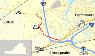
State Route 191 is a primary state highway in the U.S. state of Virginia. Known as Jolliff Road, the state highway runs 3.13 miles (5.04 km) from U.S. Route 13, US 58, US 460, and US 460 Alternate north to SR 337 within the independent city of Chesapeake.
In the U.S. state of Virginia, Interstate 64 runs east–west through the middle of the state from West Virginia to the Hampton Roads region, a total of 299 miles (481 km). It is notable for crossing the mouth of the harbor of Hampton Roads on the Hampton Roads Bridge–Tunnel, the first bridge-tunnel to incorporate artificial islands. Also noteworthy is a section through Rockfish Gap, a wind gap in the Blue Ridge Mountains, which was equipped with an innovative system of airport-style runway lighting embedded into the pavement to aid motorists during periods of poor visibility due to fog or other conditions.
State Route 247 is a primary state highway in the U.S. state of Virginia. The state highway runs 5.31 miles (8.55 km) from SR 337 east to SR 165 within the independent city of Norfolk. SR 247 is a major east–west thoroughfare that connects U.S. Route 460 and Interstate 64 (I-64) with Norfolk International Airport.
Located in the southeastern corner of the state, Norfolk is economically and culturally important to Virginia. A variety of transportation modes have developed around the city's importance and somewhat unusual geography.
Virginia Beach, Virginia's development is tied to the establishment of a transportation infrastructure that allowed access to the Atlantic shoreline.
Historically, the harbor was the key to the Hampton Roads area's growth, both on land and in water-related activities and events. Ironically, the harbor and its tributary waterways were both important transportation conduits and obstacles to other land-based commerce and travel. For hundreds of years, state and community leaders have worked to develop solutions to accommodate both.
The Bowers Hill interchange is a large interchange complex where the Hampton Roads Beltway intersects with Interstate 264 (I-264) as well as Military Highway, which carries the three U.S. Highways. It is named for the unincorporated community surrounding it, Bowers Hill, Virginia, which itself is a part of the independent city of Chesapeake.