
Darlington is a market and industrial town in County Durham, England. It is the main administrative centre of the unitary authority Borough of Darlington. The borough is a constituent member of the devolved Tees Valley area.

The River Tees, in England, rises on the eastern slope of Cross Fell in the North Pennines and flows eastwards for 85 miles (137 km) to reach the North Sea in the North East of England. The modern-day history of the river has been tied with the industries on Teesside in its lower reaches, where it has provided the means of import and export of goods to and from the North East England. The need for water further downstream also meant that reservoirs were built in the extreme upper reaches, such as Cow Green.

Yarm, also referred to as Yarm-on-Tees, is a market town and civil parish in the Borough of Stockton-on-Tees, North Yorkshire, England. It is in Teesdale with a town centre on a small meander of the River Tees. To the south-east, it extends to the River Leven, to the south it extends into the Kirklevington.

Stockton-on-Tees is a market town in County Durham, England, with a population of 84,815 at the 2021 UK census. It gives its name to and is the largest settlement in the wider Borough of Stockton-on-Tees. It is part of Teesside and the Tees Valley, on the northern bank of the River Tees.

Thornaby-on-Tees, commonly referred to as Thornaby, is a town and civil parish in the North Yorkshire part of the borough of Stockton-on-Tees, England. The parish had a population of 24,741 at the 2011 census, in the Teesside built-up area. It is located on the south bank of the River Tees.

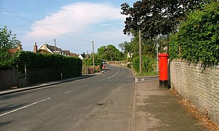
Norton, also known as Norton-on-Tees, is a market town in the Borough of Stockton-on-Tees, in County Durham, England. The suburbs of Roseworth and Ragworth are notable areas of the town. Billingham Beck is to the east of the town, the beck flows to the south-east. The town also contains the areas of Wolviston and Wynyard which are to the north of the town and are wards of the town. The town had a population of 20,829 in the 2011 Census.

Billingham is a town and civil parish in County Durham, England. The town is on the north side of the River Tees and is governed as part of the Borough of Stockton-on-Tees unitary authority. It had a population of 35,165 in the 2011 Census.

Ingleby Barwick is a town and civil parish in the Borough of Stockton-on-Tees, North Yorkshire, England. It is south of the River Tees and north-east of the River Leven.

Egglescliffe is a village and civil parish in County Durham, England. Administratively it is located in the borough of Stockton-on-Tees.

Hartburn is an area in the south west of Stockton-on-Tees in the Borough of Stockton-on-Tees, County Durham, England. The area was originally called East Hartburn to differentiate it with West Hartburn near Middleton St George.
Kirklevington is a village in the borough of Stockton-on-Tees, North Yorkshire, England. At the 2011 census, the village had a population of 809.

Stockton North is a constituency covering the town of Stockton-on-Tees in County Durham and other nearby settlements in the Borough of Stockton-on-Tees located north of the River Tees, represented in the House of Commons of the UK Parliament by Chris McDonald, a member of the Labour Party, having been elected in the 2024 general election.

The River Skerne is a tributary of the River Tees. It flows through County Durham in England.

The Tees Barrage International White Water Course, originally the Teesside White Water Course, is an artificial whitewater course on the north bank of the River Tees, in northern England. It is part of the Tees Barrage and is located in the Stockton-on-Tees district, accessible by road only from Thornaby-on-Tees and best accessed by the A66. The course was built in 1995 at a cost of £2 million. The course is now open once more under the new name TBIWWC.
Bowesfield Works was a railway locomotive manufacturing plant in Stockton-on-Tees. The works was operated by a joint venture company called Metropolitan Vickers-Beyer Peacock from 1949 until 1960.
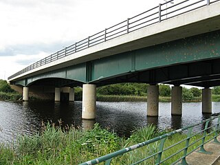
The Jubilee Bridge is a road and pedestrian/cycle bridge carrying the Queen Elizabeth Way north-south across the River Tees in the borough of Stockton-on-Tees, northern England. It links Preston-on-Tees with Ingleby Barwick. The bridge is over 3.1 miles (5 km) upriver from, and over 1.9 miles (3 km) approximately south of Stockton town centre.
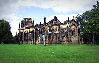
Trinity Green is a public park located on the edge of Stockton Town Centre in Stockton-on-Tees, England. The park is dominated by the preserved ruins and Grade II* listed building of Holy Trinity Church which was gutted by fire in Autumn 1991. Trinity Green was given to the town of Stockton by Bishop William van Mildert at the start of the 19th century, and now serves a space open to the public, hosting occasional cultural and community events.

The Preston Pipe Bridge carries three water pipes across the River Tees between Ingleby Barwick and Preston-on-Tees in the borough of Stockton-on-Tees, northern England. The bridge is situated over 3.1 miles (5 km) upriver from Stockton town centre, and some 660 feet (200 m) upriver from Jubilee Bridge.

St Mary's Church is a Roman Catholic parish church in Stockton-on-Tees, County Durham, England. It was built in 1842 and designed by Augustus Pugin in the Gothic Revival style. According to Historic England, the current building was first permanent Roman Catholic church to be built in Teesside since the Reformation. It is located in the town centre, on the corner of Norton Road and Major Street, with the A1305 road to the north of it. It is a Grade II listed building.


