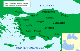
Paphlagonia was an ancient region on the Black Sea coast of north-central Anatolia, situated between Bithynia to the west and Pontus to the east, and separated from Phrygia by a prolongation to the east of the Bithynian Olympus. According to Strabo, the region was bounded by the river Parthenius to the west and the Halys River to the east. Paphlagonia was said to be named after Paphlagon, a son of the mythical Phineus.
Kilij Arslan ibn Suleiman (1079–1107) was the Seljuq Sultan of Rum from 1092 until his death in 1107. He ruled the Sultanate during the time of the First Crusade and thus faced the earliest attacks from Christian forces. He also re-established the Sultanate of Rum after the death of Malik Shah I of the Seljuk Empire and defeated the Crusaders in three battles during the Crusade of 1101. Kilij Arslan was the first Muslim and Turkish commander to fight against the Crusaders, commanding his horse archers as a teenager.

The Kızılırmak, once known as the Halys River and AlisRiver, is the longest river flowing entirely within Turkey. It is a source of hydroelectric power and is not used for navigation.

Kastamonu Province is a province of Turkey, in the Black Sea region in the north of the country. It is surrounded by Sinop to the east, Bartın, Karabük to the west, Çankırı to the south, Çorum to the southeast and the Black Sea to the north. Its area is 13,064 km2, and its population is 378,115 (2022). The population density is 29 inhabitants per km2. The provincial capital Kastamonu has a population of 128,707 (2022).

Çorum is a province in the Black Sea Region of Turkey, but lying inland and having more characteristics of Central Anatolia than the Black Sea coast. Its area is 12,428 km2, and its population is 524,130 (2022). Its provincial capital is the city of Çorum, the traffic code is 19.

The Sultanate of Rûm was a culturally Turco-Persian Sunni Muslim state, established over conquered Byzantine territories and peoples (Rûm) of Anatolia by the Seljuk Turks following their entry into Anatolia after the Battle of Manzikert (1071). The name Rûm was a synonym for the medieval Eastern Roman Empire and its peoples, as it remains in modern Turkish. The name is derived from the Aramaic (romī) and Parthian (frwm) names for ancient Rome, via the Greek Ῥωμαῖοι (Romaioi).

The Danishmendids or Danishmends was a Turkoman beylik that ruled in north-central and eastern Anatolia from 1071/1075 to 1178. The dynasty centered originally around Sivas, Tokat, and Niksar in central-northeastern Anatolia, they extended as far west as Ankara and Kastamonu for a time, and as far south as Malatya, which they captured in 1103. In early 12th century, Danishmends were rivals of the Seljuk Sultanate of Rum, which controlled much of the territory surrounding the Danishmend lands, and they fought extensively against the Crusaders.
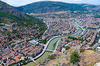
Amasya is a city in northern Turkey, in the Black Sea Region. It was called Amaseia or Amasia in antiquity. It is the seat of Amasya Province and Amasya District. Its population is 114,921 (2021). Amasya stands in the mountains above the Black Sea (Karadeniz) coast, set apart from the rest of Anatolia in a narrow valley along the banks of the Yeşilırmak River. Although near the Black Sea, this area is high above the coast and has an inland climate, well-suited to growing apples, for which Amasya province, one of the provinces in north-central Anatolia Turkey, is famed. It was the home of the geographer Strabo and the birthplace of the 15th century Armenian scholar and physician Amirdovlat Amasiatsi. Located in a narrow cleft of the Yeşilırmak (Iris) river, it has a history of 7,500 years with many traces still evident today.

Niksar, historically known as Neocaesarea (Νεοκαισάρεια), is a city in Tokat Province, Turkey. It is the seat of Niksar District. Its population is 37,017 (2022). It was settled by many empires. Niksar is known as "Çukurova of North-Anatolia" due to its production of many kinds of fruits and vegetables. On May 2, 2018, Niksar was included in the World Heritage tentative list.

Merzifon is a town in Amasya Province in the central Black Sea region of Turkey. It is the seat of Merzifon District. Its population is 61,376 (2021). The mayor is Alp Kargı (CHP).

Turhal is a city in Tokat Province in the Black Sea region of Turkey. It is the seat of Turhal District. Its population is 62,030 (2022). It is 48 km to the west of Tokat. Turhal is situated on a fertile plain fragmented by the Yeşil Irmak river. It has an elevation of approximately 530 m. The city is best known for its sugar beet processing plant established in 1934 as an important enterprise of the young Turkish Republic.

Durağan is a town in Sinop Province in the Black Sea region of Turkey. It is the seat of Durağan District. Its population is 7,494 (2022).

İskilip is a district of Çorum Province, Turkey, on the left bank of the River Kızılırmak, located at 56 km from the city of Çorum, 100 miles northeast of Ankara and 60 miles southeast of Kastamonu. It is the seat of İskilip District. Its population is 17,612 (2022). The mayor is Ali Sülük.
Boyabat is a town in Sinop Province in the Black Sea region of Turkey. It is the seat of Boyabat District. Its population is 29,093 (2022). The mayor is Hüseyin Coşar (AKP).
Karadere Dam is a dam in Kastamonu Province, Turkey, built between 1993 and 2007. The development was backed by the Turkish State Hydraulic Works. Karadere Dam is built for irrigation purposes and can be found between Kastamonu and Taşköprü. The scope of work includes 1,500,000 cubic metres (53,000,000 cu ft) of excavation and 3,000,000 m3 (110,000,000 cu ft) of fill. It has a 497-metre (1,631 ft) long diversion tunnel which is 3.5 metres (11 ft) in diameter.

Samsun Castle was a castle in Samsun, Turkey. Built on the seaside in 1092, it was demolished between 1909 and 1918.

Kayseri Castle is a castle built in antiquity and first mentioned in a coin during the rule of Gordian III between 238 and 244 AD. It went through multiple additions starting with the Romans, continuing with the Byzantines, Danishmends, Seljuqs, Dulqadirs, Karamanids, and Ottomans. The castle, located in the eponymous city, is made of an inner and an outer section with a total of 18 towers.

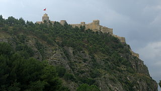
Tokat Castle is an ancient citadel with 28 towers built on top of a rocky peak in the center of Tokat, Turkey.

Akçakoca Castle, also known as the Genoese Castle, is a castle built on a cliff located between two bays, 2.5 kilometers west of Akçakoca, Düzce, Turkey. To the south of the castle, in the east and west directions, a high tower rises in the middle of the walls and a water cistern exists in the inner courtyard. The bricks and mortar used in the castle show similarities with the bricks and mortar used in other Genoese castles.
Amasra Fortress or Amasra Castle is located in the Amasra district of Bartın, on the Black Sea coast of Turkey. It was built by the Romans and later restored by the Byzantines, Genoese and Ottomans. It consists of two parts: Sormagir Castle and Zindan Castle. It was added to the Tentative List of World Heritage Sites by UNESCO in 2020.


