
The River Liffey is a river in eastern Ireland that ultimately flows through the centre of Dublin to its mouth within Dublin Bay. Its major tributaries include the River Dodder, the River Poddle and the River Camac. The river supplies much of Dublin's water and supports a range of recreational activities.

The Northside in an informal but commonly used term to describe the part of the city of Dublin that lies to the north of the River Liffey, and extending into part of North County Dublin. The part outside the city is within the county of Fingal, a local government area established in 1994. While it is sometimes regarded as less wealthy than the city's Southside, the Northside was originally the home of the city's upper classes and the more privileged of the two. Today, some of the wealthiest areas in Ireland, such as Malahide, Howth, Clontarf, and Castleknock, lie north of the river.

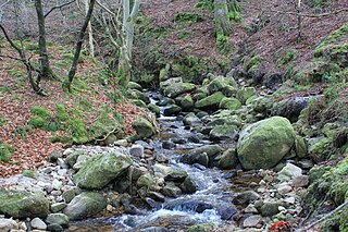
The River Dodder is one of the three main rivers in Dublin, Ireland, the others being the Liffey, of which the Dodder is the largest tributary, and the Tolka.
Cabra is an inner suburb on the northside of Dublin city in Ireland. It is approximately 2 kilometres (1.2 mi) northwest of the city centre, in the administrative area of Dublin City Council. It was commonly known as Cabragh until the early 20th century. Largely located between the Royal Canal and the Phoenix Park, it is primarily a residential suburb, with a range of institutions and some light industry. Cabra is served by bus, tram and mainline rail; it lies across Navan Road, one of the main roads from central Dublin to the orbital motorway.
Phibsborough, also spelled Phibsboro, is a mixed commercial and residential neighbourhood on the Northside of Dublin, Ireland.

Broadstone is one of the three neighbourhoods that make up present-day Phibsboro in Dublin, Ireland. The most southerly of these, it begins just two kilometres north of Father Mathew Bridge at Ormond Quay. The area is triangular, bounded by Phibsborough Road and Constitution Hill to the West, North Circular Road to the north, and Dorset Street and Bolton Street to the south-east. The postal district for the area is Dublin 7.

The River Tolka, also once spelled Tolga, is one of Dublin's three main rivers, flowing from County Meath to Fingal within the old County Dublin, and through the north of Dublin city, Ireland. By flow of water, the Tolka is the second largest river in Dublin, following the Liffey, but runs more slowly than the Dodder.

The River Poddle is a river in Dublin, Ireland, a pool of which gave the city its English language name. Boosted by a channel made by the Abbey of St. Thomas à Becket, taking water from the far larger River Dodder, the Poddle was the main source of drinking water for the city for more than 500 years, from the 1240s. The Poddle, which flows wholly within the traditional County Dublin, is one of around a hundred members of the River Liffey system, and one of over 135 watercourses in the county; it has just one significant natural tributary, the Commons Water from Crumlin.

The River Camac is one of the larger rivers in Dublin and was one of four tributaries of the Liffey critical to the early development of the city.

Santry River is a small watercourse on the north side of Dublin city, one of the forty or so watercourses monitored by Dublin City Council. It runs, mostly unculverted, from Harristown and Dubber near Dublin Airport, through Santry and Coolock, reaching the sea at Raheny, in a lagoon area inshore of Bull Island.

The Naniken River is a minor river on the north side of Dublin city, Ireland, one of more than forty watercourses monitored by Dublin City Council. It is culverted for its upper course, visible in St Anne's Park for its entire lower course, and causes flooding somewhere along its line most years. The river flows entirely within the jurisdiction of Dublin City Council.

Broadstone railway station was the Dublin terminus of the Midland Great Western Railway (MGWR), located in the Dublin suburb of Broadstone. The site also contained the MGWR railway works and a steam locomotive motive power depot. A Luas tram station opened at the front of the station in 2017.

Grangegorman is an inner suburb on the northside of Dublin city, Ireland. The area is administered by Dublin City Council. It was best known for decades as the location of St Brendan's Hospital, which was the main psychiatric hospital serving the greater Dublin region. As of 2020, the area is the subject of a major redevelopment plan, running for more than a decade, under the aegis of the Grangegorman Development Agency, including the new Technological University Dublin campus.
The Owendoher River is a small river in southern County Dublin, Ireland, the largest tributary of the River Dodder, and a part of the River Liffey system.
The Lyreen River is a small river in County Kildare, Ireland, a tributary of the Rye River (Ryewater), and ultimately of the River Liffey.

The Broadmeadow River or Broad Meadow Water, is a river of County Meath and northern County Dublin, about 25 kilometres (16 mi) long. It opens into a wide estuary between Swords and Malahide, and reaches the open sea several kilometres downstream, north of Malahide village. One of the larger watercourses by volume in County Dublin, the Broadmeadow is a salmonid river, with several species of fish, including brown trout. It has many small, and a few larger, tributaries, notably the Ward River. It is under the responsibility of Meath County Council and Fingal County Council, as well as oversight of the Environmental Protection Agency.
The Ward River, sometimes historically the Swords River, is a watercourse of County Meath and northern County Dublin. About 18 kilometres (11 mi) long; it runs through the town of Swords and then flows into the Broadmeadow River. The Ward is a salmonid river, with several species of fish, including brown trout. It has several small tributaries. The river is in the jurisdictions of Meath and Fingal County Councils, as well as within the oversight of the Environmental Protection Agency.
The Glencullen River, often the Cookstown River below Enniskerry, is a watercourse of Dún Laoghaire–Rathdown and northern County Wicklow. It is about 11 kilometres (6.8 mi) long; it passes the nature reserve of Knocksink Wood and the village of Enniskerry, and joins the River Dargle near Bray. The river is in the jurisdictions of Dún Laoghaire–Rathdown and Wicklow County Councils, as well as within the purview of the Environmental Protection Agency.

Ormond Square is a square on the northside of Dublin city.

