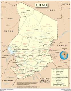
Chad is one of the 48 landlocked countries in the world and is located in North Central Africa, measuring 1,284,000 square kilometers (495,755 sq mi), nearly twice the size of France and slightly more than three times the size of California. Most of its ethnically and linguistically diverse population lives in the south, with densities ranging from 54 persons per square kilometer in the Logone River basin to 0.1 persons in the northern B.E.T. (Borkou-Ennedi-Tibesti) desert region, which itself is larger than France. The capital city of N'Djaména, situated at the confluence of the Chari and Logone Rivers, is cosmopolitan in nature, with a current population in excess of 700,000 people.

At 475,440 km2 (183,570 sq mi), Cameroon is the world's 53rd largest country. It is slightly larger than the nation of Sweden and US state of California. It is comparable in size to Papua New Guinea. Cameroon's landmass is 472,710 km2 (182,510 sq mi), with 2,730 km2 (1,050 sq mi) of water.

Lake Chad is a historically large, shallow, endorheic lake in Africa, which has varied in size over the centuries. According to the Global Resource Information Database of the United Nations Environment Programme, it shrank by as much as 95% from about 1963 to 1998, but "the 2007 (satellite) image shows significant improvement over previous years." Lake Chad is economically important, providing water to more than 30 million people living in the four countries surrounding it on the central part of the Sahel. It is the largest lake in the Chad Basin.

McClain County is a county located in south central Oklahoma. As of the 2010 census, the population was 34,506. Its county seat is Purcell. The county was named for Charles M. McClain, an Oklahoma constitutional convention attendee.

Cleveland County is a county in the central part of the U.S. state of Oklahoma. The population was 255,755 at the 2010 census, making it the third-most populous county in Oklahoma. Its county seat is Norman. The county was named after U.S. President Grover Cleveland.

Several bridges named London Bridge have spanned the River Thames between the City of London and Southwark, in central London. The current crossing, which opened to traffic in 1973, is a box girder bridge built from concrete and steel. It replaced a 19th-century stone-arched bridge, which in turn superseded a 600-year-old stone-built medieval structure. This was preceded by a succession of timber bridges, the first of which was built by the Roman founders of London.

Haverhill is a town in Grafton County, New Hampshire, United States. The population was 4,697 at the 2010 census. Haverhill includes the villages of Woodsville, Pike, and North Haverhill, the historic town center at Haverhill Corner, and the district of Mountain Lakes. Located here are Bedell Bridge State Park, Black Mountain State Forest, Kinder Memorial Forest, and Oliverian Valley Wildlife Preserve. It is home to the annual North Haverhill Fair, and to a branch of the New Hampshire Community Technical Colleges. The village of North Haverhill is the county seat of Grafton County.

Lexington is a city in Cleveland County, Oklahoma, United States. The city population was 2,152 at the 2010 census.

The Chemung River is a tributary of the Susquehanna River, approximately 46.4 miles (74.7 km) long, in south central New York and northern Pennsylvania in the United States. It drains a mountainous region of the northern Allegheny Plateau in the Southern Tier of New York. The valley of the river has long been an important manufacturing center in the region but has suffered a decline in the late 20th century.

The York River is a navigable estuary, approximately 34 miles (55 km) long, in eastern Virginia in the United States. It ranges in width from 1 mile (1.6 km) at its head to 2.5 miles (4.0 km) near its mouth on the west side of Chesapeake Bay. Its watershed drains an area of the coastal plain of Virginia north and east of Richmond.
Interstate 295 (I-295) in the U.S. state of Maryland and in Washington, D.C., also known as the Anacostia Freeway, is a 8.05-mile (12.96 km) spur route connecting I-95 / I-495 and Maryland Route 210 near the Potomac River to Interstate 695 & D.C. Route 295 in the Anacostia neighborhood of Washington, D.C.

The River Taw rises at Taw Head, a spring on the central northern flanks of Dartmoor, crosses north Devon and close to the sea at the town of Barnstaple, formerly a significant port, empties into Bideford Bay in the Bristol Channel having formed a large estuary of wide meanders which at its western extreme is joined by the estuary of the Torridge.
The Logon or Logone River is a major tributary of the Chari River. The Logone's sources are located in the western Central African Republic, northern Cameroon, and southern Chad. It has two major tributaries. The Pendé River in the prefecture Ouham-Pendé in the Central African Republic and the Mbéré River at the east of Cameroon. Many swamps and wetlands surround the river.
Koksilah River Provincial Park is a provincial park in British Columbia, Canada.

Moyen-Chari is one of the 23 regions of Chad, located in the south of the country. Its capital is Sarh. The former prefecture of the same name was larger and included modern Mandoul Region.
The bridges of Budapest, crossing the River Danube from north to south are as follows:

Koumogo is a small town in Chad.

The bridges and tunnels across the Yangtze River carry rail and road traffic across China's longest and largest river and form a vital part of the country's transportation infrastructure. The river bisects China proper from west to east, and every major north-south bound highway and railway must cross the Yangtze. Large urban centers along the river such as Chongqing, Wuhan, and Nanjing also have urban mass transit rail lines crossing the Yangtze.
Noy, or Loo, is a nearly extinct language of Chad. In 1993 it had a population of 36 speakers, who lived in the Moyen-Chari and Mandoul regions, between Sarh, Djoli, Bédaya, Koumra, and Koumogo villages. Speakers are shifting to Sar, the lingua franca of regional capital Sarh.
