Related Research Articles
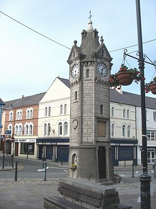
Llangefni is the county town of Anglesey in Wales and contains the principal offices of the Isle of Anglesey County Council. United Kingdom Census 2011 recorded Llangefni's population as 5,116 people, making it the second largest settlement in the county. The community includes the village of Rhosmeirch.

Aberffraw is a village and community on the south west coast of the Isle of Anglesey, in Wales, by the west bank of the Afon Ffraw. The community includes Soar and Dothan. Located near the A4080 and the nearest rail station is Bodorgan.
Pentraeth is a village and community on the island of Anglesey, North Wales, at grid reference SH523786. The Royal Mail postcode begins LL75. The community population taken at the 2011 census was 1,178. The village itself having a population of 557.

Valley is a village, community, and former electoral ward near Holyhead on the west coast of Anglesey, North Wales. The population during the 2001 census was 2,413, decreasing to 2,361 at the 2011 census.

Trearddur or Trearddur Bay is a village, seaside resort and community south of Holyhead on the west coast of Holy Island off the north-west coast of Anglesey in Wales. The community includes the small settlement of Penrhosfeilw and the Refail Farm estate.

The Isle of Anglesey County Council is the local authority for the county of Anglesey, one of the principal areas of Wales. Since 2022 the council has 35 councillors who represent 11 multi-member electoral wards.

Rhosyr is a community in the far southern corner of Anglesey, Wales. It includes the villages of Dwyran and Newborough, Llangeinwen and Llangaffo.

Bodffordd is a village and community in central Anglesey, Wales. As of the 2011 census, the community's population was 960. The community includes the hamlets of Trefor, Heneglwys and Bodwrog.

Bodorgan is a village and community on the Isle of Anglesey, Wales, United Kingdom. According to the 2001 Census, there were 1,503 residents in the now former electoral ward, 72.7% of them being able to speak Welsh. This increased to 1,704 at the 2011 Census but only 67.72% of this increased population were Welsh speakers.

Brynteg is a crossroads village and post town on the Isle of Anglesey, North Wales. It is part of the community of Llanfair-Mathafarn-Eithaf.

Llanfairpwllgwyngyll, or Llanfair Pwllgwyngyll, is a large village and local government community on the island of Anglesey, Wales, on the Menai Strait next to the Britannia Bridge and across the strait from Bangor. Both shortened and lengthened (Llanfairpwllgwyngyllgogerychwyrndrobwllllantysiliogogogoch) forms of the placename are used in various contexts.
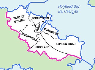
Morawelon is an area and community electoral ward in the town of Holyhead, Anglesey, Wales.

Llanfihangel Ysgeifiog is a community and former ecclesiastical parish in Anglesey, Wales, east of Llangefni.
The Isle of Anglesey electoral boundary changes in 2012 reduced the numbers of electoral wards to the Isle of Anglesey County Council from 40 to 11. This led to the postponement of local government elections in the county by 12 months. The changes were confirmed by the Isle of Anglesey Order 2012 in October 2012.

Caergybi is an electoral ward in Holyhead, Anglesey, Wales. It includes the northern half of the community including the town centre and port. Caergybi elects three county councillors to the Isle of Anglesey County Council. Caergybi includes the community wards of Town, London Road, Morawelon, Porthafelin and Parc a'r Mynydd, which elect representatives to Holyhead Town Council.
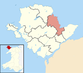
Lligwy is an electoral ward on the northeast coast of Anglesey, Wales. It includes the communities Moelfre, Llaneugrad, Llanfair-Mathafarn-Eithaf and Pentraeth; and the electoral ward of Llanfihangel Tre'r Beirdd in the community of Llanddyfnan. Lligwy elects three county councillors to the Isle of Anglesey County Council.

Canolbarth Môn is an electoral ward in the centre of Anglesey, Wales. It includes the communities of Bryngwran, Bodffordd, Llangefni, and Trewalchmai, and the majority of Llanddyfnan. Canolbarth Môn elects three county councillors to the Isle of Anglesey County Council.
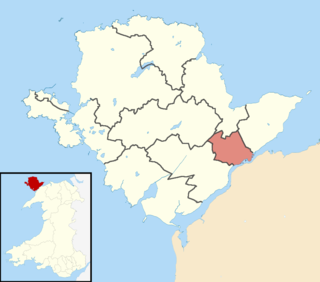
Aethwy is the name of an electoral ward in the south of Anglesey, Wales, created in 2012. It contains the population centres of Menai Bridge and Llanfair PG.
Ynys Gybi is the name of an electoral ward in the west of Anglesey, Wales, created in 2012. It covers the most part of Holy Island, whose name is Ynys Gybi in Welsh.
Parc a'r Mynydd is an area and community electoral ward in the town of Holyhead, Anglesey, Wales.
References
- ↑ "Isle of Anglesey Existing Electoral Arrangements". Local Government Boundary Commission for Wales. 11 June 2007. Archived from the original on 1 May 2007. Retrieved 24 April 2008.
- ↑ "Ward population 2011" . Retrieved 18 May 2015.
- ↑ "Isle of Anglesey (Electoral Arrangements) Order 2012" (PDF). legislation.gov.uk. The National Archives . Retrieved 2 December 2017.
- ↑ "Llanfairpwllgwyngyll Community Council Members". Llanfairpwllgwyngyll Community Council. Archived from the original on 7 February 2019. Retrieved 2 December 2017.
| | This Anglesey location article is a stub. You can help Wikipedia by expanding it. |