Upper Bavaria is one of the seven administrative regions of Bavaria, Germany.
Altötting is a Landkreis (district) in Bavaria, Germany. It is bounded by Austria and the Bavarian districts of Traunstein, Mühldorf and Rottal-Inn.

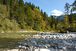
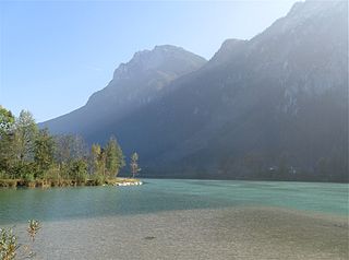
The Inn is a river in Switzerland, Austria and Germany. The 518 km (322 mi) long river is a right tributary of the Danube, being the third largest tributary of the Danube by discharge. The highest point of its drainage basin is the summit of Piz Bernina at 4,049 m (13,284 ft). The Engadine, the valley of the En, is the only Swiss valley whose waters end up in the Black Sea.
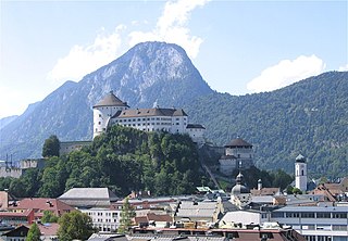
Kufstein is a town in the Austrian state of Tyrol, the administrative seat of Kufstein District. With a population of about 20,000 it is the second largest Tyrolean town after the state capital Innsbruck. The greatest landmark is Kufstein Fortress, first mentioned in the 13th century. The town was the place of origin of the Austrian noble family Kuefstein.
Mühldorf am Inn is a town in Bavaria, Germany, and the capital of the district Mühldorf on the river Inn. It is located at 48°14′30″N12°31′30″E, and had a population of about 17,808 in 2005.

The Innviertel is a traditional Austrian region southeast of the Inn river. It forms the western part of the state of Upper Austria and borders the German state of Bavaria. The Innviertel is one of the four traditional "quarters" of Upper Austria, the others being Hausruckviertel, Mühlviertel, and Traunviertel.
Josef Bauer was a German politician and a member of the Bundestag for the Christian Social Union in Bavaria from 1953 to 1969.

The Rott is a 111-kilometre-long (69 mi) river in Bavaria, Germany. It is a left tributary of the Inn. Its source is in the municipality Wurmsham in Lower Bavaria, between Landshut and Waldkraiburg. It flows east through a rural area with small towns, including Neumarkt-Sankt Veit, Eggenfelden, Pfarrkirchen and Pocking. It flows into the Inn near Neuhaus am Inn, opposite Schärding, on the border with Austria.
Schärding is a town in the northern Austrian state of Upper Austria, the capital of the district of the same name, and a major port on the Inn River. Historically, it was owned by the Wittelsbach family, which is reflected in the town's architecture.

Winhöring is a municipality in the district of Altötting in Bavaria in Germany. The river Inn forms the municipality's southern border. The smaller river Isen flows through the municipality and then into the Inn.

Flintsbach is a municipality in the district of Rosenheim in Bavaria in Germany, on the river Inn.

Griesstätt is a municipality in the district of Rosenheim in Bavaria, Germany. It lies on the river Inn.

The Lower Bavarian Upland, Lower Bavarian Hill Country or Lower Bavarian Hills, are part of the tertiary Hügelland or hill country south of the River Danube and cover much of the land within the Bavarian province of Lower Bavaria in southern Germany. To the north it is bordered by the Gäuboden region and the Bavarian Forest; to the south by Upper Bavaria, to the east by the Lower Inn Valley and to the west by the Franconian Jura. In the western part of the Lower Bavarian Hills lies the Hallertau, the world's largest hop-growing region. It belongs to two of officially defined natural regions in Germany: the eponymous Lower Bavarian hills and the Isar-Inn Gravel Beds (Isar-Inn-Schotterplatten) and is sub-divided into the Danube-Isar Hills (Donau-Isar-Hügelland) and the Isar-Inn Upland (Isar-Inn-Hügelland) with the River Isar as the boundary. The hills continue over the border into Austria as the Upper Austrian Hills.
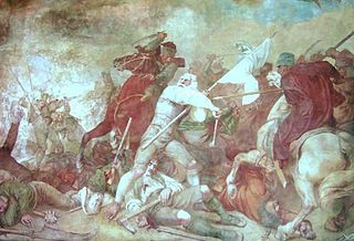
The Bavarian uprising of 1705–1706 was a revolt against the occupation of the Electorate of Bavaria by the Imperial Army of the Habsburg Monarchy during the War of the Spanish Succession (1701–1714). It lasted from early November 1705 to 18 January 1706, approximately 75 days. Henric L. Wuermeling speaks of this as "the first revolution of modern history."

Attel is a river in Bavaria, Germany. It is a left tributary of the Inn, into which it flows near Ramerberg.
Kieferbach is a river of Tyrol, Austria and Bavaria, Germany. It is a left tributary of the Inn and flows into it near Kiefersfelden.

The Rott is a river of Bavaria, Germany, and a left tributary of the Inn. The Rott springs north of the district Thann of Großkarolinenfeld. It then flows next to Großkarolinenfeld and discharges near Rott am Inn into the Inn.

Florian Pronold is a German lawyer and politician of the SPD who served as a member of the German Bundestag from 2002 until 2021. From 11 July 2009 to 20 May 2017, he was state chairman of the SPD Bavaria.

Fritz Schösser was a German politician for the Social Democratic Party (SPD). He was the chairman of the Trade Union Confederation (DGB) in Bavaria from 1990 and 2010. From 1992 to 1994, he was a member of the Bavarian Senate, after which he became a member of the Landtag of Bavaria. In 1998, Schösser was elected to the national Bundestag, serving until 2005.

The Bundesstraße 304 is a German federal highway that runs from Dachau north of Munich through the Bavarian capital via Ebersberg, Wasserburg am Inn and Traunstein to Freilassing on the border with Austria, near Salzburg.