Brandon, Nebraska | |
|---|---|
 | |
 Brandon, Nebraska  Brandon, Nebraska | |
| Coordinates: 40°48′N101°54′W / 40.8°N 101.9°W | |
| Country | |
| State | |
| County | Perkins |
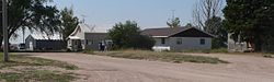
Brandon is an unincorporated community in Perkins County, Nebraska, United States. [1]
Brandon, Nebraska | |
|---|---|
| | |
| Brandon, Nebraska Brandon, Nebraska | |
| Coordinates: 40°48′N101°54′W / 40.8°N 101.9°W | |
| Country | |
| State | |
| County | Perkins |
Brandon is an unincorporated community in Perkins County, Nebraska, United States. [1]
Brandon got its start when the Burlington Railroad was extended to that point. [2] A post office called Brandon was established in 1890. [3] The origin of the name Brandon is unclear. It might be either the name of a railroad official, or named after a place in Ohio. [4]

{{cite book}}: CS1 maint: ignored ISBN errors (link) A 1925 edition is available for download at University of Nebraska—Lincoln Digital Commons. Municipalities and communities of Perkins County, Nebraska, United States | ||
|---|---|---|
| City | 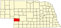 | |
| Villages | ||
| Unincorporated communities | ||
40°48′12″N101°54′45″W / 40.80333°N 101.91250°W
| | This Perkins County, Nebraska state location article is a stub. You can help Wikipedia by adding missing information. |