Brandvlei Dam

Last updated
Brandvlei Dam
Official nameBrandvlei Dam
Country South Africa
Location Western Cape
Coordinates 33°42′45″S19°24′57″E / 33.71250°S 19.41583°E / -33.71250; 19.41583 Coordinates: 33°42′45″S19°24′57″E / 33.71250°S 19.41583°E / -33.71250; 19.41583
Purpose Irrigation
Opening date1983
Owner(s) Department of Water Affairs
Dam and spillways
Type of dam Earth fill dam
Impounds Lower Brandvlei River
Reservoir
CreatesBrandvlei Dam Reservoir
Total capacity303.800.000 m3

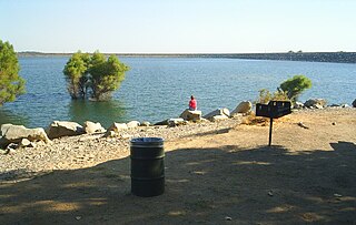
Brandvlei Dam is an earth-fill type dam on the Lower Brandvlei River in Western Cape, South Africa. It was completed in 1983 and the inlet is the Holsloot river.

Western Cape Province of South Africa on the south-western coast

The Western Cape is a province of South Africa, situated on the south-western coast of the country. It is the fourth largest of the nine provinces with an area of 129,449 square kilometres (49,981 sq mi), and the third most populous, with an estimated 6.6 million inhabitants in 2018. About two-thirds of these inhabitants live in the metropolitan area of Cape Town, which is also the provincial capital. The Western Cape was created in 1994 from part of the former Cape Province.

South Africa Republic in the southernmost part of Africa

South Africa, officially the Republic of South Africa (RSA), is the southernmost country in Africa. It is bounded to the south by 2,798 kilometres (1,739 mi) of coastline of Southern Africa stretching along the South Atlantic and Indian Oceans; to the north by the neighbouring countries of Namibia, Botswana, and Zimbabwe; and to the east and northeast by Mozambique and Eswatini (Swaziland); and it surrounds the enclaved country of Lesotho. South Africa is the largest country in Southern Africa and the 25th-largest country in the world by land area and, with over 57 million people, is the world's 24th-most populous nation. It is the southernmost country on the mainland of the Old World or the Eastern Hemisphere. About 80 percent of South Africans are of Bantu ancestry, divided among a variety of ethnic groups speaking different African languages, nine of which have official status. The remaining population consists of Africa's largest communities of European, Asian (Indian), and multiracial (Coloured) ancestry.

Contents

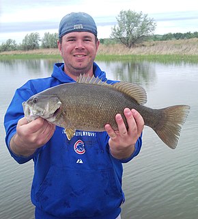
The Brandvlei Dam, 15 km south of Worcester, is often referred to as the Greater Brandvlei Dam. When both it and the adjacent Kwaggaskloof Dams are full, the “wall” as it is known that divides them is submerged, making it one massive impoundment with a capacity of 458 million cubic metres. It is reputedly the best smallmouth bass fishing area in the country. "Brandvlei" or "The Burning Marsh" was named after the regular view of steam rising from the rivulet flowing into the dam, especially during early mornings. [1]

Worcester, Western Cape Place in Western Cape, South Africa

Worcester is a town in the Western Cape, South Africa. It is located 120 kilometres (75 mi) north-east of Cape Town on the N1 highway north to Johannesburg.

Greater Brandvlei Dam is an earth-fill type dam located on a tributary of the Breede River, near Worcester, Western Cape, South Africa. It was formed by joining the original Brandvlei Dam and the Kwaggaskloof Dam after reconstruction in 1989. Its main purpose is for irrigation use and the hazard potential of the dam has been ranked high (3).

Kwaggaskloof Dam is a dam on the Wabooms River, near Worcester, Western Cape, South Africa. It was established in 1975.

Towards the northwest you will find Brandvlei Prison, which contains a hot spring with temperatures up to 45 °C, the hottest in South Africa. The Table Mountain Group hot water springs vary between 35 °C and 45 °C. The water at the nearby Goudini and the Brandvlei hot springs is classified as "pure" by virtue of its low content of dissolved mineral matter. You cannot visit this hot spring voluntarily (unfortunately it is situated inside the prison area).

Recreation

Boat launching, sailing, fishing and camping facilities are available at both Worcester Yacht club and Kwaggaskloof which make up the Greater Brandvlei dam. [2]

Water sports

The water varies from quite murky after heavy rains to clear in the summer months. Boat traffic can be heavy, it's a popular venue for water skiers, inflatable boat races are sometimes held on the dam, this can cause havoc for bass anglers. [3] The Worcester Yacht Club is situated at the Brandvlei Dam.

Angling

Kwaggaskloof (sometimes spelled Quaggaskloof) and Brandvlei Dam is considered by many to be one of the prime Smallmouth bass waters in South Africa, some would argue that it is “the” prime smallmouth lake. Regardless, the lake is certainly one that has some big smallmouth bass, until recently it was the holder of the South African record, a fish of 3.23 kg (7 lbs) caught on a crawdad coloured soft plastic worm in 4 metres (12 foot) of water in September 1998. The "wall" is an excellent spot to catch big Smallmouth Bass, fish of 2.5 to 3 kg are regularly taken along its length.

Structure is not immediately apparent on this lake but it is there, much of it is in the form of deeper ridges, channels, drop-ofs, points, old quarries and humps, a boat is a pretty much essential to fish Kwaggskloof properly and anglers need to be willing and able to read their electronics. Visible structure is there, it is just not that obvious, mainly along the South Western bank, this is also where largemouth bass are more likely to fall to a well placed spinnerbait or shallow running crankbait. Another choice piece of structure is an old road that runs into the lake in the most Southerly corner of the dam, partially exposed at low water, it's usually submerged and can easily be missed.

Largemouth bass species of fish

The largemouth bass is a carnivorous freshwater gamefish in the Centrarchidae (sunfish) family, a species of black bass native to eastern and central United States, adjacent southeastern Canada and northern Mexico, but widely introduced elsewhere. It is known by a variety of regional names, such as the widemouth bass, bigmouth bass, black bass, bucketmouth, largies, Potter's fish, Florida bass, Florida largemouth, green bass, Green trout, gilsdorf bass, Oswego bass, southern largemouth and (paradoxically) northern largemouth, LMB. The largemouth bass is the state fish of Georgia and Mississippi, and the state freshwater fish of Florida and Alabama.

See also

Related Research Articles

Smallmouth bass species of fish

The smallmouth bass is a species of freshwater fish in the sunfish family (Centrarchidae) of the order Perciformes. It is the type species of its genus. One of the black basses, it is a popular game fish sought by anglers throughout the temperate zones of North America, and has been spread by stocking—as well as illegal introductions—to many cool-water tributaries and lakes in Canada and more so introduced in the United States. The maximum recorded size is approximately 27 inches and 12 pounds. The smallmouth bass is native to the upper and middle Mississippi River basin, the Saint Lawrence River–Great Lakes system, and up into the Hudson Bay basin. Its common names include smallmouth, bronzeback, brown bass, brownie, smallie, bronze bass, and bareback bass.

Bass fishing activity of angling for the North American gamefish known colloquially as the black bass

Bass fishing is the activity of angling for the North American gamefish known colloquially as the black bass. There are numerous black bass species considered as gamefish in North America, including largemouth bass, smallmouth bass, spotted bass or Kentucky bass, and Guadalupe bass. Black bass are members of the sunfish (Centrarchidae) family.

The Little Red River is a 102-mile-long (164 km) river in White, Van Buren, Searcy, Stone and Cleburne counties of north-central Arkansas.

Vaal Dam dam on the Vaal River in South Africa

The Vaal Dam in South Africa was constructed in 1938 and lies 77 km south of OR Tambo International Airport. The lake behind the dam wall has a surface area of about 320 square kilometres (120 sq mi) and is 47 meters deep. The Vaal Dam lies on the Vaal River, which is one of South Africa's strongest-flowing rivers. Other rivers flowing into the dam are the Wilge River, Klip River, Molspruit and Grootspruit. It has over 800 kilometres (500 mi) of shoreline and is South Africa's second biggest dam by area and the fourth largest by volume.

Flaming Gorge Reservoir lake in Wyoming, United States of America

Flaming Gorge Reservoir is the largest reservoir in Wyoming, on the Green River, impounded behind the Flaming Gorge Dam. Construction on the dam began in 1958 and was completed in 1964. The reservoir stores 3,788,900 acre feet (4.6735×10⁹ m3) of water when measured at an elevation of 6,040 feet (1,841 m) above sea-level (maximum).

Lake Havasu reservoir

Lake Havasu is a large reservoir formed by Parker Dam on the Colorado River, on the border between California and Arizona. Lake Havasu City sits on the lake's eastern shore. The reservoir has an available capacity of 619,400 acre feet (764,000,000 m3). The concrete arch dam was built by the United States Bureau of Reclamation between 1934 and 1938. The lake's primary purpose is to store water for pumping into two aqueducts. Prior to the dam construction, the area was home to the Mohave Indians. The lake was named after the Mojave word for blue. In the early 19th century, it was frequented by beaver trappers. Spaniards also began to mine the areas along the river.

Amistad Reservoir reservoir on the Rio Grande at its confluence with the Devils River in Texas and Mexico

Amistad Reservoir is a reservoir on the Rio Grande at its confluence with the Devils River 12 miles (19 km) northwest of Del Rio, Texas. The lake is bounded by Val Verde County on the United States side of the international border and by the state of Coahuila on the Mexican side of the border; the American shoreline forms the Amistad National Recreation Area. The reservoir was formed in 1969 by the construction of Amistad Dam. The dam and lake are managed jointly by the governments of the United States and Mexico through the International Boundary and Water Commission. The name of the dam and lake is the Spanish word for "friendship". The reservoir is also known as Lake Amistad.

Lake Mohave is a reservoir on the Colorado River between the Hoover Dam and Davis Dam in Cottonwood Valley defining the border between Nevada and Arizona in the United States. This 67 mile stretch of the Colorado River flows past Boulder City, Nelson, Searchlight, Cottonwood Cove, Cal-Nev-Ari, and Laughlin to the west in Nevada and Willow Beach and Bullhead City to the east in Arizona. A maximum width of 4 miles wide and an elevation of 647 feet (197 m), Lake Mohave encompasses 28,260 acres of water. As Lake Mead lies to the north of the Hoover Dam, Lake Mohave and adjacent lands forming its shoreline are part of the Lake Mead National Recreation Area administered by the U.S. National Park Service.

Lake Ouachita lake in United States of America

Lake Ouachita is a reservoir created by the damming of the Ouachita River by Blakely Mountain Dam.

Folsom Lake

Folsom Lake is a reservoir on the American River in the Sierra Nevada foothills of California, United States.

Spruce Run Recreation Area

Spruce Run Recreation Area is a 1,290-acre (5.2 km2) New Jersey state recreation area located in Union Township and Clinton Township in Hunterdon County, New Jersey, United States. It encompasses the Spruce Run Reservoir that is used as a backup reservoir to protect the state from prolonged droughts. The reservoir is the third largest in the state, after Round Valley and Wanaque Reservoir. The reservoir is used for recreation purposes, including fishing, boating and swimming.

Cape whitefish species of fish

The Cape whitefish or Berg-breede River whitefish is a ray-finned fish species in the family Cyprinidae. It is placed with the South African redfins in Pseudobarbus. It is tetraploid. Its closest living relative was at one time considered the sawfin.

Bartlett Lake lake in Arizona, United States of America

Bartlett Lake is a reservoir that was formed by the damming of the Verde River in the U.S. state of Arizona. It is downstream and to the south of Horseshoe Reservoir. Constructed in 1936–39 by the Salt River Project, the Bartlett Dam and reservoir were named for Bill Bartlett, a government surveyor. Bartlett Lake was the first reservoir built on the Verde River.

Greenwood Reservoir

Greenwood Reservoir is a large, 1,073-acre (4.34 km2) impoundment located in Michigan's Upper Peninsula. It is a very picturesque and relatively secluded.

Smallmouth yellowfish species of fish

The smallmouth yellowfish is a species of ray-finned fish in the genus Labeobarbus. It has become an invasive species in rivers of the Eastern Cape, South Africa, such as the Mbhashe River.

Angostura Reservoir

Angostura Reservoir is a reservoir on the Cheyenne River in Fall River County, South Dakota, United States. It was created after the construction of Angostura Dam in 1949 for irrigation by the U.S. Bureau of Reclamation. "Angostura" means "narrows" in Spanish.

Lake Zoar

Lake Zoar is a reservoir on the Housatonic River in the U.S. state of Connecticut. It is formed by Stevenson Dam. The towns of Monroe, Newtown, Oxford, and Southbury border Lake Zoar.

There are three Manistique Lakes in the Upper Peninsula of Michigan. The lakes include North Manistique Lake, Big Manistique Lake, and South Manistique Lake. The towns surrounding the lakes are Curtis Township, Germfask, and Helmer. The lakes are known for vacationing and fishing. They are also in close proximity to other natural sights such as the Great Lakes, rivers, and smaller lakes as well as tourist attractions including the Canada–US border, the Soo Locks, Mackinac Island, parks, and museums.

Willow Springs Lake Lake in Coconino County, Arizona, U.S.


Willow Springs Lake is a cold water lake located on top of the Mogollon Rim in northern Arizona, about 23 mi (37 km) east of the city of Payson in the Apache-Sitgreaves National Forests, immediately adjacent to SR 260. It is a canyon-bound lake located on the Mogollon Rim, and is part of the collectivity known as the Rim Lakes. It can be found upstream from Chevelon Canyon Lake. The facilities are maintained by Apache-Sitgreaves National Forests division of the USDA Forest Service.

References

  1. "Archived copy". Archived from the original on 2014-05-23. Retrieved 2014-05-23.CS1 maint: Archived copy as title (link)
  2. http://tracks4africa.co.za/listings/item/w126940/brandvlei-dam/
  3. "Archived copy". Archived from the original on 2014-05-23. Retrieved 2014-05-22.CS1 maint: Archived copy as title (link)