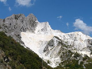
A quarry is a type of open-pit mine in which dimension stone, rock, construction aggregate, riprap, sand, gravel, or slate is excavated from the ground.

Interstate Park comprises two adjacent state parks on the Minnesota–Wisconsin border, both named Interstate State Park. They straddle the Dalles of the St. Croix River, a deep basalt gorge with glacial potholes and other rock formations. The Wisconsin park is 1,330 acres (538 ha) and the Minnesota park is 298 acres (121 ha). The towns of Taylors Falls, Minnesota and St. Croix Falls, Wisconsin are adjacent to the park. Interstate Park is within the Saint Croix National Scenic Riverway and the Ice Age National Scientific Reserve. The western terminus of the Ice Age National Scenic Trail is on the Wisconsin side. On the Minnesota side, two areas contain National Park Service rustic style buildings and structures that are listed on the National Register of Historic Places.

Bald Mountain State Recreation Area is a 4,637-acre (1,877 ha) state park located near Lake Orion, Michigan off M-24. It consists of some of the most rugged terrain in southeastern Michigan. The recreation area is composed of a North Unit and a South Unit, which are not contiguous. The South Unit itself includes two parts separated by M-24, but the section west of M-24 has no recreational facilities or trails and is primarily undeveloped forest and grassy plains segmented by a few through-roads.
Raccoon Creek State Park is a 7,572-acre (3,064 ha) Pennsylvania state park on Raccoon Creek in Hanover and Independence townships in Beaver County, Pennsylvania in the United States. The park is about 30 miles (48 km) from the city of Pittsburgh, near Hookstown. Raccoon Creek State Park is easily accessed from Pennsylvania Route 18 and U.S Routes 30 and 22. The park offers numerous activities such as hiking, biking, cross-country skiing, camping, swimming, fishing, and boating, the last three at the 101-acre (41 ha) "Raccoon Lake."

The Church of the Holy Trinity is an historic Episcopal church at 381 Main Street in Middletown, Connecticut. Completed in 1874, it is one of the city's finest examples of Gothic Revival architecture. Its nearby former rectory, also known as the Bishop Acheson House, is one of its finest Colonial Revival houses. The two buildings were listed on the National Register of Historic Places in 1979.

Quarry Lakes Regional Recreation Area is a regional park located in Fremont, California that is part of the East Bay Regional Parks system. Before being converted into a park, the site was used as a gravel quarry. When water purchased by the public for groundwater recharge of the Niles Cone flooded the gravel pits, the gravel harvesters began to daily pump the seeping water down Alameda Creek into San Francisco Bay. The Alameda County Water District acquired the quarry after the pumping was declared to be an illegal waste in 1976.

Backbone State Park is Iowa's oldest state park, dedicated in 1919. Located in the valley of the Maquoketa River, it is approximately three miles (5 km) south of Strawberry Point in Delaware County. It is named for a narrow and steep ridge of bedrock carved by a loop of the Maquoketa River originally known as the Devil's Backbone. The initial 1,200 acres (490 ha) were donated by E.M. Carr of Lamont, Iowa. Backbone Lake Dam, a relatively low dam built by the Civilian Conservation Corps (CCC) in the 1930s, created Backbone Lake. The CCC constructed a majority of trails and buildings which make up the park.

Lake of the Ozarks State Park is a Missouri state park on the Grand Glaize Arm of the Lake of the Ozarks and is the largest state park in the state. This is also the most popular state park in Missouri, with over 2.5 million visitations in 2017.

The Menlo Avenue–West Twenty-ninth Street Historic District is a historic district in the North University Park neighborhood of Los Angeles, which is itself part of the city's West Adams district. The area consists of late Victorian and Craftsman-style homes dating back to 1896. The area is bounded by West Adams Boulevard on the north, Ellendale on the east, West Thirtieth Street on the south, and Vermont Avenue to the west. The district is noted for its well-preserved period architecture, reflecting the transition from late Victorian and shingle-styles to the American Craftsman style that took hold in Southern California in the early 1900s. The district was added to the National Register of Historic Places in 1987.

The Bank Lofts is a building in Denver, Colorado. Constructed in 1921, the building is listed on the National Register of Historic Places.
This is a list of the properties and historic districts in Stamford, Connecticut that are listed on the National Register of Historic Places. The locations of National Register properties and districts for which the latitude and longitude coordinates are included below, may be seen in a Google map.
This is a list of the National Register of Historic Places listings in Southington, Connecticut.

Lake Ahquabi State Park is a state park of Iowa, US, featuring a 115-acre (47 ha) reservoir. Ahquabi means "resting place" in the Fox language. The park is 6 miles (9.7 km) south of Indianola and 22 miles (35 km) south of Des Moines. Three section of the park were listed on the National Register of Historic Places in 1991.
This is a complete list of the properties and districts on the National Register of Historic Places in Rocky Mountain National Park, Colorado, United States. The locations of National Register properties and districts for which the latitude and longitude coordinates are included below, may be seen in a Google map.
The National Register Information System (NRIS) is a database of properties that have been listed on the United States National Register of Historic Places. The database includes more than 84,000 entries of historic sites that are currently listed on the National Register, that were previously listed and later removed, or that are pending listing. The database includes approximately 45 pieces of data for each listed property. Accuracy of the NRIS database may be imperfect. For example, a 2004 paper addressed accuracy of spatial location data for part of the NRIS content.

Orange Springs is a historic 52-acre home, farm complex, and former resort spa located near Unionville, Orange County, Virginia, just east of the intersection of US Route 522 and Route 629, located along Route 629, overlooking Terry's Run.

Lindley-Johnson-Vanderhoof House is a three-story Queen Anne style brick house designed and built by William G. Fraser in 1892. The house is located in downtown Colorado Springs, Colorado and was used as a private residence from 1892 until 2000, when the Colorado College purchased the property. The house was listed on the National Register of Historic Places in 2013.
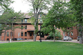
The McGregor Hall is a historic building designed by Walter F. Douglas and Thomas Duncan Hetherington and built in 1903. The building is located on the grounds of the Colorado College in Colorado Springs, Colorado. The building was the third dormitory for women on the Colorado College campus.
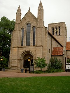
The Shove Memorial Chapel is a church located in downtown Colorado Springs, Colorado that was designed by John Grey and built from 1930 to 1931. The church has been on the National Register of Historic Places since May 22, 2005, and is of Norman Romanesque style.

The Harris Park School is a school building in Westminster, Colorado that was built from 1892-1899. The building was originally Romanesque Revival in architecture style, but was remodeled in the 1920’s to incorporate the Craftsman style.


