
New Jalpaiguri Junction Railway Station(Station code: NJP) is a railway station which serves the twin cities of Siliguri and Jalpaiguri, the largest metropolis of North Bengal. New Jalpaiguri, as a railway station serves as the entry point to Nepal, Sikkim, Bhutan, Bangladesh and the seven northeastern states. The railway station is the largest as well as the most busiest railway junction of North East Frontier Zone, which serves as the lifeline of the Northeastern states. NJP acts as a connecting base for the Northeastern states to the Indian mainland.

Line 3 is a north-south line of the Shanghai Metro network. Its rolling stock carry a bright yellow colour belt to differentiate them from Line 4 trains which share a portion of its route. Unlike the majority of the lines in the Shanghai Metro system, Line 3 is primarily elevated, entirely above ground except for Tieli Road, located at the entrance to Baosteel Group Corporation. The line runs from North Jiangyang Road in the north to Shanghai South Railway Station in the southwest of the city, where it meets Line 1. While Line 1 goes straight through the city center, Line 3 roughly follows the Inner Ring Road around the city from Caoxi Road to Zhongtan Road. The line is colored yellow on system maps.

Chinchani is a census town in Palghar district in the state of Maharashtra, India.

The Kangra Valley Railway lies in the sub-Himalayan region of Kangra Valley and covers a distance of 164 km (101.9 mi) from Pathankot, Punjab to Jogindernagar in Himachal Pradesh, India. The Kangra valley railway comes under the Firozpur division of Northern Railway.
Vasai–Virar is a city and tehsil (subdistrict) in Konkan division of Maharashtra state in western India, comprising the most populated part of Palghar district and is also a part of Mumbai Metropolitan Region (MMR).According to the 2011 census, it is the fifth largest city in Maharashtra. It is located in Palghar district, 50+ km north of Mumbai. The city is located on the north bank of Vasai Creek, part of the estuary of the Ulhas River. Vasai–Virar City Municipal Corporation (VVMC) covers the tehsil.

Avarolli is a village in Belgaum district in the southern state of Karnataka, India.
Jhang Sadar Railway Station Phone Number is

Bolan Mail is a passenger train operated daily by Pakistan Railways between Karachi and Quetta. The trip takes approximately 20 hours and 50 minutes to cover a published distance of 857 kilometres (533 mi), traveling along a stretch of the Karachi–Peshawar Railway Line, Kotri–Attock Railway Line and Rohri–Chaman Railway Line. The train is named after the famous Bolan Pass, a strategically located pass connecting to Central Asia.

Malda Town is a railway station, serves Malda city in Malda district in the Indian state of West Bengal. It is the rail head for a visit to Gour and Pandua or notable place Adina Mosque and Adina Deer Park.
Landi Kotal railway station was a railway station in Landi Kotal, a town in the Federally Administered Tribal Areas of Pakistan. It lies near the border with the Nangarhar Province of Afghanistan. The railway station was built in 1925 during British rule. It was the terminus railway station of Khyber Pass Railway.

Bandhi railway station is located in Bandhi town, Shaheed Benazir Abad district, Sindh province, Pakistan.
Braudabad railway station is located in Braudabad village, Thatta district of Sindh province, Pakistan.
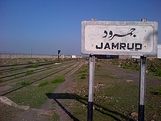
Jamrud Junction railway station is a railway station in Jamrud, a town in the Khyber Agency, within Khyber Pakhtunkhwa, Pakistan.
Kiamari Railway Station is located in Kiamari Town, Karachi, Sindh, Pakistan.۔
Sarhari railway station is located in Sarhari town, Sanghar district, Sindh, Pakistan.

Shela Bagh railway station is located in Shela Bagh town, Qilla Abdullah district of Balochistan province of the Pakistan.

Mysore–Chamarajanagar branch line is an Indian railway line from Mysore Junction to Chamarajanagar.
Karachi–Peshawar Railway Line is one of four main railway lines in Pakistan, operated and maintained by Pakistan Railways. The line begins from Karachi City station or Kiamari station and ends at Peshawar Cantonment Station. The total length of this railway line is 1,687 kilometers (1,048 mi). There are 184 railway stations from Kiamari to Peshawar Cantonment on this line. The line serves as the main passenger and freight line of the country. 75% of the country’s cargo and passenger traffic uses the line. The line is currently undergoing an six-year ₨886.68 billion (US$8.4 billion) upgrade and renovation as part of the China Pakistan Economic Corridor, with average rail speeds expected be doubled to 160 kilometers per hour upon completion.
Dargai railway station is located in town of Dargai in Malakand District, Khyber Pakhtunkhwa province, Pakistan. The station is the last station on Nowshera–Dargai Branch Line. The station was closed in 2002 and Railway land was leased to avoid unauthorized occupation and encroachments.


