Breitenbach may refer to:

The Lost River Range is a high mountain range of the Rocky Mountains, located in central Idaho, in the northwestern United States.

The Echaz is a 23km long river in Baden-Württemberg, Germany, a tributary of the Neckar.

Breitenbach am Herzberg is a community in southwesternmost Hersfeld-Rotenburg district in eastern Hesse, Germany.
Breitenbach am Inn is a municipality in the Kufstein district in the Austrian state of Tyrol located 5.5 km west of Wörgl and 19 km southwest of Kufstein. The village has five parts and received new parts and house numbers in 2006. It was founded in the middle of the 19th century.

Breitenbach-Haut-Rhin is a commune in the Haut-Rhin department in Grand Est in north-eastern France.

The Speyerbach is a left tributary of the Rhine in the Palatinate part of Rhineland-Palatinate. In Speyer, the river split into Gießhübelbach and Woogbach. The Woogbach changes its name to Nonnenbach, then flows into Gießhübelbach shortly before the latter flows into the Rhine.

The Rehbach is a river in Rhineland-Palatinate. It is about 29 kilometres (18 mi) long and is a left tributary of the Rhine.

The Mußbach is a stream, nearly 12 kilometres (7.5 mi) long, in the eastern Palatinate Forest and in the Anterior Palatinate region in the south of German state of Rhineland-Palatinate. The former village of Mußbach was named after it.

The Hochspeyerbach is a 21 km (13 mi) long river in the Palatinate forest in Rhineland-Palatinate and a left tributary of the Speyerbach.

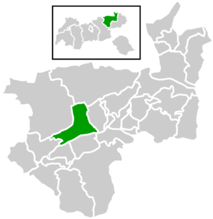
The Breitenbach in Baden-Württemberg, Landkreis Reutlingen, is a southern and orographic left tributary of the Echaz. It is about 8.9 kilometres (5.5 mi) long. It is a southern and left tributary of the Echaz, which is located in Reutlingen..
The Erlenbach (help·info) is a river in the Palatinate Forest, in the (Palatinate region of Rhineland-Palatinate. It is the strongest headwater of the Speyerbach, which is the largest river in the Anterior Palatinate.

Mount Breitenbach, at 12,140 feet (3,700 m) above sea level, is the fifth-highest peak in the U.S. state of Idaho and the fourth-highest in the Lost River Range. The peak is located in Salmon-Challis National Forest in Custer County. It is 2.0 miles (3.2 km) east of Mount Church, its line parent, 1.4 miles (2.3 km) east of Donaldson Peak, 0.85 miles (1.37 km) southeast of No Regret Peak, and 1.8 miles (2.9 km) north of Lost River Peak.
The Helmbach is an 11 km (6.8 mi) long tributary of the Speyerbach stream in the Palatine Forest in the German state of Rhineland-Palatinate.

The Frankenweide is a hill region in the German state of Rhineland-Palatinate. It forms the central part of the Palatine Forest in the Palatinate region.

Walking routes in the Palatine Forest fall into two categories. The first are longer walking routes, most of which are maintained by the Palatine Forest Club, or PWV, and which are linked to the national and international network of long distance paths. The second category are those local circular walks and themed walking routes, some of which are of wider regional importance, and which are maintained by municipal authorities. The Palatine Forest, as part of the Palatine Forest-North Vosges Biosphere Reserve, is an important conservation area. As a result, the Palatine Forest, the bunter sandstone landscape of the Palatine Forest Nature Park, the castles in the Dahner Felsenland and the cross-border paths into Alsace and the Vosges make the region particularly popular with ramblers and walkers.
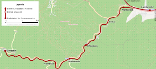
The Cuckoo Railway, in its early days the Elmstein Valley Railway, is a 12.97 kilometre long branch line in the central Palatine Forest, which runs through the region of Neustadt/Kaiserslautern from Lambrecht to Elmstein. It was built primarily to support the local forestry industry.
The Elmstein valley runs through the central Palatine Forest region between the villages of Frankeneck and Johanniskreuz in the German state of Rhineland-Palatinate. The Speyerbach stream, a left tributary of the Rhine, flows through the valley.

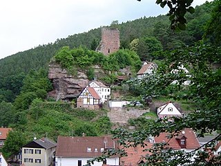
The ruins of Breitenstein Castle stand on a crag, 220 metres (720 ft) high, on the northern side of the Speyerbach valley in the Palatine Forest in Germany. The castles is 4 kilometres (2.5 mi) east of the village of Elmstein in the county of Bad Durkheim in the state of Rhineland-Palatinate.
