The Great Salt Lake is the largest saltwater lake in the Western Hemisphere and the eighth-largest terminal lake in the world. It lies in the northern part of the U.S. state of Utah and has a substantial impact upon the local climate, particularly through lake-effect snow. It is a remnant of Lake Bonneville, a prehistoric body of water that covered much of western Utah.

Galway Bay is a bay on the west coast of Ireland, between County Galway in the province of Connacht to the north and the Burren in County Clare in the province of Munster to the south; Galway city is on the northeast side. The bay is about 50 kilometres (30 mi) long and from 10 kilometres (6 mi) to 30 kilometres (20 mi) in breadth. The Aran Islands are to the west across the entrance and there are numerous small islands within the bay. To the west of Galway, the rocks are granite but to the south they are limestone.
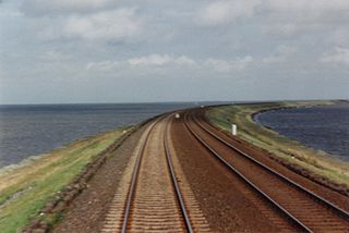
A causeway is a track, road or railway on the upper point of an embankment across "a low, or wet place, or piece of water". It can be constructed of earth, masonry, wood, or concrete. One of the earliest known wooden causeways is the Sweet Track in the Somerset Levels, England, which dates from the Neolithic age. Timber causeways may also be described as both boardwalks and bridges.

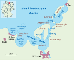
Poel or Poel Island, is an island in the Baltic Sea. It forms the natural northern and eastern boundaries of the Bay of Wismar on the German coast. The northern coast of the island is also on the south side of the large gulf known as the Bay of Mecklenburg, which Wismar Bay enters into. Insel Poel thus forms on its northern side the unofficial latitude of the northern boundary of the Wismar Bay.

The Frisian Islands, also known as the Wadden Islands or the Wadden Sea Islands, form an archipelago at the eastern edge of the North Sea in northwestern Europe, stretching from the northwest of the Netherlands through Germany to the west of Denmark. The islands shield the mudflat region of the Wadden Sea from the North Sea.

Biscayne Bay is a lagoon with characteristics of an estuary located on the Atlantic coast of South Florida. The northern end of the lagoon is surrounded by the densely developed heart of the Miami metropolitan area while the southern end is largely undeveloped with a large portion of the lagoon included in Biscayne National Park.

Hecate Strait is a wide but shallow strait between Haida Gwaii and the mainland of British Columbia, Canada. It merges with Queen Charlotte Sound to the south and Dixon Entrance to the north. About 140 kilometres (87 mi) wide at its southern end, Hecate Strait narrows in the north to about 48 kilometres (30 mi). It is about 260 kilometres (160 mi) in length.
Plum Island is a barrier island located off the northeast coast of Massachusetts, north of Cape Ann, in the United States. It is approximately 11 miles (18 km) in length. The island is named for the wild beach plum shrubs that grow on its dunes, but is also famous for the purple sands at high tide, which get their color from tiny crystals of pink pyrope garnet. It is located in parts of four municipalities in Essex County. From north to south they are the city of Newburyport, and the towns of Newbury, Rowley, and Ipswich.

Mandø is one of the Danish Wadden Sea islands off the southwest coast of Jutland, Denmark in the Wadden Sea, part of the North Sea. The island covers an area of 7.63 square kilometres and had 40 inhabitants in January 2018. The island is part of Esbjerg Municipality and is situated approximately 12 kilometres southwest of the ancient town of Ribe.

The intertidal zone, also known as the foreshore, is the area above water level at low tide and underwater at high tide. This area can include several types of habitats with various species of life, such as seastars, sea urchins, and many species of coral with regional differences in biodiversity. Sometimes it is referred to as the littoral zone or seashore, although those can be defined as a wider region.

Walfisch is an uninhabited German island, in the Bay of Mecklenburg in the Baltic Sea. It lies approximately 4.5 kilometres (2.8 mi) north of the city of Wismar, south of the island of Poel. The very flat island has a maximum circumference of about 500 by 300 metres, a surface area of 20 hectares and is a nature reserve.
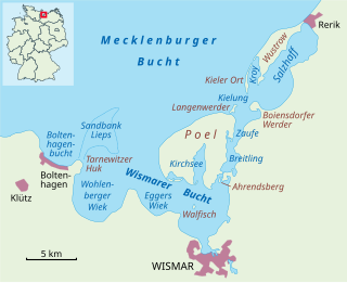
The Bay of Wismar or more commonly Wismar Bay or Wismarbucht is a well sheltered multi-sectioned bay in the southwestern Baltic Sea, in Mecklenburg-Vorpommern, Germany, and is considered the south-central part of the much larger arm of the Baltic known as the Mecklenburg Bay —a long fingerlike gulf oriented to the west-southwest (WSW) from the (central) Baltic proper. Wismar bay is considered one of the finest natural harbors on the Baltic, and served as the destination for much seaborne shipping until circa the 1910s when its minimum depths of 5 meters (16 ft) became too shallow for larger more modern ships. Today, because of the shallow sheltered waters the bay is the subject of much research via underwater archeology

Chepiwanoxet is a neighborhood in Warwick, Rhode Island, with an island peninsula in Greenwich Bay, an arm of Narragansett Bay. The neighborhood straddles the Amtrak railroad lines, which lies just east of and parallel to the Post Road. Its boundaries are Neptune Street to the North, Alger Avenue to the South, Post Road to the West, and Greenwich Bay to the East. Chepiwanoxet Way, an underpass beneath the Amtrak lines, now serves as the only street access in and out of the neighborhood.

The Laguna Madre is a long, shallow, hypersaline lagoon along the western coast of the Gulf of Mexico in Nueces, Kenedy, Kleberg, Willacy and Cameron Counties in Texas, United States. It is one of seven major estuaries along the Gulf Coast of Texas. The roughly 20-mile (32 km) long Saltillo Flats land bridge divides it into Upper and Lower lagoons joined by the Intracoastal Waterway, which has been dredged through the lagoon. Cumulatively, Laguna Madre is approximately 130 miles (210 km) long, the length of Padre Island in the US. The main extensions include Baffin Bay in Upper Laguna Madre, Red Fish Bay just below the Saltillo Flats, and South Bay near the Mexican border. As a natural ecological unit, the Laguna Madre of the United States is the northern half of the ecosystem as a whole, which extends into Tamaulipas, Mexico approximately 144 miles (232 km) south of the US border, to the vicinity of the Rio Soto La Marina and the town of La Pesca, extending approximately 275 miles (443 km) through USA and Mexico in total.
Eggers Wiek is a sickle-shaped bay within the Bay of Wismar on the southwestern Baltic Sea coast of the German state of Mecklenburg. Its stretch of beach lies about six kilometres northwest of the Hanseatic town of Wismar and is about five kilometres long. The coast here is steep in places with sea cliffs up to 11 m above sea level (NN), but in the middle it also has flat, sandy beaches. Opposite the Wiek lies the island of Poel, about 3.5 kilometres away. Eggers Wiek is bordered to the northwest by the stony cape of the Hohe Wieschendorfer Huk. West of this hook, the larger bay of Wohlenberger Wiek opens up. The coastal section of Eggers Wiek belongs to the parishes of Hohenkirchen and Zierow in the district of Nordwestmecklenburg. In Hohes Wieschendorf in the municipality of Hohenkirchen, the landing stage has been expanded into a marina which, along with a golf course on the cape, contributes to the development of tourism in the area.
The Salzhaff is a part of the Bay of Wismar that is almost cut off from the Baltic Sea by the spit of the Wustrow and Boiensdorfer Werder peninsulas. It is located south of the town of Rerik in Mecklenburg-Vorpommern and southwest of the seaside resort of Kühlungsborn in Central Mecklenburg. It is linked to the Bay of Wismar by the Breitling.

Ahrendsberg is an uninhabited island, 8.6 hectares in area, near the island of Poel in the Breitling, a strait off the Bay of Wismar on the Baltic coast of Germany.

The Obersee is the smaller of the two parts of Zürichsee in the cantons of St. Gallen and Schwyz in Switzerland.