Grong (help·info) is a municipality in Trøndelag county, Norway. It is part of the Namdalen region. The administrative centre of the municipality is the village of Medjå. Other villages in the municipality include Bergsmoen, Formofoss, Gartland, and Harran.

Namsen (Norwegian) or Nååmesje (Southern Sami) is one of the longest rivers in Trøndelag county, in the central part of Norway. The 228-kilometre (142 mi) long river flows through the municipalities of Røyrvik, Namsskogan, Grong, Overhalla, and Namsos before emptying into the Namsenfjorden. The river is the namesake for the whole Namdalen region. The river traditionally has been used for floating timber down from the forests to the town of Namsos, where the sawmills were located. Today, parts of the Namsen are regulated by several dams.

Verdalsøra is a town in the municipality of Verdal in Trøndelag county, Norway. The town is the administrative center of the municipality. It is located along the Trondheimsfjord at the mouth of the river Verdalselva. The village of Vinne lies 4 kilometres (2.5 mi) to the southeast, Trones lies about 5 kilometres (3.1 mi) to the north, the villages of Forbregd/Lein lie about 4 kilometres (2.5 mi) to the northeast, and the village of Stiklestad lies about 3 kilometres (1.9 mi) to the east. In 1998, the municipal council of Verdal voted to grant the urban area of Verdalsøra town status under the laws of Norway.
Kalvvatnet (Norwegian) or Gaejsienjaevrie (Southern Sami) is a lake in Norway that lies in Namsskogan municipality in Trøndelag county and Bindal municipality in Nordland county. Most of the 2.65-square-kilometre (1.02 sq mi) lake is in Bindal, about 15 kilometres (9.3 mi) northwest of the village of Namsskogan.
Mellingsvatnet (Norwegian) or Veelnjesjaevrie (Southern Sami) is a 4.47-square-kilometre (1.73 sq mi) lake in Norway. The lake lies in the municipalities of Namsskogan and Grane. The lake lies about 1.5 kilometres (0.93 mi) west of the European route E6 highway on the border of the two municipalities.
Sørungen is a lake in the municipality of Selbu in Trøndelag county, Norway. The 7.24-square-kilometre (2.80 sq mi) lake is located about 8 kilometres (5.0 mi) south of the village of Vikvarvet, about 18 kilometres (11 mi) west of the village of Flora, and about 10 kilometres (6.2 mi) northeast of the lake Samsjøen in the neighboring municipality of Midtre Gauldal.
Tunnsjøflyan is a lake in the municipality of Røyrvik in Trøndelag county, Norway. The 7.12-square-kilometre (2.75 sq mi) lake drains out into the large lake Tunnsjøen to the east.
Storvatnet is a lake in the municipality of Indre Fosen in Trøndelag county, Norway. The 15.78 square kilometres (6.09 sq mi) lake is located about 10 kilometres (6.2 mi) east of the village of Årnset and about 5 kilometres (3.1 mi) north of the village of Vanvikan. It is the largest lake on the Fosen peninsula.
Havdalsvatnet (Norwegian) or Haavhtere (Southern Sami) is a lake in the municipality of Lierne in Trøndelag county, Norway. The 8.12-square-kilometre (3.14 sq mi) lake lies in the northern part of the municipality, just south of the large lake Tunnsjøen. The village of Tunnsjø senter lies about 14 kilometres (8.7 mi) east of the lake and the lake Skorovatn lies about 8 kilometres (5.0 mi) to the west.
Storfrøyningen or Frøyningen (Norwegian), also known as Freavnanjaevrie or Stoerre Freavnanjaevrie (Southern Sami), is a lake in the municipality of Namsskogan in Trøndelag county, Norway. The 2.72-square-kilometre (1.05 sq mi) lake lies about 700 metres (2,300 ft) west of the European route E6 highway and the river Namsen, about 5 kilometres (3.1 mi) north of the village of Namsskogan.
Storgrønningen is a lake in the municipality of Høylandet in Trøndelag county, Norway. The extreme southern tip of the lake crosses over the border into Overhalla municipality. The lake lies about 7.5 kilometres (4.7 mi) west of the village of Høylandet and about 4 kilometres (2.5 mi) southeast of the mountain Grønningfjella.
Storgåsvatnet (Norwegian) or Stoerrereetjke (Southern Sami) is a lake in the municipality of Namsskogan in Trøndelag county, Norway. The 2.8-square-kilometre (1.1 sq mi) lake lies in the northern part of the municipality, southwest of the lake Mellingsvatnet and 4 kilometres (2.5 mi) west of the European route E6 highway. It is near Børgefjell National Park.
Skorovatn is a village in the municipality of Namsskogan in Trøndelag county, Norway. The old Skorovas Gruber mine is here, but it closed in 1984. Skorovatn is located right on the border with the municipality of Røyrvik, just south of the lake Tunnsjøflyan and the large lake Tunnsjøen. Skorovatn is about 20 kilometres (12 mi) east of the main European route E6 highway that crosses Namsskogan. Skorovatn Chapel is located in the village.
Trones is a village in the municipality of Namsskogan in Trøndelag county, Norway. It is located along the river Namsen about 30 kilometres (19 mi) south of the village of Namsskogan and about 15 kilometres (9.3 mi) south of the village of Brekkvasselv. The village of Skorovatn is located about 30 kilometres (19 mi) to the southeast. Trones Church is located in Trones, and it is the main church for the area. European route E6 highway and the Nordlandsbanen railway line both pass through the village.
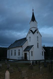
Trones Church is a parish church of the Church of Norway in Namsskogan municipality in Trøndelag county, Norway. It is located in the village of Trones. It is the main church for the Namsskogan parish which is part of the Namdal prosti (deanery) in the Diocese of Nidaros. The white, wooden church was built in a long church style in 1832 by the architect Ole Scheistrøen. The church seats about 150 people.

Bjørhusdal Church is a parish church of the Church of Norway in Namsskogan municipality in Trøndelag county, Norway. It is located in the countryside about 3 kilometres (1.9 mi) west of the village of Namsskogan. It is one of the three churches for the Namsskogan parish which is part of the Namdal prosti (deanery) in the Diocese of Nidaros. The brown, wooden church was built in a long church style in 1970 by the architect Arne Aursand. The church seats about 120 people and it serves the northern part of the municipality.

Skorovatn Chapel is a parish church of the Church of Norway in Namsskogan municipality in Trøndelag county, Norway. It is located in the old mining village of Skorovatn. It is one of three churches for the Namsskogan parish which is part of the Namdal prosti (deanery) in the Diocese of Nidaros. The brown, wooden church with a red roof was built in a long church style in 1965 by the architect Arne Aursand. The church seats about 170 people.

Harran is a former municipality in the old Nord-Trøndelag county, Norway. The municipality existed from 1923 until its dissolution in 1964. The municipality was located in the Namdalen valley and it included all of what is now the northern part of the municipality of Grong in Trøndelag county. The administrative centre was the village of Harran where the Harran Church is located.
Namsskogan is the administrative centre of Namsskogan municipality in Trøndelag county, Norway. The village is located in the Namdalen valley on an island in the middle of the river Namsen, although it also includes land on both sides of the river. The European route E06 highway and the Nordlandsbanen railway line both run through the village, with the train stopping at Namsskogan Station. The village of Brekkvasselv lies about 12 kilometres (7.5 mi) to the south. Bjørhusdal Church is located about 4 kilometres (2.5 mi) west of the village.