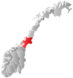
Grong (help·info) is a municipality in Trøndelag county, Norway. It is part of the Namdalen region. The administrative centre of the municipality is the village of Medjå. Other villages in the municipality include Bergsmoen, Formofoss, Gartland, and Harran.

Langørjan or Rye is a village in the municipality of Trondheim in Trøndelag county, Norway. The village is located in the borough of Heimdal in the Byneset district about 12 kilometres (7.5 mi) west of the city of Trondheim and about 7.5 kilometres (4.7 mi) north of the village of Spongdal.
Ringvål is a village in the municipality of Trondheim in Trøndelag county, Norway. The village is located in the borough of Heimdal, at the mouth of the Gaula River between the urban areas of Heimdal and Spongdal.
Storvatnet is a lake in the municipality of Indre Fosen in Trøndelag county, Norway. The 15.78 square kilometres (6.09 sq mi) lake is located about 10 kilometres (6.2 mi) east of the village of Årnset and about 5 kilometres (3.1 mi) north of the village of Vanvikan. It is the largest lake on the Fosen peninsula.

Lauvsnes is the administrative centre of the municipality of Flatanger in Trøndelag county, Norway. The village is located along the shore, about 15 kilometres (9.3 mi) northeast of the village of Vik. Lauvsnes has some small industry as well as fish farming. The island of Løvøya lies just north of the village.
Spongdal is a village in the municipality of Trondheim in Trøndelag county, Norway. It is the largest village in the Byneset area in Heimdal borough. It is located between the villages of Langørjan and Ringvål. The Byneset Church lies about 2.5 kilometres (1.6 mi) west of the village of Spongdal.

Sparbu is a village in the municipality of Steinkjer in Trøndelag county, Norway. The village is located about 12 kilometres (7.5 mi) south of the town of Steinkjer. The European route E6 highway runs through the village as does the Nordlandsbanen railway line which stops at the Sparbu Station. The village of Mære lies about 2 kilometres (1.2 mi) to the north, the village of Røra lies about 8 kilometres (5.0 mi) to the south, and the lake Leksdalsvatnet lies about 8 kilometres (5.0 mi) to the east.
Namsvatnet (Norwegian) or Nååmesjenjaevrie (Southern Sami) is a 39.38-square-kilometre (15.20 sq mi) lake in the municipality of Røyrvik in Trøndelag county, Norway. The river Namsen used to be the primary outlet, but the lake has been regulated for hydroelectric generation since 1959 and part of the water is diverted south towards a power station. The lake is fed by three main sources within Børgefjell National Park: the river Storelva which comes from the lake Jengelvatnet, the river Virmaelva, and the river Orelva which comes from the lake Ovrejaevrie. Namsvatnet has Arctic char, trout, and small carp. Today, tourism is an important activity.
Spillum is a village in the municipality of Namsos in Trøndelag county, Norway. The village is located along the south side of the Namsen river about 5 kilometres (3.1 mi) directly south of the centre of the town of Namsos and about 4 kilometres (2.5 mi) north of the village of Klinga. The Norwegian Sawmill Museum is located in the village of Spillum.
Brekkvasselv is a village in the municipality of Namsskogan in Trøndelag county, Norway. It is located along the river Namsen about 10 kilometres (6.2 mi) southwest of the village of Namsskogan and about 15 kilometres (9.3 mi) northeast of Trones. The village sits at the intersection of European Route E6 and Norwegian County Road 773 which heads east towards Røyrvik municipality. The Nordlandsbanen railway line also runs through the village, stopping at Brekkvasselv Station. The village had 141 residents in 2012.
Midtbygda or Meråker is the administrative centre of the municipality of Meråker in Trøndelag county, Norway. Midtbygda is located along the Stjørdalselva river and the European route E14 highway. It is served by Meråker Station, which is a railway station located along the Meråker Line. The local Meråker Church lies about 2 kilometres (1.2 mi) west of the village of Midtbygda. The lake Funnsjøen lies about 6 kilometres (3.7 mi) to the north.
Ottersøya is a village in Nærøy municipality in Trøndelag county, Norway. The village is located at the southwestern end of the Kvingra peninsula, just across the Nærøysundet from the village of Rørvik. It is much closer to Rørvik than to its own municipal centre, Kolvereid. The village of Torstad lies about 6 kilometres (3.7 mi) north of Ottersøya. The Marøysund Bridge and Nærøysund Bridge lie just south of Ottersøya.
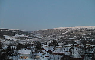
Medjå or Grong is a village which serves as the administrative center of the municipality of Grong in Trøndelag county, Norway. It is located along the river Namsen, at the confluence with the river Sanddøla. The Nordland Line runs along the eastern part of the village, stopping at Grong Station. The European route E6 highway runs through the western edge of the village. Grong Church, the main church for the area, is also located in this village.
Snåsa (Norwegian) or Snåase (Southern Sami) is the administrative center of the municipality of Snåsa in Trøndelag county, Norway. The village is situated on the northern end of the lake of Snåsavatnet, just northeast of the village of Jørstad and southwest of the village of Agle.

Namsos is a town and the administrative center of Namsos municipality in Trøndelag county, Norway. It is located on the north side of the mouth of the river Namsen, where it flows into Namsenfjorden. The village of Spillum lies across the river on the south side.

Namdalseid is the administrative centre of Namdalseid municipality in Trøndelag county, Norway. The village is located along the Norwegian County Road 17, about 30 kilometres (19 mi) north of the town of Steinkjer and about the same distance south of the town of Namsos. The Namdalseid Church sits just southwest of the village. There's a school in the village as well.
Klinga is a former municipality in the old Nord-Trøndelag county, Norway. The 352-square-kilometre (136 sq mi) municipality existed from 1891 until its dissolution in 1964. The municipality encompassed the mainland areas south of the river Namsen in what is now the municipality of Namsos in Trøndelag county. The administrative centre was the village of Bangsund. Other villages in Klinga included Spillum and Klinga where Klinga Church is located.

Røyrvik (Norwegian) or Raarvihke (Southern Sami) is the administrative centre in Røyrvik municipality in Trøndelag county, Norway. The village is located in the central part of the municipality, about 20 kilometres (12 mi) west of the border with Sweden. It sits at the northern end of the large lake Limingen. Børgefjell National Park is located about 20 kilometres (12 mi) to the north. Røyrvik Church is located in the village.